Area Overview for Ardingly
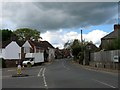
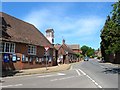
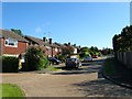
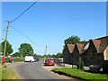
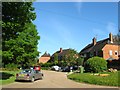
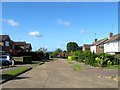
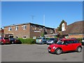
Photos of Ardingly

Area Information
Ardingly is a compact built-up area in England, covering just 1.1 km². Its small size means it is closely knit, with residents likely to know their neighbours. The area’s demographic profile suggests a community skewed towards older residents, with a median age of 70, which may influence the local character and pace of life. Despite its modest size, Ardingly offers a range of amenities within practical reach, including three metro stations—Horsted Keynes, Kingscote, and Sheffield Park—and four rail stations, including Haywards Heath and Wivelsfield. This connectivity supports both daily commutes and access to nearby towns. For families, the presence of St Peter’s CofE Primary School, rated ‘good’ by Ofsted, and the independent Ardingly College provides a mix of educational options. While the broadband score is low at 27, mobile coverage is strong at 81, ensuring most residents can manage daily internet needs. Ardingly’s blend of small-town convenience and proximity to transport links makes it a viable choice for those seeking a quieter, community-focused lifestyle.
- Area Type
- Built Up Area 250
- Area Size
- 1.1 km²
- Population
- Not available
- Population Density
- Not available
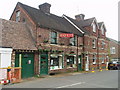
Ardingly’s lifestyle is shaped by its proximity to essential amenities, including five retail outlets such as Morrisons Daily, Co-op High, and Spar, which cater to everyday shopping needs. The area’s three metro stations—Horsted Keynes, Kingscote, and Sheffield Park—offer easy access to nearby towns, while four rail stations provide connections to broader regional networks. Parks and open spaces are not explicitly mentioned in the data, but the presence of metro stations suggests nearby green spaces or recreational areas. The blend of retail, transport, and educational facilities creates a convenient environment for daily life, though the small size of the area means residents may need to travel further for specialist services. The community’s character is likely defined by its compact nature, with a focus on local amenities and ease of access to surrounding regions.
Amenities
Schools
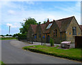
Ardingly offers a range of educational options, including St Peter’s CofE Primary School, a primary school with a ‘good’ Ofsted rating, and Ardingly College, an independent institution. The mix of state and private education provides families with flexibility, though the data does not specify the school catchment areas or student numbers. The presence of both a primary school and an independent college suggests the area may attract households prioritising quality education, though the small size of Ardingly means these institutions serve a broader regional population. Parents should note that St Peter’s CofE Primary’s ‘good’ rating indicates it meets national standards, while Ardingly College’s independent status may offer specialised curricula or smaller class sizes. Families seeking a mix of educational choices may find the area suitable, though further research into school admissions and transport links is advisable.
| Rank | A + A* % | School | Type | Entry gender | Ages |
|---|---|---|---|---|---|
| 1 | N/A | St Peter's CofE Primary School | primary | N/A | N/A |
| 2 | N/A | Ardingly College | independent | N/A | N/A |
Explore more schools in this area
Go to Schools tabDemographics
Ardingly’s population is predominantly older, with a median age of 70, reflecting a community likely shaped by long-term residents rather than recent migration. Home ownership sits at 66%, indicating a mix of owner-occupied properties and rental stock, though the data does not specify the latter’s proportion. The accommodation types and household composition are not detailed, but the high median age suggests a demographic where retirement or semi-retirement is common. The area’s diversity metrics are not quantified, but the ‘total’ category implies a broad range of backgrounds. For those considering living here, the age profile may mean a quieter, less fast-paced environment, with amenities tailored to older residents. The absence of specific data on deprivation or income levels means quality of life assessments must rely on the available figures, such as the strong mobile connectivity and proximity to schools.
Household Size
Accommodation Type
Tenure
Ethnic Group
Religion
Household Composition
Age
Household Deprivation
NS-SEC
Explore more demographic insights in this area
Go to Demographics tabPlanning
Planning Constraints
- Crime RiskLocked