Area Overview for Appledram
Photos of Appledram
Area Information
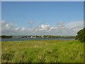
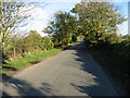
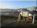
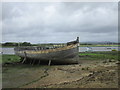
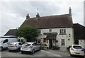
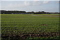
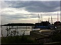
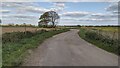
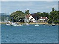
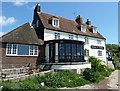
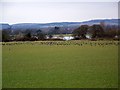
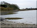
Appledram is a civil parish located on the northeastern upper reach of Chichester Harbour in West Sussex. The area spans 4.4 km² and lies approximately two miles south-west of Chichester's centre. Most of the parish comprises farmland, with no defined village centre remaining. You will find a mixture of agricultural land, fine waterside residences, and business parks situated along Birdham Road. The parish includes Ryman's, a Grade 1 listed building with origins dating back to the 12th century, and the parish church which survives from the original medieval settlement. Access to the harbour is available at Dell Quay, a significant waterside feature that was once the port for Chichester. Residents enjoy magnificent views across the harbour with bobbing boats and abundant wildlife. Looking north, the landscape opens up to farmland towards Chichester Cathedral and the South Downs. The nearest railway station is at Chichester, situated 1.2 miles away. The South Coast railway runs adjacent to the parish, providing a link to wider networks. The area contains protected nature reserves and some protected woodland, meaning development is restricted in certain sections. Living in Appledram means accessing a setting characterised by quintessentially English charm while managing infrastructure constraints typical of a historic and protected rural location.
- Area Type
- Parish
- Area Size
- 4.4 km²
- Population
- Not available
- Population Density
- Not available
Demographics
The community profile of Appledram reflects a settled demographic structure. The median age for residents is 70 years, which is significantly higher than the national average. This indicates that the parish attracts or retains an older population compared to similar areas. The most common age range is recorded as the total age group, suggesting a broad distribution within that upper bracket. There is a strong emphasis on long-term residency, evidenced by the high home ownership level of 75 per cent. Only a quarter of households do not own their property outright. The household composition data is recorded as total, without specific breakdowns into families, single adults, or couples. Similarly, accommodation type, predominant ethnic group, and religious affiliation are recorded as total without further categorisation. This suggests a relatively homogeneous population in terms of tenure, though other cultural metrics are not detailed. The high home ownership rate points to an area where many people have spent decades building estates within the parish boundaries. The low density and farmland dominance reinforce a lifestyle that moves away from fast-paced urban living. You should expect a quiet neighbourhood where residents are likely accustomed to rural surroundings and limited nearby amenities.
Household Size
Accommodation Type
Tenure
Ethnic Group
Religion
Household Composition
Age
Household Deprivation
NS-SEC
Explore more demographic insights in this area
Go to Demographics tabPlanning
Planning Constraints
- Flood RiskPremium
- Ramsar Wetland SitesPremium
- Area of Outstanding Natural BeautyPremium
- Protected Nature ReservePremium
- Protected WoodlandPremium