Area Overview for Appledore
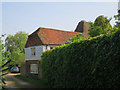
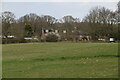
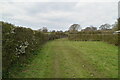
Photos of Appledore

Area Information
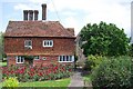
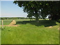
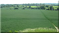
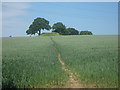
Living in Appledore means settling into a compact civil parish that spans exactly 12.4 square kilometres in the heart of Devon. You are entering a community defined by its specific boundaries and established character rather than rapid expansion. The sheer size of the parish suggests a contained village environment where local routes dominate daily movement. There is no sprawling suburban development here; instead, the layout reflects a traditional settlement pattern. Daily life revolves around the immediate vicinity because the total area is limited. This geographical constraint creates a distinct sense of place that differs from larger municipal districts. Understanding the scale of the parish helps you visualise what you own when you buy property here. The area functions as a self-contained unit with clear limits on its footprint. You are acquiring a stake in a defined locality where the greening around you has fixed proportions.
- Area Type
- Parish
- Area Size
- 12.4 km²
- Population
- Not available
- Population Density
- Not available
Demographics
The community inside Appledore parish displays a clear demographic profile that aligns with retirement and semi-retirement living. The median age for residents sits at 70 years, indicating a population heavily skewed towards older adults. This figure confirms that the majority of households consist of adults rather than young families or single professionals. Home ownership stands at 69%, which signals a stable area where residents have typically purchased their residences over many years. You will find that most accommodation is privately owned rather than tenanted, creating a quiet, settled atmosphere. The data does not break down specific ethnic groups or religious affiliations, but the age distribution provides the clearest picture of the neighbourhood's composition. This profile suggests a slower pace of life where long-term residents have established deep roots. The high ownership rate means turnover can be lower than in commuter towns. When you consider homes in Appledore, you are entering a market dominated by permanent homeowners.
Household Size
Accommodation Type
Tenure
Ethnic Group
Religion
Household Composition
Age
Household Deprivation
NS-SEC
Explore more demographic insights in this area
Go to Demographics tabPlanning
Planning Constraints
- Flood RiskPremium
- Ramsar Wetland SitesPremium
- Area of Outstanding Natural BeautyPremium
- Protected Nature ReservePremium
- Protected WoodlandPremium
- Crime RiskPremium