Area Overview for WN7 4BA
Photos of WN7 4BA
51 photos from this area
Area Information
Key information about the WN7 4BA including its size, population, and administrative classification.
- Area Type
- Postcode
- Area Size
- 5.4 hectares
- Population
- 2086
- Population Density
- 5315 people/km²
House Prices in WN7 4BA
8
Properties
-
Average Sold Price
-
Lowest Price
-
Highest Price
Showing 8 properties
| Address | Type | Beds | Baths | Last Sale Price | Last Sale Date | |
|---|---|---|---|---|---|---|
| Frankie & Benny's, Unit 4, The Loom, Derby Street, Leigh, WN7 4BA | Retail | - | - | - | - | |
| Ayubowan Sri Lankan Restaurant & Buffet, Unit 2, The Loom, Derby Street, Leigh, WN7 4BA | Restaurant | - | - | - | - | |
| Nando's, Unit 3, The Loom, Derby Street, Leigh, WN7 4BA | Retail | - | - | - | - | |
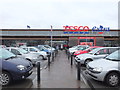
| Sports Direct Tesco Extra, The Loom, Derby Street, Leigh, WN7 4BA | shop | - | - | - | - | |
| Tesco Mobile, The Loom, Derby Street, Leigh, WN7 4BA | shop | - | - | - | - | |
| Tesco Cafe, The Loom, Derby Street, Leigh, WN7 4BA | Restaurant | - | - | - | - | |
| Tesco Instore Pharmacy, Derby Street, Leigh, WN7 4BA | shop | - | - | - | - | |
| Inpost Parcel Locker Tesco Extra, The Loom, Derby Street, Leigh, WN7 4BA | shop | - | - | - | - |
Energy Efficiency in WN7 4BA
Amenities
Schools
| Rank | School | Type | Entry gender | Ages |
|---|
Explore more schools in this area
Go to Schools tabDemographics
Household Size
One person
most common
Accommodation Type
Houses
most common
Tenure
44
majority
Ethnic Group
White
most common
Religion
N/A
most common
Household Composition
N/A
most common
Age
47
median
Adults (30-64 years)
most common
Household Deprivation
N/A
with no deprivation
NS-SEC
19
in Lower managerial occupations
Explore more demographic insights in this area
Go to Demographics tabPlanning
Planning Constraints
- Flood RiskPremium
- Ramsar Wetland SitesPremium
- Area of Outstanding Natural BeautyPremium
- Protected Nature ReservePremium
- Protected WoodlandPremium