Area Overview for Wilmslow Lacey Green Ward
Photos of Wilmslow Lacey Green Ward


Area Information
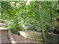
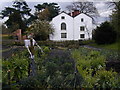
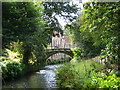
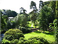
Living in Wilmslow Lacey Green Ward means residing within a compact and defined community across North West England. This electoral ward sits within the Cheshire East unitary authority at British National Grid Reference SJ 841.99 827.98. The total area covers 7.1 square kilometres, creating a dense local environment for its residents. Currently, the population stands at 1,584 individuals, which translates to an average density of 223 people per square kilometre. This specific size and population figure distinguish the ward from larger areas that might sprawl more broadly or contain higher head counts. The location identifies it as one of 52 wards within the wider Cheshire East administrative structure. Prospective buyers looking at Wilmslow Lacey Green Ward will find a locality that balances residential space with concentrated community life. The ward profile provides clear geographical boundaries and demographic markers that define the daily rhythm of the neighbourhood. You are considering homes in Wilmslow Lacey Green Ward within this well-mapped section of Cheshire. The area's specific coordinates place it firmly in the recognized framework of local government planning and census reporting. Daily life here revolves around this specific 7.1-kilometre square of land where over 1,500 people call their homes.
- Area Type
- District Borough Unitary Ward
- Area Size
- 7.1 km²
- Population
- 1584
- Population Density
- 223 people/km²
Demographics
The community within Wilmslow Lacey Green Ward reflects a notably mature age profile compared to the national average. The median age for residents is exactly 70 years old. This statistic indicates that the population skews significantly towards older age groups. Although a section on most common age ranges appears in the demographic breakdown, the headline median figure provides the clearest picture of the local retiree population. With more than two-thirds of residents owning their homes directly, the ownership rate reaches 68 percent. This high level of home ownership suggests a stable, settled community rather than a transient rental market. The total household composition data supports the view that families or couples in this age demographic form the primary living units. Accommodation types in the ward cater primarily to this older demographic需要 specific data to describe fully, though the high ownership rate strongly implies detached or semi-detached family housing converted for retirement. While specific ethnicity and religious data are not explicitly detailed in the provided snapshot, the uniformity of age and ownership paints a coherent social picture. For those assessing quality of life, the age profile means services and amenities likely cater to older needs. Living in Wilmslow Lacey Green Ward involves surrounding yourself with neighbours who share a similar life stage. The lack of young families in the central statistic reflects the ward's role as a retirement-centric locality.
Household Size
Accommodation Type
Tenure
Ethnic Group
Religion
Household Composition
Age
Household Deprivation
NS-SEC
Explore more demographic insights in this area
Go to Demographics tabPlanning
Planning Constraints
- Flood RiskPremium
- Ramsar Wetland SitesPremium
- Area of Outstanding Natural BeautyPremium
- Protected Nature ReservePremium
- Protected WoodlandPremium
- Crime RiskPremium