Area Overview for Whitley
Photos of Whitley


Area Information
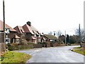
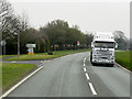
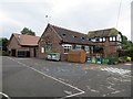
Living in Whitley offers a quiet settlement experience rooted in its status as a civil parish covering approximately 8.8 square kilometres of land. You will find an environment where space is abundant compared to the denser towns often sought by first-time buyers in the region. The character of this area is defined by low population density, creating a neighbourhood feel that prioritises immediacy and locality over the hustle of larger urban centres. There are no commercial hubs or high-rise developments here; instead, the landscape is dominated by residential properties and open spaces typical of the English countryside. Daily life in Whitley revolves around a close-knit community structure where neighbours know one another. The area lacks the complexity of larger council estates, meaning your exposure to external influences is minimal. This simplicity appeals to those who value stability and a predictable routine. However, you should be aware that this exclusivity means fewer large-scale amenities are located within the parish boundaries. Residents often rely on proximity to nearby larger towns for shopping and entertainment. Your morning commute or evening walk will reflect this rural setting, with access to green spaces being a primary feature of your surroundings. ### The community in Whitley presents a distinctly older demographic profile that shapes the local atmosphere. The median age for residents standing at seventy years indicates a retirement-oriented population rather than a youthful family cluster. Most households contain people of the total age range, suggesting that families with young children are not the norm. This age distribution influences local businesses, which likely cater to the needs of pensioners rather than teenagers or young professionals. Home ownership stands at an impressive eighty-seven per cent across the parish. Such a high rate signals a stable, settled population where residents have built long-term ties to the land. The prevalence of owned homes contributes to a slower pace of life and less transient activity compared to rental-heavy districts. Accommodation types are not individually numbered in the available records, but the overwhelming figure of home ownership suggests a significant portion of the housing stock consists of detached or semi-detached properties suitable for single occupants or couples. Diversity data regarding ethnic groups and religion are not provided in the record, so the community appears to maintain traditional demographic patterns common in many smaller English parishes. This stability means you will encounter a predictable social fabric where established neighbours form the core of the local dynamic. ### The property market in Whitley is dominated by existing homeowners, with eighty-seven per cent of properties in private hands. This statistic paints a clear picture of a settled area where the housing stock reflects generations of accumulation rather than rapid change. You are looking primarily at owner-occupied homes, which often indicates well-maintained properties suitable for retirement or downsizing. The nature of the market implies that new builds are scarce, and any vacant properties likely exist within the total residential count rather than on the active auction block. Homes in Whitley cater to a specific buyer demographic seeking tranquillity and established gardens rather than modern urban conveniences. High home ownership rates often correlate with larger plots and traditional architectural styles found in older parishes. If you are considering purchasing, you will face a market characterised by limited turnover compared to buy-to-let hotspots. The lack of rental data in the provided information further suggests that speculative investment activity is minimal here. You are entering a niche market where the primary consideration is lifestyle rather than capital appreciation or rental yield. This environment suits those who have their means secured and wish to reside in a civil parish with a strong sense of individual ownership and territorial pride. ### Digital connectivity in Whitley presents a mixed picture depending on how you require the network. Mobile coverage scores well with a rating of eighty-two out of one hundred, indicating good signal strength for voice calls and standard data usage. However, fixed broadband quality scores only fifty-two out of one hundred, which classifies as a fair to poor standard for the modern era. This discrepancy means you can rely on mobile data for most daily communication, but high-speed internet access for heavy workloads may be inconsistent. For professionals working from home, this broadband limitation could be a significant constraint. Streaming large files or attending video conferences might suffer from the lower fixed-line speeds you would expect in more developed zones. Daily internet use for browsing and email remains functional, but if your livelihood depends on robust, uninterrupted online access, you should test the connection before committing to a home here. Residents who are not reliant on heavy data traffic will find the mobile network sufficiently robust. The area does not host major transport hubs within its 8.8 square kilometre boundary, so your digital connection may be your most vital link to the outside world. Powering your home and working online requires accepting that the fixed broadband experience may not meet the standards of faster, urbanised districts. ### Safety and environmental considerations in Whitley are overwhelmingly positive for anyone settling here. Crime risk assessment shows a score of ninety out of one hundred, indicating low crime risk and below-average rates for the region. You can expect a secure neighbourhood where personal safety is rarely a concern. Flood risk coverage is minimal with a score of 2.27 out of one hundred, confirming that you face low risk of water damage. This makes Whitley a highly resilient choice when establishing your permanent residence. Planning constraints further reinforce the desirability of the location. There is no Ramsar wetland sites coverage, no Area of Outstanding Natural Beauty designation that might restrict development, and no protected nature reserves or woodlands imposing strict building limitations. These clearances mean that local planning processes are likely straightforward and unaffected by stringent environmental protections that complicate construction in other rural regions. The absence of these constraints does not diminish the natural beauty of the parish, but it ensures that the 8.8 square kilometres remain largely unencumbered by regulatory red tape. For a homebuyer prioritising both personal security and environmental stability, Whitley delivers a clean slate across all key safety metrics. ### Who comprises the main demographic living in Whitley?The community in Whitley is characterised by an older population with a median age of seventy. Most households include people of the total age range, reflecting a senior demographic rather than young families. This is one of the defining traits of civil parish life. Is Whitley a good place for working from home given the internet?Mobile coverage is good with a score of 82 out of 100, suitable for standard communication. However, fixed broadband quality scores only 52 out of 100, which is a fair standard. Heavy data usage or video conferencing may experience interruptions compared to major urban areas. How safe is the neighbourhood in Whitley regarding crime and environment?Whitley scores 90 out of 100 for crime risk, indicating low crime rates and a safer neighbourhood. Environmental assessments also pass with flying colours, showing low flood risk at 2.27 and zero coverage for protected nature reserves or woodlands, ensuring minimal planning constraints. What is the nature of the housing market in this parish?Home ownership is remarkably high at 87% in Whitley, meaning the market is almost exclusively owner-occupied. This creates a stable, settled environment where the majority of residents have long-term ties to the area, unlike rental-heavy developments found elsewhere.
- Area Type
- Parish
- Area Size
- 8.8 km²
- Population
- Not available
- Population Density
- Not available
Demographics
The community in Whitley presents a distinctly older demographic profile that shapes the local atmosphere. The median age for residents standing at seventy years indicates a retirement-oriented population rather than a youthful family cluster. Most households contain people of the total age range, suggesting that families with young children are not the norm. This age distribution influences local businesses, which likely cater to the needs of pensioners rather than teenagers or young professionals. Home ownership stands at an impressive eighty-seven per cent across the parish. Such a high rate signals a stable, settled population where residents have built long-term ties to the land. The prevalence of owned homes contributes to a slower pace of life and less transient activity compared to rental-heavy districts. Accommodation types are not individually numbered in the available records, but the overwhelming figure of home ownership suggests a significant portion of the housing stock consists of detached or semi-detached properties suitable for single occupants or couples. Diversity data regarding ethnic groups and religion are not provided in the record, so the community appears to maintain traditional demographic patterns common in many smaller English parishes. This stability means you will encounter a predictable social fabric where established neighbours form the core of the local dynamic. ### The property market in Whitley is dominated by existing homeowners, with eighty-seven per cent of properties in private hands. This statistic paints a clear picture of a settled area where the housing stock reflects generations of accumulation rather than rapid change. You are looking primarily at owner-occupied homes, which often indicates well-maintained properties suitable for retirement or downsizing. The nature of the market implies that new builds are scarce, and any vacant properties likely exist within the total residential count rather than on the active auction block. Homes in Whitley cater to a specific buyer demographic seeking tranquillity and established gardens rather than modern urban conveniences. High home ownership rates often correlate with larger plots and traditional architectural styles found in older parishes. If you are considering purchasing, you will face a market characterised by limited turnover compared to buy-to-let hotspots. The lack of rental data in the provided information further suggests that speculative investment activity is minimal here. You are entering a niche market where the primary consideration is lifestyle rather than capital appreciation or rental yield. This environment suits those who have their means secured and wish to reside in a civil parish with a strong sense of individual ownership and territorial pride. ### Digital connectivity in Whitley presents a mixed picture depending on how you require the network. Mobile coverage scores well with a rating of eighty-two out of one hundred, indicating good signal strength for voice calls and standard data usage. However, fixed broadband quality scores only fifty-two out of one hundred, which classifies as a fair to poor standard for the modern era. This discrepancy means you can rely on mobile data for most daily communication, but high-speed internet access for heavy workloads may be inconsistent. For professionals working from home, this broadband limitation could be a significant constraint. Streaming large files or attending video conferences might suffer from the lower fixed-line speeds you would expect in more developed zones. Daily internet use for browsing and email remains functional, but if your livelihood depends on robust, uninterrupted online access, you should test the connection before committing to a home here. Residents who are not reliant on heavy data traffic will find the mobile network sufficiently robust. The area does not host major transport hubs within its 8.8 square kilometre boundary, so your digital connection may be your most vital link to the outside world. Powering your home and working online requires accepting that the fixed broadband experience may not meet the standards of faster, urbanised districts. ### Safety and environmental considerations in Whitley are overwhelmingly positive for anyone settling here. Crime risk assessment shows a score of ninety out of one hundred, indicating low crime risk and below-average rates for the region. You can expect a secure neighbourhood where personal safety is rarely a concern. Flood risk coverage is minimal with a score of 2.27 out of one hundred, confirming that you face low risk of water damage. This makes Whitley a highly resilient choice when establishing your permanent residence. Planning constraints further reinforce the desirability of the location. There is no Ramsar wetland sites coverage, no Area of Outstanding Natural Beauty designation that might restrict development, and no protected nature reserves or woodlands imposing strict building limitations. These clearances mean that local planning processes are likely straightforward and unaffected by stringent environmental protections that complicate construction in other rural regions. The absence of these constraints does not diminish the natural beauty of the parish, but it ensures that the 8.8 square kilometres remain largely unencumbered by regulatory red tape. For a homebuyer prioritising both personal security and environmental stability, Whitley delivers a clean slate across all key safety metrics. ### Who comprises the main demographic living in Whitley?The community in Whitley is characterised by an older population with a median age of seventy. Most households include people of the total age range, reflecting a senior demographic rather than young families. This is one of the defining traits of civil parish life. Is Whitley a good place for working from home given the internet?Mobile coverage is good with a score of 82 out of 100, suitable for standard communication. However, fixed broadband quality scores only 52 out of 100, which is a fair standard. Heavy data usage or video conferencing may experience interruptions compared to major urban areas. How safe is the neighbourhood in Whitley regarding crime and environment?Whitley scores 90 out of 100 for crime risk, indicating low crime rates and a safer neighbourhood. Environmental assessments also pass with flying colours, showing low flood risk at 2.27 and zero coverage for protected nature reserves or woodlands, ensuring minimal planning constraints. What is the nature of the housing market in this parish?Home ownership is remarkably high at 87% in Whitley, meaning the market is almost exclusively owner-occupied. This creates a stable, settled environment where the majority of residents have long-term ties to the area, unlike rental-heavy developments found elsewhere.
Household Size
Accommodation Type
Tenure
Ethnic Group
Religion
Household Composition
Age
Household Deprivation
NS-SEC
Explore more demographic insights in this area
Go to Demographics tabPlanning
Planning Constraints
- Flood RiskPremium
- Ramsar Wetland SitesPremium
- Area of Outstanding Natural BeautyPremium
- Protected Nature ReservePremium
- Protected WoodlandPremium
- Crime RiskPremium