Area Overview for Wasdale
Photos of Wasdale


Area Information
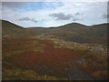
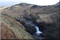
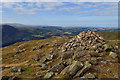
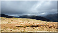
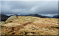
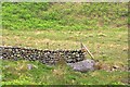
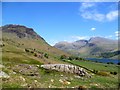
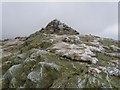
Living in Wasdale means residing in a remote civil parish that covers 70.1 km² of rugged Lake District terrain. This area is distinct because its isolation shapes a very specific daily rhythm for residents. You are not buying into a typical town centre lifestyle but rather a setting defined by dramatic mountains and deep valleys. The median age of 70 years reveals that the community is dominated by long-term retirees or permanent residents who chose this location decades ago. A significant 82% of households own their homes, indicating deep-rooted families rather than transient tenants. While the landscape offers breathtaking scenery, the practicalities of life here are demanding. Commutes to nearby services are inevitable, and the population density is low. Those seeking a quiet life with a permanent connection to nature will find what they need in Wasdale. However, you should be prepared for a slower pace and limited facilities compared to larger湖区 settlements. The sheer size of the parish means that everything from shops to healthcare requires travel. This area is suitable for those who value privacy and natural beauty above convenience.
- Area Type
- Parish
- Area Size
- 70.1 km²
- Population
- Not available
- Population Density
- Not available
Demographics
The community in Wasdale is exceptionally skewed towards older residents, confirmed by a median age of 70 years. This demographic profile suggests a location favoured by retirees or those with established permanent ties rather than young families or transient workers. Home ownership stands at an impressive 82%, which indicates a settlement where people build their lives locally rather than renting temporarily. This high rate of ownership reflects a stable, settled population. The demographic data does not specify household composition or predominant ethnic groups, but the age statistics alone paint a picture of an elderly community. With such a high proportion of older adults, the local amenities and services are likely tailored to their needs. The low diversity in age means you will not find a mix of students or young professionals. Instead, you will live among people who have chosen this parish as a long-term home. This stability offers a predictable community environment, but it also means the culture may not change quickly or adapt to modern urban trends.
Household Size
Accommodation Type
Tenure
Ethnic Group
Religion
Household Composition
Age
Household Deprivation
NS-SEC
Explore more demographic insights in this area
Go to Demographics tabPlanning
Planning Constraints
- Flood RiskPremium
- Ramsar Wetland SitesPremium
- Area of Outstanding Natural BeautyPremium
- Protected Nature ReservePremium
- Protected WoodlandPremium
- Crime RiskPremium