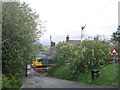
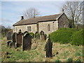
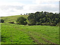
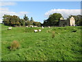
Area Overview for Upper Denton
Photos of Upper Denton
Area Information
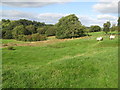
Upper Denton is a civil parish covering 4.2 km² in England. This relatively small footprint defines the physical boundaries of the locality, creating a contained environment where residents live close to their neighbours. Living in Upper Denton means accepting the scale of this specific rural settlement. You will experience a community shaped by its limited geography rather than sprawling urban development. The area stands as a distinct entity defined by its parish status and measured boundaries. Your daily life here unfolds within these precise kilometre limits. You are not looking at a broad metropolitan zone here; instead, you are engaging with a specific, bounded neighbourhood. The distinctiveness of Upper Denton arises from this concentrated layout. Neither the large scale nor the vague municipal boundaries apply to this location. You deal with a clear, defined patch of land that serves as your home base. This specificity shapes everything from local services to the pace of life. Upper Denton operates within tight borders while functionally connecting to the wider region. You move through an area where every square kilometre counts towards the total. The parish structure governs the administration of your doorstep. Upper Denton remains a self-contained community with a clear identity. You live in a place where the map lines up exactly with your sense of home.
- Area Type
- Parish
- Area Size
- 4.2 km²
- Population
- Not available
- Population Density
- Not available
Demographics
The community profile in Upper Denton reveals a distinctly older population. The median age stands at 70, indicating that a significant proportion of residents are senior citizens. Most household composition data aggregates as total, reflecting the consolidated nature of demographic records for this parish. Eighty per cent of residents own their homes, a figure that underscores the stability of the local population. This high ownership rate suggests a settled community rather than a transient group. You will find that lifestyle patterns here align with those of a mature demographic. The data does not separate specific age brackets beyond the median, but the average clearly points to retirees or older adults. Household types remain grouped under total statistics, offering a broad view of family structures. Predominant ethnic group and religion data are recorded as total, meaning these categories do not show granular breakdowns in the available figures. Deprivation data is not provided for this area. You must understand that quality of life here is largely defined by this older, owner-occupied demographic. The 80% ownership figure is a concrete reality that shapes the daily rhythm of the village. It also influences how services are delivered and how neighbours interact. Living in Upper Denton, you join a cohort where life typically slows after full-time work ends. The community is defined by this concentration of older homeowners.
Household Size
Accommodation Type
Tenure
Ethnic Group
Religion
Household Composition
Age
Household Deprivation
NS-SEC
Explore more demographic insights in this area
Go to Demographics tabPlanning
Planning Constraints
- Flood RiskPremium
- Ramsar Wetland SitesPremium
- Area of Outstanding Natural BeautyPremium
- Protected Nature ReservePremium
- Protected WoodlandPremium
- Crime RiskPremium