Area Overview for Tiverton and Tilstone Fearnall
Photos of Tiverton and Tilstone Fearnall


Area Information
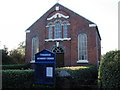
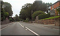
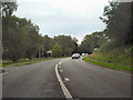
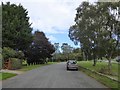
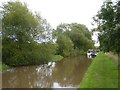
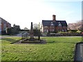
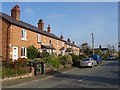
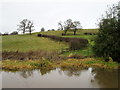
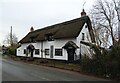
Tiverton and Tilstone Fearnall is a rural civil parish located in the Cheshire West and Chester district of North West England. This area encompasses 1691 acres of land and 14 acres of water, including sections of the Shropshire Union Canal and the River Gowy. The parish straddles the Whitchurch and Nantwich roads and includes distinct hamlets such as Tiverton Heath, Four Lane Ends, Beeston Brook, and Tilstone. You will find approximately 2,168 residents living across 208 dwellings within this landscape. The community relies on nearby Tarporley, situated two miles north, for broader connectivity and market services. Your daily life here centres on a traditional village atmosphere characterised by rural views and solitude. You have access to 40 footpaths covering 28km, including the Sandstone Trail, which winds through the parish. The local heart currently features the Methodist Chapel, the Village Hall, and a single public house offering a restaurant and campsite. While traditional village institutions like the post office and primary school have closed, small businesses and an Indian restaurant on the parish boundaries continue to support local commerce. This setting blends older agricultural history with limited modern extensions, creating a residential environment defined by green spaces and historical heritage.
- Area Type
- Parish
- Area Size
- 9.3 km²
- Population
- Not available
- Population Density
- Not available
Demographics
The community profile of Tiverton and Tilstone Fearnall reflects an established demographic profile typical of rural England. The median age for residents is 70 years, and the age data under a 'Total'** is recorded as the most common category. This indicates an area with an older population base compared to national averages. Over 76% of homes are owner-occupied, suggesting that the area attracts long-term residents rather than short-term rentals or commuters seeking temporary accommodation. You will find few private landlords or student properties within this parish. The available information regarding household composition confirms that total household numbers are recorded, while specific breakdowns into family types or single-person households are not included in the provided statistics. Similarly, the data does not specify the predominant ethnic group, religious affiliation, or detailed breakdown of accommodation types beyond the high ownership figure. Despite the absence of granular ethnicity or religion statistics, the high ownership rate supports the view of a stable, settled community where residents have resided for generations. The lack of rental data further reinforces the picture of a home where ownership is the primary norm, rather than a transit point for residents or investors.
Household Size
Accommodation Type
Tenure
Ethnic Group
Religion
Household Composition
Age
Household Deprivation
NS-SEC
Explore more demographic insights in this area
Go to Demographics tabPlanning
Planning Constraints
- Flood RiskPremium
- Ramsar Wetland SitesPremium
- Area of Outstanding Natural BeautyPremium
- Protected Nature ReservePremium
- Protected WoodlandPremium
- Crime RiskPremium