Area Overview for Talbot Ward
Photos of Talbot Ward


Area Information
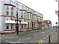
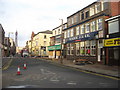
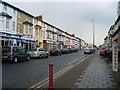
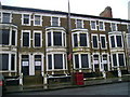
Talbot Ward sits centrally within the Blackpool Borough, covering a defined area of 1.9 square kilometres in the North West of England. This unitary authority ward forms part of the Blackpool South constituency and is anchored around Talbot Road. The population stands at 6,527 residents according to the 2021 census. Living in Talbot Ward means navigating a specific urban environment that serves as a core district within the larger town. The ward's location provides a central position within Blackpool, which influences local commuting patterns and access to city-wide amenities. You will find that daily life here revolves around the main road network and the immediate neighbourhood structures surrounding this coordinate point. The area operates under its own administrative framework as a ward of the borough council. Its central placement makes it a focal point for local governance and community identity within the broader Blackpool South administrative zone.
- Area Type
- District Borough Unitary Ward
- Area Size
- 1.9 km²
- Population
- Not available
- Population Density
- Not available
Demographics
The community in Talbot Ward reflects a mature population profile with a median age of 70 years. This demographic skew indicates that the area houses a significant number of older residents compared to the national average. The most common age range reflects this elderly-dominated cohort. Home ownership stands at 39 per cent of the total households, suggesting a higher reliance on rented accommodation or shared living arrangements among the demographic present. The household composition data shows the total breakdown of family units across the ward. Accommodation types vary to suit these specific household needs, though specific breakdowns are not detailed beyond the total category. Predominant ethnic groups and religious affiliations exist within this population but remain unbroken out in the current statistics. The high median age defines the social rhythm of Talbot Ward, influencing local service usage and community interaction. You should expect a neighbourhood where long-term residents and older adults form the backbone of local life.
Household Size
Accommodation Type
Tenure
Ethnic Group
Religion
Household Composition
Age
Household Deprivation
NS-SEC
Explore more demographic insights in this area
Go to Demographics tabPlanning
Planning Constraints
- Flood RiskPremium
- Ramsar Wetland SitesPremium
- Area of Outstanding Natural BeautyPremium
- Protected Nature ReservePremium
- Protected WoodlandPremium