Area Overview for Stoak
Photos of Stoak


Area Information
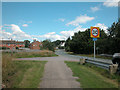
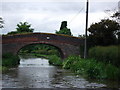
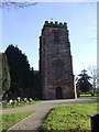
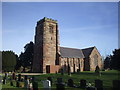
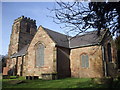
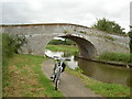
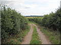
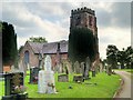
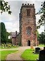
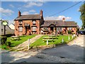
Stoak is a small civil parish located in Cheshire West and Chester, covering an area of 2.6 square kilometres. You will find this quiet village situated near the intersection where the M53 and M56 motorways meet. The location places you close to the Shropshire Union Canal to the east. The parish changed its name from Stoke in 2015 to avoid confusion with other nearby places in the county. Contemporary residents access the village via key national roads which facilitate easy travel to the wider North West region. St Lawrence's Church serves as a central landmark within the settlement. Denison's Bridge also marks a significant historic feature associated with the local history. Living here means enjoying a defined community boundary while maintaining proximity to major transport links. The compact size of the parish ensures that daily life remains grounded in a specific local identity. You navigate this environment with direct access to arterial routes without being overwhelmed by large-scale urban sprawl. The parish boundaries are clear, contained by significant infrastructure on the western edge and waterways on the eastern side. This positioning defines the character of daily life for everyone residing in this distinct Cheshire community.
- Area Type
- Parish
- Area Size
- 2.6 km²
- Population
- Not available
- Population Density
- Not available
Demographics
The community within Stoak reflects a mature population structure with a median age of 70 years. You will find that residents fall into the total age category, indicating a population skewed significantly toward older demographics. House ownership stands at 80 per cent across the parish. This high rate indicates that the majority of residents have built their own homes over time rather than renting. The household composition data shows totals that align with this settled nature, suggesting stable family units often shared with extended relatives. You will encounter very limited diversity in the predominant ethnic group data which remains at a zero value for specific subgroup breakdowns in the available records. Similarly, religious affiliation data presents a total figure without specific denominational splits recorded in the current dataset. These statistics reflect a settled village community rather than a transient urban population. The demographics suggest a place where long-term residents form the core of social interaction. You encounter a homogenous community where generational ties are likely strong. The social fabric appears tightly woven around these older, owner-occupied households.
Household Size
Accommodation Type
Tenure
Ethnic Group
Religion
Household Composition
Age
Household Deprivation
NS-SEC
Explore more demographic insights in this area
Go to Demographics tabPlanning
Planning Constraints
- Flood RiskPremium
- Ramsar Wetland SitesPremium
- Area of Outstanding Natural BeautyPremium
- Protected Nature ReservePremium
- Protected WoodlandPremium
- Crime RiskPremium