Area Overview for St. John's Castlerigg and Wythburn
Photos of St. John's Castlerigg and Wythburn
Area Information
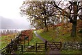
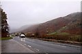
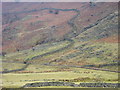
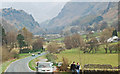
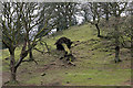
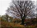
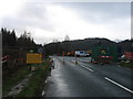
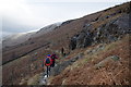
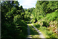
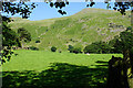
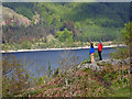
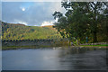
Living in St. John's Castlerigg and Wythburn means embracing a distinctly rural lifestyle within the Cumberland district of Cumbria. This civil parish spans 72.2 km², placing it firmly in the North West of England. The area covers familiar ground for visitors to the Lake District, running along the A591 road from Dunmail Raise south to the outskirts of Keswick north. You will find the parish centre defined by the historic village of St John's in the Vale, the ancient site at Castlerigg, the hamlets of Legburthwaite and Naddle valley, and the expansive landscape surrounding Thirlmere reservoir. Historically, the parish boundaries shifted significantly; territory was lost to the town of Keswick in the late 19th and early 20th centuries, reducing the land area by several hundred acres over time. Daily life is shaped by the valley setting, offering views of Blencathra and proximity to the reservoir. The character of the area is one of tranquility, heavily influenced by hill farming, forestry, and the quiet presence of scheduled monuments like Castlerigg Stone Circle. Residents enjoy a peaceful setting away from the main hubs, yet remain connected to the economic and social life of Keswick and beyond. The community retains a deep connection to its history, evident in structures like the Grade II listed churches that have survived centuries of change.
- Area Type
- Parish
- Area Size
- 72.2 km²
- Population
- Not available
- Population Density
- Not available
Demographics
The community in St John's Castlerigg and Wythburn presents a profile distinct from bustling urban centres. With a median age of 70, the population is predominantly older, reflecting the needs and lifestyle choices of retirees or long-term rural residents. Home ownership is the prevailing mode of dwelling, standing at 83% within the parish. This high figure suggests a stable community where residents have established deep roots in the countryside for extended periods. The data does not provide a breakdown of household composition by size, nor does it detail specific ethnic or religious demographics, but the high ownership rate indicates a settled population. The absence of private rental tenure as a dominant force points to an area where property is largely held by those who permanently reside there. This demographic reality means that if you are looking for homes in St John's Castlerigg and Wythburn, you will primarily encounter owner-occupiers rather than landlords. The environment supports a slower pace of life, reinforced by the fact that the residents are likely to be past their most mobile years. The community is therefore likely to value tradition and local continuity. While the specific age distribution within the 70 median is not detailed, the figure itself paints a picture of a mature neighbourhood where stability outweighs rapid turnover.
Household Size
Accommodation Type
Tenure
Ethnic Group
Religion
Household Composition
Age
Household Deprivation
NS-SEC
Explore more demographic insights in this area
Go to Demographics tabPlanning
Planning Constraints
- Flood RiskPremium
- Ramsar Wetland SitesPremium
- Area of Outstanding Natural BeautyPremium
- Protected Nature ReservePremium
- Protected WoodlandPremium
- Crime RiskPremium