Area Overview for Smithills Ward
Photos of Smithills Ward


Area Information
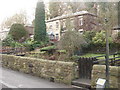
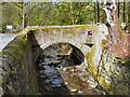
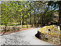
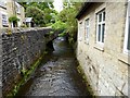
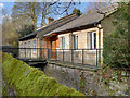
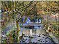
Smithills Ward sits within the Metropolitan Borough of Bolton in Greater Manchester, covering an area of 12 square kilometres. The ward contains a population of 1,746 people, resulting in a relatively low density of 145 people per square kilometre. This small footprint creates a contained community centred around its most significant landmark, Smithills Hall. This Grade I listed building has stood since the 15th century and is now owned by Bolton Council. The site historically occupied a defensive location on gently sloping moorland known locally as 'smooth hills'. First recorded in 1322, the manor passed through several prominent families before becoming a museum and residential home. Life in Smithills Ward is defined by its proximity to this historic estate and its position within the Bolton landscape. The area includes the hamlet of Smithills, which offers easy access to nearby locations like Astley and Raveden Brooks where the hall's moat was once featured. Prospective buyers should note the specific postcode associated with the heart of this ward, BL1 4FB, marks the coordinates near the historic estate. The low population density suggests a quieter environment compared to more urban parts of Greater Manchester. You can expect to find housing stock that reflects the area's history, a mix of properties surrounding a site with over 700 years of recorded ownership. The ward offers a distinct character within the borough, anchored by a property of national historical importance.
- Area Type
- District Borough Unitary Ward
- Area Size
- 12.0 km²
- Population
- 1746
- Population Density
- 145 people/km²
Demographics
The community in Smithills Ward presents a distinct demographic profile characterised by an older population. The median age of residents stands at 70 years, indicating that the majority of households are likely managed by those of retirement age or senior living. While the most common age range data labels simply as 'Age: Total', the high median strongly suggests a retirement haven. This profile influences the types of activities and services you might encounter daily within the ward. Home ownership is a dominant feature of local life, with 68% of residents owning their property outright or with a mortgage. This high rate contrasts sharply with typical student or young professional hubs in Greater Manchester. Household composition and accommodation types reflect this mature demographic, though specific breakdowns for these categories are not detailed in the current data. You will find a stable community where long-term residents have likely lived for decades. The area does not exhibit the rapid turnover often seen in new developments. The predominance of owner-occupied homes creates a sense of established neighbourhood character rather than a transient rental market. Residents here are more likely to have deep local roots, which can foster a tight-knit social circle. When evaluating this area, consider that the population is not primarily driven by young families or latesingle professionals. The demographic reality means the local economy and social hubs cater to the needs of an older cohort. This stability can offer peace but may limit specific amenities found in more mixed-age areas.
Household Size
Accommodation Type
Tenure
Ethnic Group
Religion
Household Composition
Age
Household Deprivation
NS-SEC
Explore more demographic insights in this area
Go to Demographics tabPlanning
Planning Constraints
- Flood RiskPremium
- Ramsar Wetland SitesPremium
- Area of Outstanding Natural BeautyPremium
- Protected Nature ReservePremium
- Protected WoodlandPremium
- Crime RiskPremium