Area Overview for SK6 1NQ
Photos of SK6 1NQ


Area Information
Living in SK6 1NQ places you within a compact residential cluster covering just 2380 square metres. This small postcode area houses a population of 1375 people, creating a tight-knit environment where neighbours are likely to know one another. The location sits with an exceptionally high population density, meaning homes are situated close together. Daily life here revolves around local convenience rather than expansive open spaces. You are surrounded by established communities where the pace of living is determined by foot traffic and local interactions. The area functions as a distinct residential pocket within the wider Greater Manchester region. Prospective buyers should note that this is a specific postcode rather than a traditional village or suburb designation. Your immediate surroundings are defined by high occupancy rates and a concentration of individual households. The environment is characterised by its density and the proximity of residents to shared local infrastructure. You are not in a sprawling development; you are in a concentrated zone where every resident shares the same limited footprint. This definition shapes the noise levels, traffic flow, and community atmosphere you can expect on a typical day.
- Area Type
- Postcode
- Area Size
- 2380 m²
- Population
- 1375
- Population Density
- 1706 people/km²
The property market in SK6 1NQ is defined by its status as an owner-occupied pocket. With an 80% home ownership rate, the area functions primarily as an established market for existing homeowners rather than a hub for new-build buyers or tenant searching. Houses constitute the main form of accommodation, meaning you will encounter traditional English residential architecture. This high ownership percentage reduces the volume of rental listings available compared to areas with significant student or corporate populations. Buyers looking for homes in SK6 1NQ are entering a competitive environment where sellers have a personal stake in the property. The small total area size of 2380 square metres limits the selection of distinct estates or large developments. Instead, properties likely exist as individual private dwellings within the compact cluster. Financial trends here depend heavily on the owner-occupiers' willingness to sell rather than landlord-driven price manipulation. When you view properties near SK6 1NQ, you are looking at a stable market where residents value the area enough to remain long-term.
House Prices in SK6 1NQ
Showing 2 properties
| Address | Type | Beds | Baths | Last Sale Price | Last Sale Date | |
|---|---|---|---|---|---|---|
| 8 Quarry Street, Woodley, Stockport, SK6 1NQ | Semi-detached | 2 | 2 | £251,500 | May 2023 | |
| 10 Quarry Street, Woodley, Stockport, SK6 1NQ | Semi-detached | - | - | - | - |
Energy Efficiency in SK6 1NQ
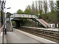
Your daily lifestyle in SK6 1NQ centres on a curated selection of retail and transport amenities within easy reach. Five retail locations serve your shopping needs, including Iceland Romiley for grocery shopping, Asda Bredbury for larger centre requirements, and Co-op Berrycroft for local corner shop convenience. Five railway stations operate nearby, giving you flexible travel options to Woodley, Bredbury, and Romiley depending on your destination. Metro services connect you to Audenshaw, Ashton Moss, and Droylsden, expanding your horizons beyond the immediate postcode. This arrangement ensures that essential errands require minimal travel time while longer journeys remain straightforward via public transit. You do not need a car for most weekly tasks, though one provides added flexibility if desired. The presence of major supermarkets like Iceland and Asda means you have access to full ranges of goods without leaving the local zone. Living in SK6 1NQ offers a balance between residential privacy and commercial accessibility without the noise of a dense urban street.
Amenities
Schools
| Rank | School | Type | Entry gender | Ages |
|---|
Explore more schools in this area
Go to Schools tabDemographics
The community in SK6 1NQ reflects a mature demographic profile with a median age of 47 years. Adults between 30 and 64 years old make up the most common age range, indicating a stable, family-oriented or career-focused population. Home ownership stands at 80%, confirming that the vast majority of residents are mortgage-free or paying off their own properties. This high ownership rate contrasts with areas dominated by private landlords and suggests long-term settlement within the postcode. Houses form the predominant accommodation type, meaning you will find detached or semi-detached structures rather than large blocks of flats. The ethnic makeup is predominantly White, aligning with the broader demographic trends often seen in this specific region of England. With 1375 residents spread across this small area, the social fabric is likely built on personal connections rather than a transient workforce. The age distribution implies low numbers of young children and elderly residents, shaping local service needs and community events. You are entering an environment where households have established roots and are less likely to move frequently.
Household Size
Accommodation Type
Tenure
Ethnic Group
Religion
Household Composition
Age
Household Deprivation
NS-SEC
Explore more demographic insights in this area
Go to Demographics tabPlanning
Planning Constraints
- Flood RiskPremium
- Ramsar Wetland SitesPremium
- Area of Outstanding Natural BeautyPremium
- Protected Nature ReservePremium
- Protected WoodlandPremium