Area Overview for SK15 2QR
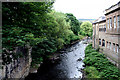
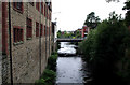
Photos of SK15 2QR


Area Information
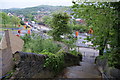
SK15 2QR represents a specific residential cluster within the Stalybridge postcode district, covering an area of 944 square metres and home to 1,559 residents. Living in this small, tightly defined community means you are part of a neighbourhood with a distinct character shaped by its density and location. The population density reaches 1,652,161 people per square kilometre, a figure that highlights the compact nature of this housing cluster compared to wider regional averages. You find yourself in an environment where daily interactions are close-knit due to the concentration of homes within such a limited footprint. The daily rhythm here is defined by proximity to broader transport and retail networks applicable to the wider SK15 postcode. While the immediate area is small, its connection to Stalybridge, Hyde, and the surrounding market towns ensures you do not miss out on regional facilities. The mix of housing and the specific age profile of the residents create a stable living environment. Prospective buyers should note that this postcode is a distinct entity within the larger South Manchester and Tameside housing market. It offers a contained living experience for those who prefer a defined residential zone while remaining connected to the wider commuter infrastructure serving Greater Manchester.
- Area Type
- Postcode
- Area Size
- 944 m²
- Population
- 1559
- Population Density
- 4949 people/km²
The property market in SK15 2 QR is characterised by a stock heavily weighted towards houses, as indicated by the data listing "Houses" as the predominant accommodation type. With 43% of the area classified as owner-occupied, this postcode functions more as an established residential zone than a high-turnover rental market. You will find that the housing stock here is likely motivated by buyers seeking detached or semi-detached family environments rather than investment flats or purpose-built rentals. This dynamic often results in a market where sellers are established owners looking to move after many years rather than estate agents flipping units for quick profit. For those considering homes in SK15 2QR, the high homeownership rate suggests a competitive market where properties may stay on the market longer while owners find the right replacement home. The specific nature of being a postcode covering a small residential cluster means supply is limited compared to broader districts. Buyers looking at this area should anticipate a process that mirrors established suburban neighbourhoods across Greater Manchester. The blend of a mix of family-sized homes and a significant portion of owner-occupiers creates a landscape where price stability and long-term value often take precedence over speculative gains. Understanding this local market rhythm is essential for anyone navigating property transactions here.
House Prices in SK15 2QR
No properties found in this postcode.
Energy Efficiency in SK15 2QR
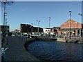
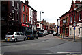
Residents of SK15 2QR enjoy convenient access to a variety of retail and transport options within practical reach. The nearest amenities include five notable retail locations such as Tesco Stalybridge, Aldi Stalybridge, and Spar Huddersfield. These shops provide daily necessities, groceries, and household goods without requiring a long journey into the city centre. If you require a broader selection, the area also offers five accessible rail stations, including Stalybridge Railway Station, Hyde North Railway Station, and Flowery Field Railway Station. This rail network connects you to major interchange points for travel across Greater Manchester and beyond. Metro connectivity is further supported by five nearby stops, including Ashton West, Ashton Moss, and Audenshaw, giving you flexible options for public transport journeys. The combination of supermarkets and multiple transport hubs means your daily errands and commutes can be managed efficiently from this postcode. You do not need to rely on a car for routine shopping or local travel, though the small size of the area (944 m²) requires planning for slightly longer trips to bigger facilities. Living in SK15 2QR offers a balanced lifestyle where modern convenience meets residential tranquility. The variety of amenities listed ensures that everything from a quick coffee to a week's worth of groceries is within easy reach.
Amenities
Schools
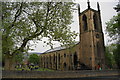
Families considering SK15 2QR will find St Paul's CofE Primary School, Stalybridge, serving as a key educational resource for the local community. This primary school holds a 'good' Ofsted rating, providing a level of quality assurance for parents enrolled in the area. The specific listing includes the school twice in the dataset, both times confirming its designation as a primary institution with this consistent rating. This establishment forms a central part of the local schooling ecosystem for children in the 30-64 age range demographic that predominates in the area. The presence of a rated primary school indicates that the immediate vicinity of SK15 2QR supports early years education, although secondary school options are not listed in the provided data. For residents decided to settle here, the proximity to St Paul's suggests a direct catchment link for younger children. The 'good' rating reflects a standard of education that meets national criteria, offering reassurance to families choosing homes in SK15 2QR. When selecting a property, you should verify the specific MAPA catchment areas for St Paul's CofE Primary School to ensure alignment with your own children's schooling needs. This school serves as a primary point of reference for educational quality in the neighbourhood.
| Rank | School | Type | Entry gender | Ages |
|---|
Explore more schools in this area
Go to Schools tabDemographics
The community in SK15 2QR is defined by an older demographic profile, with a median age of 47 years. The most common age range consists of adults between 30 and 64 years, indicating a settled population rather than a transient student or young professional demographic. This age distribution suggests a neighbourhood where many residents have established themselves and are likely in their family-forming or family-raising years. Homeownership stands at 43%, meaning nearly half of the residents own their homes outright or with a mortgage, while the remainder likely rents. Houses form the predominant accommodation type, reflecting a preference for traditional single-family living over apartment styles common in higher-density urban centres. The resident population is predominantly White, aligning with the broader demographic trends of the surrounding Stalybridge and Ashton areas. The low population density within this specific cluster does not isolate residents from the wider town, yet it fosters a quieter residential atmosphere compared to the town centre. Understanding these figures helps you picture a community of middle-aged homeowners and families seeking stability. The high proportion of homeowners and the age bracket of 30-64 years signal a stable social fabric where neighbours are likely to be long-term residents.
Household Size
Accommodation Type
Tenure
Ethnic Group
Religion
Household Composition
Age
Household Deprivation
NS-SEC
Explore more demographic insights in this area
Go to Demographics tabPlanning
Planning Constraints
- Flood RiskPremium
- Ramsar Wetland SitesPremium
- Area of Outstanding Natural BeautyPremium
- Protected Nature ReservePremium
- Protected WoodlandPremium