Area Overview for SK12 2AH
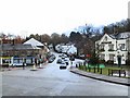
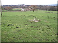
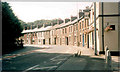
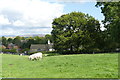
Photos of SK12 2AH


Area Information
The postcode SK12 2AH defines a very specific residential cluster within the Disley area of Cheshire. This 1.5 hectare site accommodates a population of 1,372 residents. The density of 90,812 people per square kilometre indicates a tightly packed neighbourhood where daily life involves close proximity to neighbours. Living in SK12 2AH means you reside in a contained environment where community interactions occur frequently on the street. This small footprint creates a distinct contrast to the sprawling suburbs often found elsewhere in the northwestern Midlands region. The area functions as a functional living space rather than a commercial or industrial zone. Your immediate surroundings are defined by residential boundaries rather than major transport corridors or business parks. This concentration of homes suggests a neighbourhood focused on settlement and stability. When you consider purchasing homes in SK12 2AH, you are entering a market where every property is part of a limited, identifiable group. The character of the place comes from this intentional clustering rather than expansion.
- Area Type
- Postcode
- Area Size
- 1.5 hectares
- Population
- 1372
- Population Density
- 1982 people/km²
The property market in SK12 2AH is characterised by a dominance of private ownership. With 76 per cent of households owning their homes, the local estate thrives on residents who have invested in property long term. The accommodation type is exclusively houses, which means you will not find flats or housing associations within this specific postcode boundary. This composition dictates the pricing dynamics and the type of buyers who engage with the local market. Purchasing in this area requires looking at a limited supply of houses due to the restrictive 1.5 hectare size of the cluster. The high home ownership rate suggests that transactions happen infrequently but with significant commitment from both buyers and sellers. This market is likely more stable than high-density rental areas because residents prioritize being in one location for decades. When searching for homes in SK12 2AH, you aim for a traditional family dwelling rather than an investment rental property. The lack of flats removes options for single occupants looking for smaller, lower-cost alternatives within this specific zone.
House Prices in SK12 2AH
Showing 23 properties
| Address | Type | Beds | Baths | Last Sale Price | Last Sale Date | |
|---|---|---|---|---|---|---|
| 2 St Marys Road, Disley, SK12 2AH | Semi-detached | 2 | 1 | £199,500 | Oct 2023 | |
| 24 St Marys Road, Disley, SK12 2AH | Semi-detached | 2 | 1 | £129,500 | Jun 2017 | |
| 4 St Marys Road, Disley, SK12 2AH | house | - | - | £150,000 | May 2016 | |
| 8 St Marys Road, Disley, SK12 2AH | Terraced | 2 | - | £113,250 | Jun 2014 | |
| 7 St Marys Road, Disley, SK12 2AH | house | - | - | £175,000 | Sep 2012 | |
| 16 St Marys Road, Disley, SK12 2AH | house | - | - | £140,000 | Sep 2009 | |
| 11 St Marys Road, Disley, SK12 2AH | house | 3 | 1 | £125,000 | Mar 2006 | |
| 14 St Marys Road, Disley, SK12 2AH | Semi-detached | - | - | £59,900 | May 2001 | |
| 12 St Marys Road, Disley, SK12 2AH | Semi-detached | - | - | £45,660 | Jun 1999 | |
| 1 St Marys Road, Disley, SK12 2AH | Semi-detached | 3 | - | £72,500 | Dec 1998 |
Energy Efficiency in SK12 2AH
Daily life in SK12 2AH benefits from a practical range of nearby amenities accessible within walking or short driving distance. Your nearest retail options include Co-op Disley, Spar High, and Spar, providing essential goods for household maintenance. Five retail outlets operate in the zone, ensuring you have local access to food and daily necessities without requiring long journeys. Transport links are equally proximate with five nearby rail stations. You can travel via Disley Railway Station, New Mills Newtown Railway Station, and Strines Railway Station to connect to wider networks. One airport, Manchester Woodford Airport, sits within practical reach for those requiring private flight access. This combination of shops and stations supports a self-sufficient lifestyle where you do not need to travel far for basic needs. The presence of multiple railway stations indicates good connectivity despite the small size of the residential cluster.
Amenities
Schools
Access to education for residents of SK12 2AH centres on one primary facility. Disley Primary School serves as the designated educational institution for this neighbourhood. The school operates at a primary level, catering to children from the early years up to the age of eleven. Since this is the only school listed in the immediate vicinity, families must travel further afield for secondary education. The proximity of Disley Primary School supports young families who value a short commute to their child's classroom. Parents living in SK12 2AH rely on this single facility for their younger children's schooling needs. The absence of other listed schools in the data indicates that this postcode cluster relies on a limited local supply. When planning your family's future, you must account for the travel distance to secondary venues beyond the immediate streets of this community.
| Rank | School | Type | Entry gender | Ages |
|---|
Explore more schools in this area
Go to Schools tabDemographics
The community profile of SK12 2AH shows a mature demographic structure. The median age calculation sits at 47 years, confirming that the most common age range comprises adults between 30 and 64 years old. This indicates a settlement built around mid-life workers and established families rather than young professionals or retirees. Home ownership stands at a solid 76 per cent, suggesting financial stability among the local residents. This high ownership rate points to long-term residents who have made a significant investment in their property. The housing stock consists primarily of houses, which aligns with the demographic preference for private gardens and separate living spaces. The predominant ethnic group identifies as White, reflecting the national average for this specific region of Cheshire. With over three quarters of residents owning their homes, the area has a settled character. This demographic profile suggests a quiet environment where families raise children and professionals work local jobs. The age distribution means that services must cater specifically to adult needs rather than the very young or elderly.
Household Size
Accommodation Type
Tenure
Ethnic Group
Religion
Household Composition
Age
Household Deprivation
NS-SEC
Explore more demographic insights in this area
Go to Demographics tabPlanning
Planning Constraints
- Flood RiskPremium
- Ramsar Wetland SitesPremium
- Area of Outstanding Natural BeautyPremium
- Protected Nature ReservePremium
- Protected WoodlandPremium