Area Overview for SK11 6YR
Photos of SK11 6YR


Area Information
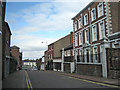
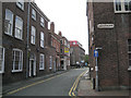
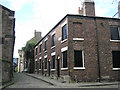
Living in SK11 6YR defines your experience of a compact, well-connected residential cluster in England. This specific postcode covers a small population of 1,437 residents, creating a intimate community feel where neighbours often know one another. The area sits firmly within the adult demographic, reflecting a stable environment shaped primarily by adults between the ages of 30 and 64. Unlike sprawling suburbs, SK11 6YR functions as a focused hub where daily life revolves around proximity to major transport links and local retail centres. Daily living in this postcode involves easy access to key services while retaining a distinct neighbourhood identity. You will find yourself in an area where high-speed digital infrastructure meets practical road connectivity. The concentration of homes in SK11 6YR suggests a reliable setting for families and professionals who seek stability without the anonymity of larger cities. Your routine benefits from being minutes away from three major railway stations and significant supermarket chains, ensuring that errands and commutes remain efficient. This residential cluster offers a straightforward package of convenience and community, making it a practical choice for those prioritising function and location over vast property estates.
- Area Type
- Postcode
- Area Size
- Not available
- Population
- 1437
- Population Density
- 11166 people/km²
The property market in SK11 6YR reflects a distinct owner-occupied character, excluding high-rise blocks or social housing estates from your considerations. With 58% of households being owner-occupied, you are navigating a market driven by long-term residents rather than transient renters. This high percentage of owner-occupiers typically results in slower but more deliberate turnover, favouring established families who have invested years into their homes within the postcode. When looking at homes in SK11 6YR, you will find houses to be the standard accommodation type, confirming the absence of apartments or flat developments in this specific cluster. This concentration of houses means buyers encounter properties suitable for those seeking space and privacy rather than urban density. The small population of 1,437 ensures that the local housing stock is finite, adding a layer of exclusivity to any available listings. Because the area functions as a residential cluster rather than a mixed-use development, pricing dynamics are likely influenced heavily by local school catchments and proximity to the nearby railway stations found in the wider district. You can expect a market where value is derived from the stability of tenure and the traditional nature of the housing stock, making SK11 6YR a pragmatic choice for those avoiding contesting rental markets or fragmented housing types.
House Prices in SK11 6YR
No properties found in this postcode.
Energy Efficiency in SK11 6YR
Your lifestyle in SK11 6YR is defined by immediate access to major retail and transport infrastructure, all within a short drive or walk. Ten notable supermarkets anchor the local trade, including Tesco Macclesfield, Aldi Macclesfield, and Asda Macclesfield. These three major retailers provide extensive grocery choices, ensuring you can complete all weekly shopping needs without travelling far. For those requiring broader transport options, four railway stations sit nearby, including Macclesfield Railway Station and Prestbury Railway Station, offering quick connections to the national network. Convenience also extends to business and travel, with Manchester Woodford Airport located within practical reach of residents. This aviation hub allows for easy scheduling of meetings or holidays without navigating traffic jams on Sundays. Shopping in this area is straightforward, with five key retail outlets available to serve the local population. The layout of SK11 6YR ensures that you rarely need to venture more than a few miles from home to access essential goods or services. This accessibility creates a balanced routine where leisure and utility coexist, allowing you to enjoy a home-based life while maintaining professional or social connections outside the immediate postcode.
Amenities
Schools
| Rank | School | Type | Entry gender | Ages |
|---|
Explore more schools in this area
Go to Schools tabDemographics
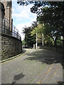
The community within SK11 6YR maintains a clear demographic focus, with the median age sitting at 47 years. You will find that the vast majority of residents fall into the adult age range of 30 to 64 years, creating a mature and stable local population. This age profile indicates a neighbourhood where long-term settlement is common, with fewer young children or retirees dominating the scene. Home ownership is the primary form of tenure, with 58% of households owning their property outright or with a mortgage. This high ownership rate contributes to a settled atmosphere where residents are likely to have deep roots in the locality. Accommodation in SK11 6YR consists almost exclusively of houses, shunning the high-rise apartments or bungalows found elsewhere. This housing stock aligns with the older resident profile and the preference for private gardens and detached structures. The predominant ethnic group is White, mirroring the national trend in many parts of Cheshire. Deprivation data, while not explicitly quantified in this specific dataset, suggests a safety score of 83 out of 100, indicating below-average crime rates. This low crime figure supports the observed stability of the area, where life proceeds without the interruptions often associated with higher crime zones.
Household Size
Accommodation Type
Tenure
Ethnic Group
Religion
Household Composition
Age
Household Deprivation
NS-SEC
Explore more demographic insights in this area
Go to Demographics tabPlanning
Planning Constraints
- Flood RiskPremium
- Ramsar Wetland SitesPremium
- Area of Outstanding Natural BeautyPremium
- Protected Nature ReservePremium
- Protected WoodlandPremium