Area Overview for SK10 2FJ
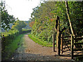
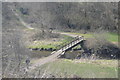
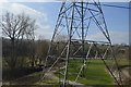
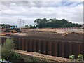
Photos of SK10 2FJ


Area Information
SK10 2FJ is a specific postcode area covering a small residential cluster within England. The population stands at 1,357 residents, creating a distinct neighbourhood rather than a sprawling suburb. Daily life here reflects the character of a settled community where people rely on local services and established travel routes. This location functions as a practical base for those seeking a quiet setting close to Macclesfield and its surrounding towns. Living in SK10 2FJ means being part of a defined group of households with strong ties to the area. The small population size suggests a quieter environment compared to larger urban districts, yet you remain within reach of essential amenities. Traffic volumes are likely moderate, supporting a pace of life that balances residential convenience with access to wider transport networks. This postcode represents a functional part of the greater Stockport and Cheshire landscape, offering stability for long-term residents. The area serves as a node for families and individuals who value proximity to retail and rail links without the density of city centres. You will find that the neighbourhood is integrated into the wider housing market of SK10, sharing characteristics with adjacent streets but maintaining its own identity as a specific cluster. Residents here benefit from established infrastructure that supports standard commuting patterns and local leisure activities. The setting avoids extreme planning constraints, allowing for straightforward access to surrounding areas.
- Area Type
- Postcode
- Area Size
- Not available
- Population
- 1357
- Population Density
- 2682 people/km²
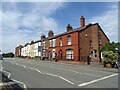
The property market in SK10 2FJ is defined by a significant owner-occupied presence. With 82 per cent of homes owned by their residents, the area functions largely as a static market where sales occur infrequently between long-term holders. This contrasts sharply with rental-heavy districts, creating an environment where property values reflect stability rather than speculative investment trends. Buyers seeking to enter this market will find a neighbourhood that has resisted recent waves of transient renting. Accommodation types in this postcode are almost exclusively houses. You will not encounter the uniform rows of flats or multi-unit dwellings common in more urbanised postcodes. This predominance of detached or semi-detached properties offers residents greater privacy and standalone ownership of their immediate surroundings. Homes in SK10 tend to be occupied by families or couples who require single-family structures rather than shared-entrance buildings. The housing stock here serves as a primary option for those prioritising traditional English residential architecture. When considering homes in SK10 2FJ, you are looking at a market where the majority of sellers are existing owners rather than property developers. This dynamic ensures that property designs and dimensions remain consistent with historical patterns of suburban development. The high ownership rate also suggests lower landlord premiums in transaction costs, though the initial purchase price may reflect the scarcity of available tenure.
House Prices in SK10 2FJ
No properties found in this postcode.
Energy Efficiency in SK10 2FJ
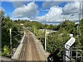
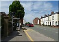
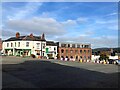
Living in SK10 2FJ places you within practical reach of five retail outlets for your daily shopping needs. You can visit Aldi Unit1 Barracks Mill Rp, Farmfoods Macclesfield, or Sainsburys Macclesfield for groceries and household essentials. This selection of supermarkets ensures that you do not need to travel far for fresh food or everyday items. The presence of these stores near the postcode supports a self-sufficient routine where most errands can be completed locally. Transport options extend beyond retail, with five railway stations positioned nearby. Macclesfield Railway Station, Prestbury Railway Station, and Adlington Railway Station form the backbone of your public transport network. These links facilitate easy access to larger towns and employment centres without requiring a personal vehicle for every journey. One airport facility, Manchester Woodford Airport, is also accessible, providing a point of connection for regional travel needs. The amenity mix focuses on practical necessities rather than extensive leisure complexes. While parks or cinemas are not listed among the nearest venues, the proximity to rail and major retailers like Sainsburys compensates for this. You can easily drive or take a train to access wider rural or urban attractions. The lifestyle here balances convenience with the need to travel slightly further for entertainment or extensive leisure activities. Residents appreciate the ability to handle daily tasks locally while keeping broader horizons open through rail connectivity.
Amenities
Schools
Families considering moving to SK10 2FJ will find two main educational institutions within reach. Tytherington High School operates as a primary school, catering to younger learners in the local community. For older students, Tytherington School functions as an academy, providing secondary education for children in the晟age group. The proximity of these two facilities means that a child can potentially grow up in the area without needing to move as they progress through their education. The presence of both a primary school and an academy addresses different stages of the curriculum under one local umbrella. While specific Ofsted ratings are not detailed in the available information, the existence of these designated schools provides a built-in infrastructure for education. Having a primary option nearby is particularly useful for parents of toddlers and infants, reducing the need for long commutes to larger town centres. Your child's education path in this neighbourhood is supported by established local provision rather than distant alternative arrangements. The mix of school types ensures that residents have access to a comprehensive school offering within a practical distance. You will find that local families are already integrated into the catchment areas of these institutions. This creates a continuum where siblings can attend the same educational ecosystem as their parents previously experienced.
| Rank | School | Type | Entry gender | Ages |
|---|
Explore more schools in this area
Go to Schools tabDemographics
The community in SK10 2FJ presents a clear age profile focused on adults between 30 and 64 years old. The median age is 47, indicating a mature population that has likely established careers and families. Most residents fall into the working-age bracket, suggesting a neighbourhood where financial stability is common among the householders. This age distribution influences local spending habits, with a higher reliance on adult-oriented services and sensible leisure options. Home ownership levels in this area reach 82 per cent. Such a high figure indicates that the majority of households have purchased their residences rather than renting. This stability often translates to longer residency periods, meaning neighbours tend to stay in their homes for many years. The housing stock consists primarily of houses, avoiding the prevalence of high-density flats or terraced units found in city cores. The population identifies predominantly as White, reflecting the national average for many parts of England. While the area lacks the large minority communities seen in some industrial hubs, it remains a representative slice of the wider county's demographic makeup. With over four-fifths of residents owning their homes, the atmosphere tends to be one of established permanence rather than transient living. You will find that social ties are deepened by shared ownership experiences and a lack of rental turnover volatility.
Household Size
Accommodation Type
Tenure
Ethnic Group
Religion
Household Composition
Age
Household Deprivation
NS-SEC
Explore more demographic insights in this area
Go to Demographics tabPlanning
Planning Constraints
- Flood RiskPremium
- Ramsar Wetland SitesPremium
- Area of Outstanding Natural BeautyPremium
- Protected Nature ReservePremium
- Protected WoodlandPremium