Area Overview for PR9 8HE
Photos of PR9 8HE

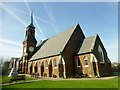
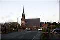
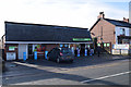
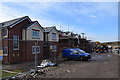
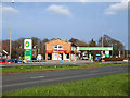
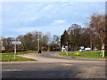
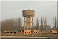
31 photos from this area
Area Information
Key information about the PR9 8HE including its size, population, and administrative classification.
- Area Type
- Postcode
- Area Size
- 3.0 hectares
- Population
- 1430
- Population Density
- 83 people/km²
House Prices in PR9 8HE
70
Properties
£131,489
Average Sold Price
£49,000
Lowest Price
£227,000
Highest Price
Showing 70 properties
| Address | Type | Beds | Baths | Last Sale Price | Last Sale Date | |
|---|---|---|---|---|---|---|
| 48 Fleetwood Drive, Banks, PR9 8HE | Semi-detached | 2 | 1 | £146,000 | Oct 2025 | |
| 40 Fleetwood Drive, Banks, PR9 8HE | Semi-detached | 3 | 1 | £200,000 | Mar 2025 | |
| 41 Fleetwood Drive, Banks, PR9 8HE | Semi-detached | 2 | 1 | £175,000 | Feb 2025 | |
| 15 Fleetwood Drive, Banks, PR9 8HE | Semi-detached | 4 | 1 | £227,000 | Jul 2023 | |
| 50 Fleetwood Drive, Banks, PR9 8HE | Bungalow | - | - | £145,000 | Mar 2023 | |
| 54 Fleetwood Drive, Banks, PR9 8HE | Semi-detached | 2 | 1 | £168,000 | Feb 2023 | |
| 75 Fleetwood Drive, Banks, PR9 8HE | Semi-detached | 2 | 1 | £163,000 | Jan 2023 | |
| 63 Fleetwood Drive, Banks, PR9 8HE | Retail | 2 | 1 | £136,000 | Jun 2022 | |
| 14 Fleetwood Drive, Banks, PR9 8HE | Retail | 3 | 1 | £185,000 | May 2022 | |
| 42 Fleetwood Drive, Banks, PR9 8HE | house | - | - | £215,000 | May 2022 |
Page 1 of 7
Energy Efficiency in PR9 8HE
Amenities
Schools
| Rank | School | Type | Entry gender | Ages |
|---|
Explore more schools in this area
Go to Schools tabDemographics
Household Size
Two person
most common
Accommodation Type
Houses
most common
Tenure
75
majority
Ethnic Group
White
most common
Religion
N/A
most common
Household Composition
N/A
most common
Age
47
median
Adults (30-64 years)
most common
Household Deprivation
N/A
with no deprivation
NS-SEC
26
in Lower managerial occupations
Explore more demographic insights in this area
Go to Demographics tabPlanning
Planning Constraints
- Flood RiskPremium
- Ramsar Wetland SitesPremium
- Area of Outstanding Natural BeautyPremium
- Protected Nature ReservePremium
- Protected WoodlandPremium