Area Overview for PR5 4HZ
Photos of PR5 4HZ

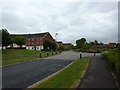
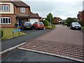

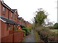


19 photos from this area
Area Information
Key information about the PR5 4HZ including its size, population, and administrative classification.
- Area Type
- Postcode
- Area Size
- 6411 m²
- Population
- 2187
- Population Density
- 3767 people/km²
House Prices in PR5 4HZ
26
Properties
£148,302
Average Sold Price
£67,950
Lowest Price
£224,000
Highest Price
Showing 26 properties
| Address | Type | Beds | Baths | Last Sale Price | Last Sale Date | |
|---|---|---|---|---|---|---|
| 7 Holland House Court, Walton Le Dale, PR5 4HZ | Terraced | 3 | 1 | £190,000 | Jun 2025 | |
| 8 Holland House Court, Walton Le Dale, PR5 4HZ | Terraced | 2 | 1 | £175,000 | Mar 2025 | |
| 23 Holland House Court, Walton Le Dale, PR5 4HZ | Semi-detached | 2 | 1 | £190,500 | Mar 2025 | |
| 4 Holland House Court, Walton Le Dale, PR5 4HZ | Semi-detached | 4 | 2 | £224,000 | Feb 2023 | |
| 18 Holland House Court, Walton Le Dale, PR5 4HZ | Terraced | 3 | 1 | £201,000 | Jan 2023 | |
| 17 Holland House Court, Walton Le Dale, PR5 4HZ | house | 4 | 2 | £210,000 | Aug 2022 | |
| 3 Holland House Court, Walton Le Dale, PR5 4HZ | Retail | 2 | 1 | £160,000 | Jun 2022 | |
| 20 Holland House Court, Walton Le Dale, PR5 4HZ | house | 2 | - | £132,000 | Mar 2019 | |
| 27 Holland House Court, Walton Le Dale, PR5 4HZ | Terraced | 3 | - | £158,250 | Aug 2018 | |
| 15 Holland House Court, Walton Le Dale, PR5 4HZ | Terraced | 3 | 1 | £149,000 | Jun 2018 |
Page 1 of 3
Energy Efficiency in PR5 4HZ
Amenities
Schools
| Rank | School | Type | Entry gender | Ages |
|---|
Explore more schools in this area
Go to Schools tabDemographics
Household Size
Family (3-5 people)
most common
Accommodation Type
Houses
most common
Tenure
87
majority
Ethnic Group
White
most common
Religion
N/A
most common
Household Composition
N/A
most common
Age
47
median
Adults (30-64 years)
most common
Household Deprivation
N/A
with no deprivation
NS-SEC
41
in Lower managerial occupations
Explore more demographic insights in this area
Go to Demographics tabPlanning
Planning Constraints
- Flood RiskPremium
- Ramsar Wetland SitesPremium
- Area of Outstanding Natural BeautyPremium
- Protected Nature ReservePremium
- Protected WoodlandPremium