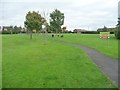
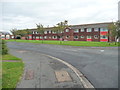
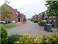
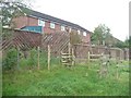
Area Overview for PR4 2XJ
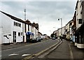
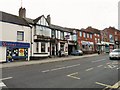
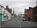
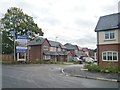
Photos of PR4 2XJ
Area Information
Pr4 2XJ represents a defined residential cluster within the wider Lancashire region, housing a population of 1,120 people. This postcode area is characterised by its small scale and focused community layout, making it a distinct choice for those seeking a specific neighbourhood feel. Living in PR4 2XJ involves relying on the local settlement dynamics of Kirkham and the immediate vicinity of Wesham. The area serves as a compact residential node where daily life revolves around proximity to established transport links and local shopping facilities. You will find that the environment is shaped by a high degree of stability, reflected in the long-term resident base. Homes in PR4 2XJ are situated within a setting that avoids significant planning constraints or environmental designations, allowing for straightforward local development decisions. The character of the area is defined by its function as a quiet, owner-occupied residential enclave rather than a bustling commercial hub. Residents here enjoy the benefits of established proximity to Kirkham railway station and nearby retail outlets without the noise of a town centre. This postcodes area offers a straightforward living experience where the focus remains on privacy and access to practical amenities rather than dramatic urban features. It is a place where the built environment is mature and the population is well-settled, providing a predictable backdrop for family life or retirement.
- Area Type
- Postcode
- Area Size
- Not available
- Population
- 1120
- Population Density
- 3096 people/km²
The property market in PR4 2XJ is dominated by private homeownership, with 92% of residents owning their homes outright or with a mortgage. This high ownership rate means that the area is not a lettings market but rather a place of long-term settlement. The accommodation type is exclusively houses, which shapes the physical landscape and the expectations for future purchases. When searching for homes in PR4 2XJ, you will encounter traditional family residences rather than purpose-built blocks of flats. This housing stock appeals to buyers who prioritise space and privacy over the convenience high-density living. The small population of 1,120 means the market moves slower than in larger urban centres, with fewer daily transactions. The local housing stock is mature, offering a consistent quality of accommodation without the experimental developments found in new-build estates. You will find that the area attracts buyers who have already maximised their career opportunities and are ready to downsize or remain in their current homes. The market is therefore driven by end-user demand rather than investor flippers looking for quick turnovers.
House Prices in PR4 2XJ
No properties found in this postcode.
Energy Efficiency in PR4 2XJ
Your daily life in PR4 2XJ will be shaped by immediate access to practical retail and transport options. You are within easy reach of Co-op Kirkham, Morrisons Kirkham, and the Co-op in Wesham for your shopping needs. This selection provides a solid baseline for daily groceries and essential household items. For travel, Kirkham & Wesham Railway Station, Salwick Railway Station, and Moss Side Railway Station offer multiple rail connections. These stations give you flexibility when commuting to larger destinations or travelling outside the region. Warton Airport is also nearby, providing an additional option for air travel if required. The proximity to these five retail outlets, five railway stations, and one airport ensures that you do not need to travel far for work, shop, or leisure. Living in PR4 2XJ means having a car is less critical than in more rural locations, though it remains useful for those trips. You will find that the local amenities are sufficient for a self-contained routine, reducing the time spent on commuting for basic necessities.
Amenities
Schools
Families living in PR4 2XJ have access to Kirkham St Michael's Church of England Primary School, which holds an Ofsted rating of Good. This is the primary educational option listed for the area, offering a definitive choice for early years education. The school's classification indicates that it meets rigorous standards for student outcomes and staff quality. There is no secondary school data provided for this specific postcode cluster, so parents must consider commuting to Kirkham or nearby towns for older children. The presence of a single primary school with a positive rating suggests a stable local education provision. You can rely on the school's rating when evaluating the area for young families who require local primary education. The Church of England denomination adds a specific ethos to the schooling environment, which may appeal to families within the Christian tradition. This limited but solid educational offering means residents are likely to support the school strongly. Educators and guardians in PR4 2XJ will prioritise ensuring children reach the benchmarks set by this Good-rated institution before transitioning to further education elsewhere.
| Rank | School | Type | Entry gender | Ages |
|---|
Explore more schools in this area
Go to Schools tabDemographics
The community in PR4 2XJ displays a clearly defined age profile, with a median age of 47 years. This statistic indicates that the residents are predominantly adults between the ages of 30 and 64. The demographic structure suggests a population that has moved beyond the early career stage and is typically looking for stability. House ownership stands at 92%, a figure that confirms this is overwhelmingly a settled, owner-occupied estate. Most households in PR4 2XJ live in houses rather than flats, reflecting a traditional suburban or semi-rural pattern of settlement. The predominant ethnic group in the area is White, which aligns with the broader demographic trends of the North West of England. This high level of home ownership and the dominance of the adult age group create a sense of established roots. You should expect a neighbourhood where neighbours have been in the area for many years. The lack of young families or transient student populations is notable here, contributing to a quieter atmosphere. These facts illustrate a community that values permanence, where the majority of residents have made significant long-term investments in their properties.
Household Size
Accommodation Type
Tenure
Ethnic Group
Religion
Household Composition
Age
Household Deprivation
NS-SEC
Explore more demographic insights in this area
Go to Demographics tabPlanning
Planning Constraints
- Flood RiskPremium
- Ramsar Wetland SitesPremium
- Area of Outstanding Natural BeautyPremium
- Protected Nature ReservePremium
- Protected WoodlandPremium