Area Overview for PR4 0TU
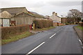
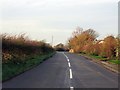
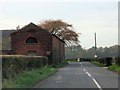
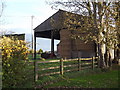
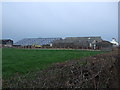
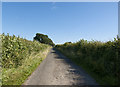
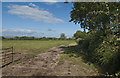
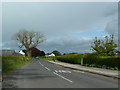
Photos of PR4 0TU

Area Information
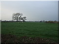
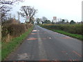
The postcode PR4 0TU sits within a specific residential cluster in Lancashire, covering an area of 31.3 hectares. With a population of 1,557 people, this neighbourhood feels manageable rather than sprawling. The density here stands at 107 people per square kilometre, which ensures you enjoy a semi-rural setting without being entirely isolated. Living in PR4 0TU means accessing a space defined by its mix of established homes and steady growth. You are not in a high-rise block or a gleaming new estate; you are in a defined zone where the community knows one another well. The geography is compact, making daily commutes simple and the sense of place strong. This area represents a slice of Lancashire life where residential homes dominate the landscape. The layout supports a lifestyle that values quiet streets and easy access to the surrounding countryside. When you visit PR4 0TU, you find a neighbourhood that functions as a complete unit rather than a collection of scattered dwellings. The scale is intimate enough that local issues, from waste collection to park maintenance, are handled with familiarity. It is a place where the daily rhythm of life is dictated more by the sun than by traffic jams. Your mornings start in a home surrounded by greenery or established gardens rather than construction dust. This postcode offers a grounded reality for those seeking a home in Lancashire without the noise and congestion of major cities. It is a straightforward choice for people who want stability and a clear view of their four walls.
- Area Type
- Postcode
- Area Size
- 31.3 hectares
- Population
- 1557
- Population Density
- 107 people/km²
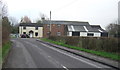
The housing market in PR4 0TU is characterised by a strong preference for permanent residence rather than renting. With an 88% home ownership rate, the area is overwhelmingly owner-occupied. This statistic tells you that the housing stock is stable and that landlords are a rare sight on these streets. The predominant accommodation type is houses, which includes detached, semi-detached, and terraced properties, though the density suggests a mix rather than a single estate. You are unlikely to find large apartment blocks here. Instead, the market consists of residential clusters built on mature land. This environment suits those who want to buy a family home where they can put down roots. The high ownership percentage implies that property values here reflect long-term investment rather than short-term speculation. Buyers looking at PR4 0TU should expect to find homes with established gardens and character features typical of Lancashire buildings. The low rental market share means you will not struggle with tenancy restrictions or landlord fees.transaction costs might be higher in some cases due to the age of some properties, but the stability is worth it. Seller motivation may vary, as many homeowners have lived here for years and are only selling if they need to move on. The market is not frenetic; it moves at a steady pace determined by genuine need. If you are looking for a property in this postcode, you will find an environment where the buyer truly owns the asset and the lifestyle that comes with it.
House Prices in PR4 0TU
Showing 4 properties
| Address | Type | Beds | Baths | Last Sale Price | Last Sale Date | |
|---|---|---|---|---|---|---|
| Poplar View, Hornby Lane, Inskip With Sowerby, PR4 0TU | Detached | - | - | - | - | |
| The Cottage, Hornby Lane, Inskip With Sowerby, PR4 0TU | Semi-detached | - | - | - | - | |
| Lambrigg, Hornby Lane, Inskip With Sowerby, PR4 0TU | house | - | - | - | - | |
| Throstle Nest Farm, Hornby Lane, Inskip With Sowerby, PR4 0TU | house | - | - | - | - |
Energy Efficiency in PR4 0TU
Daily life in PR4 0TU revolves around convenient access to essentials without the hassle of a busy town centre. Within practical reach of your home, you will find five retail options, including Spar, Aldi Kirkham, and another Spar outlet. These supermarkets and convenience stores are your primary destinations for groceries and household necessities. You do not need to drive far to stock your weekly shop or grab fresh produce. For those needing to travel slightly further, three railway stations are within easy reach: Kirkham & Wesham Railway Station, Salwick Railway Station, and Poulton. These stations provide vital links to Blackburn, Preston, and beyond. Commuters from PR4 0TU can start their day with a quick journey to a major city. The proximity to these transport hubs means you can work in a metropolitan office while living in a peaceful residential area. Beyond shopping and travel, the lifestyle is defined by the free air, green spaces, and low noise levels. The area is not known for nightlife or large leisure complexes, but it compensates with peace and value for money. You spend less time in traffic and more time at home or in nearby parks. The local shops and stations act as the arteries of a healthy, independent lifestyle. There is a practical charm to this setup where you have everything you need, but nothing is overwhelming or demanding your attention.
Amenities
Schools
Families living in PR4 0TU have several educational options nearby, with a strong emphasis on faith-based education. Two of the primary schools in the vicinity are rated 'good' by Ofsted: Inskip St Peter's Church of England Voluntary Aided School and Great Eccleston Copp CofE Primary School. Both schools offer a Christian foundation alongside a solid curriculum. A third option, St Mary's Catholic Primary School in Great Eccleston, serves the local Catholic community. Although this school's Ofsted rating is not listed in the provided information, it is a well-established institution in the area. The mix of Church of England and Catholic schools suggests a community that values religious education as part of its school choices. You will find no comprehensive secondary schools listed in the immediate vicinity of PR4 0TU, meaning older children likely travel to Kirkham or similar nearby towns for further education. For primary education, the ratings are reassuring. Inskip St Peter's and Great Eccleston Copp are reliable choices for parents who want a structured, values-driven environment. The presence of these schools ensures that young families do not need to commute far for their children's daily education. Transport links from PR4 0TU are sufficient to reach the secondary centres if needed, but the primary schools are central to your daily routine. The variety of denominations means you can choose a school that aligns with your faith or educational philosophy without leaving the PR4 0TU catchment radius.
| Rank | School | Type | Entry gender | Ages |
|---|
Explore more schools in this area
Go to Schools tabDemographics
The community in PR4 0TU reflects a mature and settled demographic rather than a student city or young professional hub. The median age of residents is 47, indicating a neighbourhood populated mainly by adults between the ages of 30 and 64. This age profile suggests families with children or individuals in their mid-career stages who have already secured their footing. You will find that most people at PR4 0TU have lived here for some time, creating a stable social fabric. Home ownership is extremely high in this area, with 88% of households owning their property outright or with a mortgage. This figure stands significantly above national averages and signals a society where financial security and long-term residence are the norm. The remaining 12% of households may be renting or living with relatives, contributing to a supportive network. Accommodation types are predominantly houses, meaning you will see detached and semi-detached properties forming the bulk of the streets. The population is overwhelmingly White, which aligns with the traditional demographic composition of much of rural and semi-rural Lancashire. There are no significant minority populations recorded in the data, meaning the cultural outlook is traditional and consistent with the region's history. You are looking at an area where neighbours have known each other for decades, not a rapidly changing community. The low turnover and high ownership rate mean you can trust that the people living near you are likely to stay. This stability appeals to buyers who value continuity over novelty. The demographic makeup confirms that this is a family-oriented zone rather than a hub for transient workers or digital nomads.
Household Size
Accommodation Type
Tenure
Ethnic Group
Religion
Household Composition
Age
Household Deprivation
NS-SEC
Explore more demographic insights in this area
Go to Demographics tabPlanning
Planning Constraints
- Flood RiskPremium
- Ramsar Wetland SitesPremium
- Area of Outstanding Natural BeautyPremium
- Protected Nature ReservePremium
- Protected WoodlandPremium