Area Overview for PR2 9GD
Photos of PR2 9GD


Area Information
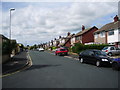
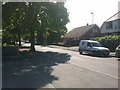
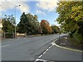
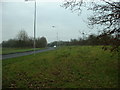
Living in PR2 9GD means residing within a specific postcode area that covers a small residential cluster in England. This pocket of Fulwood offers a distinct identity defined by its quiet, established nature rather than the bustle of a town centre. With a population of 1,318 people, the neighbourhood functions as a close-knit community where daily life moves at a steady pace. The area centres on houses, creating an environment that prioritises privacy and stability over the high-rise density found elsewhere. You will find this postcode to be a contained environment where neighbours know one another, yet the location remains connected to the wider transport network. The distinctiveness of PR2 9GD lies in its balance; it is a small, manageable cluster that avoids the congestion of major urban zones while maintaining access to essential services. For those seeking a home where the focus is on the property itself rather than proximity to nightlife or major shopping districts, this cluster provides a stable base. The area supports a settled lifestyle, offering a respite from the noise of larger urban centres while keeping key amenities within practical reach. This makes it a compelling option for anyone prioritising space and a lower-key atmosphere.
- Area Type
- Postcode
- Area Size
- Not available
- Population
- 1318
- Population Density
- 1329 people/km²
The property market in PR2 9GD is defined by a strong preference for ownership. With 78 per cent of homes owned outright, the area is not a hub for private rental schemes. This high ownership rate indicates a market where people buy to stay rather than to invest or rent temporarily. The accommodation type is strictly houses, which shapes the physical character of the neighbourhood. You will find detached or semi-detached family homes that suit the resident profile rather than apartments or converted flats. This limitation defines the housing stock; if you are seeking a flat, this postcode is not the location. The small size of the cluster, housing only 1,318 people, means very few properties are available at any given time. This scarcity can make the market feel tighter than in larger towns, but it also protects against rapid price fluctuations seen in high-demand rental sectors. For buyers, this means competition is likely limited to existing homeowners looking to upsize or move out of the area entirely. The stability of the stock suggests that maintenance costs are generally low compared to older city-centre flats. This area retains its value through consistent demand from those who want a house in a quiet setting.
House Prices in PR2 9GD
No properties found in this postcode.
Energy Efficiency in PR2 9GD
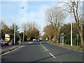
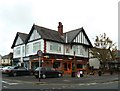
Daily life in PR2 9GD is supported by a compact range of amenities nearby. Within practical reach of your home, you have access to five retail locations. Notable shops include Booths Fulwood, M&S Royal Preston Hospital, and Aldi Fulwood. These outlets provide the basics for your weekly shop and general errands without requiring a significant journey into Preston. Residents can easily pick up groceries at Aldi or visit Booths for fresh food. The presence of M&S near the Royal Preston Hospital also indicates a convenience focus for the wider Fulwood area. For travel, four rail stations are located close by. You can catch a train at Preston Railway Station, Lostock Hall Railway Station, or Bamber Bridge Railway Station depending on your destination. These stations connect you to broader networks, meaning you are not isolated despite the low population. The lifestyle revolves around quiet suburbs and accessible services. You will find enough shops to meet your needs but lack the density of a full town centre. This balance ensures you have convenience without the constant noise and crowds. It is a practical neighbourhood where your essentials are always available, but the environment remains residential.
Amenities
Schools
Parents looking at PR2 9GD have a single educational option immediately nearby. The Derby School is the nearest facility, located within this cluster. It operates as a special school, catering to specific educational needs rather than the standard curriculum found in maintained comprehensive schools. There are no secondary or primary schools listed in the immediate vicinity of this postcode. This arrangement means families with children of typical school age must look beyond this specific cluster for day-to-day education. The presence of a special school suggests the neighbourhood supports a demographic that includes individuals with additional requirements. While the immediate area lacks standard primary or secondary provision, the location benefits from the convenience of having a specialist institution close by. Commuting to schools further away is common for families in this postcode, as the local offering is limited to this one singular institution. The absence of a range of options is a key factor for parents choosing homes here. They would need to factor in travel time to reach other educational establishments outside the PR2 9GD boundary.
| Rank | School | Type | Entry gender | Ages |
|---|
Explore more schools in this area
Go to Schools tabDemographics
The community in PR2 9GD reflects a settled, mature population. The median age is 47 years, indicating that most residents are well established in their adult lives. Adults aged between 30 and 64 years form the most common age range, creating a demographic profile typical of a stable, owner-occupied neighbourhood. Home ownership stands at 78 per cent, which is a significant proportion compared to the national average. This high rate of ownership suggests that the residents of PR2 9GD have primarily lived in these homes for a considerable period. The predominant ethnic group is White, mirroring the traditional character of many established areas in the region. Accommodation types are exclusively houses, meaning you will not find flats or converted buildings in this cluster. This aligns perfectly with the age profile, as older residents often prefer the space and independence provided by detached or semi-detached properties. The demographic data paints a picture of a neighbourhood where families and retirees have put down deep roots. There is very little turnover of young renters, and the population remains relatively static. This stability creates a predictable environment where local businesses and services can thrive without constantly adapting to shifting demographics. The community feels cohesive because the majority of homeowners have been in their properties for years.
Household Size
Accommodation Type
Tenure
Ethnic Group
Religion
Household Composition
Age
Household Deprivation
NS-SEC
Explore more demographic insights in this area
Go to Demographics tabPlanning
Planning Constraints
- Flood RiskPremium
- Ramsar Wetland SitesPremium
- Area of Outstanding Natural BeautyPremium
- Protected Nature ReservePremium
- Protected WoodlandPremium