Area Overview for PR2 2NH
Photos of PR2 2NH

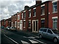
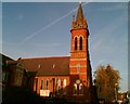
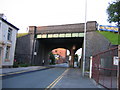
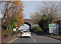
90 photos from this area
Area Information
Key information about the PR2 2NH including its size, population, and administrative classification.
- Area Type
- Postcode
- Area Size
- 8586 m²
- Population
- 2675
- Population Density
- 4025 people/km²
House Prices in PR2 2NH
41
Properties
£80,136
Average Sold Price
£31,000
Lowest Price
£127,500
Highest Price
Showing 41 properties
| Address | Type | Beds | Baths | Last Sale Price | Last Sale Date | |
|---|---|---|---|---|---|---|
| 249 Fylde Road, Preston, PR2 2NH | Terraced | 4 | 2 | £125,000 | Jul 2024 | |
| 283 Fylde Road, Preston, PR2 2NH | Terraced | 2 | 1 | £87,000 | Oct 2020 | |
| 281 Fylde Road, Preston, PR2 2NH | Terraced | 5 | 2 | £120,000 | Aug 2020 | |
| 275 Fylde Road, Preston, PR2 2NH | Terraced | 3 | 1 | £82,000 | Sep 2017 | |
| 289 Fylde Road, Preston, PR2 2NH | Terraced | 4 | 1 | £91,000 | Aug 2017 | |
| 285 Fylde Road, Preston, PR2 2NH | Terraced | 3 | 1 | £110,000 | Mar 2016 | |
| 273 Fylde Road, Preston, PR2 2NH | house | - | - | £65,000 | Mar 2016 | |
| 251 Fylde Road, Preston, PR2 2NH | house | - | - | £50,000 | Mar 2015 | |
| 279 Fylde Road, Preston, PR2 2NH | Terraced | 2 | - | £92,000 | Feb 2012 | |
| 287 Fylde Road, Preston, PR2 2NH | Terraced | 3 | 1 | £127,500 | Oct 2007 |
Page 1 of 5
Energy Efficiency in PR2 2NH
Amenities
Schools
| Rank | School | Type | Entry gender | Ages |
|---|
Explore more schools in this area
Go to Schools tabDemographics
Household Size
One person
most common
Accommodation Type
Houses
most common
Tenure
41
majority
Ethnic Group
White
most common
Religion
N/A
most common
Household Composition
N/A
most common
Age
22
median
Young Adults (15-29 years)
most common
Household Deprivation
N/A
with no deprivation
NS-SEC
11
in Lower managerial occupations
Explore more demographic insights in this area
Go to Demographics tabPlanning
Planning Constraints
- Flood RiskPremium
- Ramsar Wetland SitesPremium
- Area of Outstanding Natural BeautyPremium
- Protected Nature ReservePremium
- Protected WoodlandPremium