Area Overview for PR2 2AP
Photos of PR2 2AP

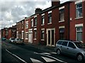
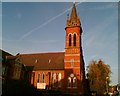
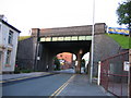
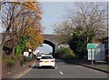
90 photos from this area
Area Information
Key information about the PR2 2AP including its size, population, and administrative classification.
- Area Type
- Postcode
- Area Size
- 5191 m²
- Population
- 1594
- Population Density
- 5508 people/km²
House Prices in PR2 2AP
45
Properties
£94,367
Average Sold Price
£30,000
Lowest Price
£165,000
Highest Price
Showing 45 properties
| Address | Type | Beds | Baths | Last Sale Price | Last Sale Date | |
|---|---|---|---|---|---|---|
| 177 De Lacy Street, Preston, PR2 2AP | Terraced | 3 | 1 | £120,000 | Jun 2025 | |
| 141 De Lacy Street, Preston, PR2 2AP | Terraced | 3 | 1 | £101,000 | May 2025 | |
| 165 De Lacy Street, Preston, PR2 2AP | Terraced | 3 | 1 | £102,000 | May 2025 | |
| 86 De Lacy Street, Preston, PR2 2AP | Terraced | 3 | 1 | £106,000 | Mar 2025 | |
| 179 De Lacy Street, Preston, PR2 2AP | Terraced | 3 | 1 | £95,000 | Jun 2024 | |
| 155 De Lacy Street, Preston, PR2 2AP | house | - | - | £120,000 | May 2024 | |
| 121 De Lacy Street, Preston, PR2 2AP | house | 3 | - | £110,000 | Sep 2022 | |
| 145 De Lacy Street, Preston, PR2 2AP | Terraced | 4 | 1 | £165,000 | May 2022 | |
| 147 De Lacy Street, Preston, PR2 2AP | house | 3 | - | £75,000 | Jul 2021 | |
| 133 De Lacy Street, Preston, PR2 2AP | Terraced | 3 | 1 | £106,000 | Dec 2020 |
Page 1 of 5
Energy Efficiency in PR2 2AP
Amenities
Schools
| Rank | School | Type | Entry gender | Ages |
|---|
Explore more schools in this area
Go to Schools tabDemographics
Household Size
One person
most common
Accommodation Type
Houses
most common
Tenure
52
majority
Ethnic Group
White
most common
Religion
N/A
most common
Household Composition
N/A
most common
Age
47
median
Adults (30-64 years)
most common
Household Deprivation
N/A
with no deprivation
NS-SEC
24
in Lower managerial occupations
Explore more demographic insights in this area
Go to Demographics tabPlanning
Planning Constraints
- Flood RiskPremium
- Ramsar Wetland SitesPremium
- Area of Outstanding Natural BeautyPremium
- Protected Nature ReservePremium
- Protected WoodlandPremium