Area Overview for PR2 1BH
Photos of PR2 1BH

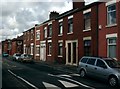

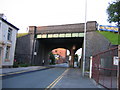
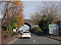
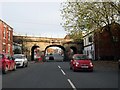
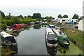
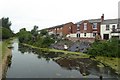
90 photos from this area
Area Information
Key information about the PR2 1BH including its size, population, and administrative classification.
- Area Type
- Postcode
- Area Size
- 3740 m²
- Population
- 1533
- Population Density
- 409925 people/km²
House Prices in PR2 1BH
18
Properties
£104,630
Average Sold Price
£49,000
Lowest Price
£155,000
Highest Price
Showing 18 properties
| Address | Type | Beds | Baths | Last Sale Price | Last Sale Date | |
|---|---|---|---|---|---|---|
| 65 Waterloo Road, Preston, PR2 1BH | Terraced | 3 | 1 | £150,000 | Oct 2025 | |
| 73 Waterloo Road, Preston, PR2 1BH | Terraced | 2 | 1 | £135,000 | Sep 2025 | |
| 93 Waterloo Road, Preston, PR2 1BH | Terraced | 7 | 2 | £155,000 | Feb 2024 | |
| 71 Waterloo Road, Preston, PR2 1BH | Terraced | 2 | - | £98,300 | Oct 2022 | |
| 69 Waterloo Road, Preston, PR2 1BH | house | - | - | £86,500 | Apr 2021 | |
| 63 Waterloo Road, Preston, PR2 1BH | Terraced | 2 | 1 | £90,000 | Sep 2018 | |
| 103 Waterloo Road, Preston, PR2 1BH | house | 4 | 4 | £130,000 | Jul 2018 | |
| 79 Waterloo Road, Preston, PR2 1BH | Terraced | 3 | 1 | £77,500 | Jul 2018 | |
| 105 Waterloo Road, Preston, PR2 1BH | house | 3 | - | £105,000 | Oct 2017 | |
| 67 Waterloo Road, Preston, PR2 1BH | Terraced | 2 | - | £89,950 | Mar 2014 |
Page 1 of 2
Energy Efficiency in PR2 1BH
Amenities
Schools
| Rank | School | Type | Entry gender | Ages |
|---|
Explore more schools in this area
Go to Schools tabDemographics
Household Size
One person
most common
Accommodation Type
Houses
most common
Tenure
45
majority
Ethnic Group
White
most common
Religion
N/A
most common
Household Composition
N/A
most common
Age
47
median
Adults (30-64 years)
most common
Household Deprivation
N/A
with no deprivation
NS-SEC
28
in Lower managerial occupations
Explore more demographic insights in this area
Go to Demographics tabPlanning
Planning Constraints
- Flood RiskPremium
- Ramsar Wetland SitesPremium
- Area of Outstanding Natural BeautyPremium
- Protected Nature ReservePremium
- Protected WoodlandPremium