Area Overview for Poynton East and Pott Shrigley Ward
Photos of Poynton East and Pott Shrigley Ward


Area Information
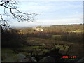
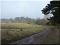
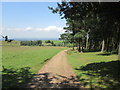
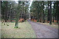
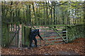
Living in Poynton East and Pott Shrigley Ward offers a specific residential experience within the Cheshire East district. This unitary authority ward sits on the easternmost fringe of the Cheshire Plain, encompassing the eastern portion of the town of Poynton. You will find that this area covers 34.4 km² and sits approximately 11 miles south-east of Manchester and 7 miles north of Macclesfield. The landscape shifts from predominantly residential zones in the west to increasingly rural character towards the east, bordering the former deer park of Lyme Hall. The community retains its identity as a former industrial centre, with a history rooted in coal mining that began in the 16th century. Development accelerated during the industrial era, with the arrival of railways in the mid-19th century transforming the local economy. Today, the parish benefits from proximity to major transport routes like the A6 trunk road and the Macclesfield Canal running along its eastern edge. The ward had a population of 7,501 as recorded in the 2021 Census, reflecting a stable, established settlement. Local landmarks include Poynton Pool, an ornamental lake created in the 1760s, and Saint George's Church, which houses the town's war memorial. This setting provides a balance of historic landmarks and green spaces, defining the daily rhythm of life for those choosing homes in Poynton East and Pott Shrigley Ward.
- Area Type
- District Borough Unitary Ward
- Area Size
- 34.4 km²
- Population
- Not available
- Population Density
- Not available
Demographics
The community in Poynton East and Pott Shrigley Ward demonstrates distinct demographic characteristics shaped by its local history. Your demographic profile reveals a median age of 70, indicating a population skewed significantly towards older residents. This age profile contrasts with many rapidly growing urban suburbs, suggesting a neighbourhood where long-term residents and retirees form the core of the community. The area recorded a total household composition and total accommodation type across its boundaries, providing a complete picture of living arrangements within this 34.4 km² footprint. Home ownership stands at an exceptionally high level of 88%, meaning most people living in Poynton East and Pott Shrigley Ward own their dwellings outright or with a significant mortgage rather than renting. This figure confirms the area functions primarily as a settled domestic base rather than a transient rental market. While specific data on ethnic diversity and religious adherence is not detailed in available sources, the high rate of owned property and the established nature of the civil parish suggest a traditional social fabric. The absence of younger age brackets and the dominance of owner-occupiers create a specific environment where neighbours often know one another across generations. You can expect a demographic landscape where stability and long-term residency define the social character of the ward.
Household Size
Accommodation Type
Tenure
Ethnic Group
Religion
Household Composition
Age
Household Deprivation
NS-SEC
Explore more demographic insights in this area
Go to Demographics tabPlanning
Planning Constraints
- Flood RiskPremium
- Ramsar Wetland SitesPremium
- Area of Outstanding Natural BeautyPremium
- Protected WoodlandPremium
- Crime RiskPremium