Area Overview for Pleasington
Photos of Pleasington


Area Information
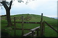
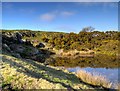
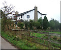
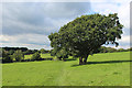
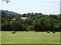
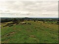
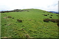
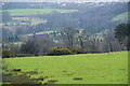
Pleasington is a civil parish located within the Borough of Blackburn with Darwen in Lancashire. This rural village sits on a hillside approximately 3 miles from Blackburn, positioning it as a pleasant suburb for those working in the town. The parish covers an area of 6.9 km² and sits above the River Darwen. Historical records note a population of around 1,074, which reflects a longstanding residential community. The area features a rural atmosphere characterised by its riverside setting and local history involving quarrying and farming. You will find old weavers' cottages and historic buildings such as the Pleasington Priory and Pleasington Old Hall. The locale offers a sense of tradition that dates back to the Domesday Book when it was first recorded as Plesigtune. Daily life here revolves around local landmarks including the Pleasington Golf Club and the football pitches opened in 1963. Residents enjoy direct access to walks along the River Darwen leading towards Witton Country Park. The village includes several public houses such as The Railway Hotel and The Butler's Arms where the community often gathers. This setting provides a quiet retreat while remaining close to the Argon a major local employer. You can explore the area's history by visiting sites like Feniscowles Hall or walking through the Pleasington Cemetery which features a Victorian walled garden.
- Area Type
- Parish
- Area Size
- 6.9 km²
- Population
- Not available
- Population Density
- Not available
Demographics
The community profile of Pleasington is defined by a significant proportion of older residents. The median age in the area stands at 70, indicating that the most common age group consists of elderly individuals. This demographic makes up a large portion of the local population compared to younger family households. Home ownership is the norm for residents in Pleasington, with 82 per cent of all homes owned outright or with a mortgage. This high figure suggests a stable resident base rather than a transient population of renters. The diversity of the area remains a standard feature of its composition, consistent with rural settlements in North West England. Family structures in the parish reflect the broader trends of a community settled over many generations. When considering the quality of life, the high rate of home ownership points to established roots rather than temporary accommodation. You can anticipate a neighbourhood where long-term residents dominate the streets. The age profile means that services catering to older adults may be more prevalent than those focused on children or young professionals. Understanding this demographic helps you assess whether the village matches your lifestyle expectations. The data confirms that Pleasington is a neighbourhood where older generations live alongside the history of the region.
Household Size
Accommodation Type
Tenure
Ethnic Group
Religion
Household Composition
Age
Household Deprivation
NS-SEC
Explore more demographic insights in this area
Go to Demographics tabPlanning
Planning Constraints
- Flood RiskPremium
- Ramsar Wetland SitesPremium
- Area of Outstanding Natural BeautyPremium
- Protected Nature ReservePremium
- Protected WoodlandPremium
- Crime RiskPremium