Area Overview for Oswaldtwistle
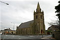
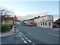
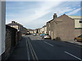
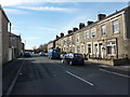
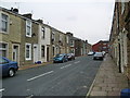
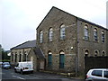
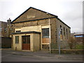
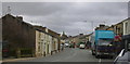
Photos of Oswaldtwistle


Area Information
Oswaldtwistle is a compact built-up area spanning 2.6 km², situated in England. Its population, while not explicitly stated, reflects a median age of 70, suggesting a community skewed towards older residents. This demographic shape influences the area’s character, with a focus on established living rather than rapid growth. The town is anchored by several primary schools, including Oswaldtwistle Moor End Primary School and St Andrew’s Church of England Primary School, all rated ‘good’ by Ofsted. These institutions, alongside nearby retail hubs like Heron Oswaldtwistle and Spar, provide essential services for daily life. Transport options are practical, with multiple railway stations within reach, including Church & Oswaldtwistle and Accrington, and a metro link to Rawtenstall. The area’s broadband score of 98 ensures reliable internet connectivity, supporting both home and work needs. Oswaldtwistle’s appeal lies in its balance of accessibility, community amenities, and a mature population profile, making it a viable choice for those seeking a settled, well-served environment.
- Area Type
- Built Up Area 250
- Area Size
- 2.6 km²
- Population
- Not available
- Population Density
- Not available
Oswaldtwistle’s lifestyle is shaped by its accessible amenities. Retail options include Heron Oswaldtwistle, Tesco, and Spar, offering everyday shopping needs within easy reach. The rail network, with stations at Church & Oswaldtwistle and Accrington, provides direct links to nearby towns, while the Rawtenstall metro connection expands travel possibilities. For leisure, the presence of multiple primary schools suggests community activity, though parks or recreational facilities are not detailed in the data. The area’s compact size ensures that essential services are within walking or short driving distance, fostering a sense of convenience. Residents can enjoy a mix of local shopping and transport options, supporting both daily errands and weekend excursions. This accessibility contributes to a practical, self-contained lifestyle, ideal for those valuing ease of movement and proximity to services.
Amenities
Schools
Oswaldtwistle is served by five primary schools, all catering to young families. These include Oswaldtwistle Moor End Primary School, Hippings Methodist Voluntary Controlled Primary School, and St Andrew’s and St Paul’s Church of England Primary Schools, each rated ‘good’ by Ofsted. The presence of multiple schools ensures options for parents, with a mix of state and church-affiliated institutions. This diversity allows families to choose between different educational philosophies and community ties. The high Ofsted ratings suggest consistent quality, though no secondary schools are listed in the data. For families prioritising education, the proximity of these schools is a significant advantage. However, the absence of secondary school information means prospective buyers should verify additional educational provisions beyond primary level. The schools’ ratings and variety make Oswaldtwistle an attractive choice for families seeking reliable early education.
| Rank | A + A* % | School | Type | Entry gender | Ages |
|---|---|---|---|---|---|
| 1 | N/A | Oswaldtwistle Moor End Primary School | primary | N/A | N/A |
| 2 | N/A | Oswaldtwistle West End Primary School | primary | N/A | N/A |
| 3 | N/A | Oswaldtwistle Hippings Methodist Voluntary Controlled Primary School | primary | N/A | N/A |
| 4 | N/A | Oswaldtwistle St Andrew's Church of England Primary School | primary | N/A | N/A |
| 5 | N/A | Oswaldtwistle St Paul's Church of England Primary School | primary | N/A | N/A |
Explore more schools in this area
Go to Schools tabDemographics
Oswaldtwistle’s population has a median age of 70, the highest in the dataset, indicating a community predominantly composed of older adults. This age profile shapes local dynamics, with a focus on services and infrastructure suited to this demographic. Home ownership stands at 64%, suggesting a stable housing market where many residents live in their own homes. The data does not specify household composition or ethnic diversity, but the ‘total’ designation for these categories implies a broad mix of family structures and backgrounds. The area’s accommodation types are similarly unspecified, though the high home ownership rate suggests a prevalence of owner-occupied properties. This demographic profile may influence local amenities, with services tailored to older residents. While no deprivation data is provided, the presence of multiple schools and retail options suggests a degree of self-sufficiency. For prospective buyers, understanding the age distribution is key to assessing compatibility with their lifestyle needs.
Household Size
Accommodation Type
Tenure
Ethnic Group
Religion
Household Composition
Age
Household Deprivation
NS-SEC
Explore more demographic insights in this area
Go to Demographics tabPlanning
Planning Constraints
- Crime RiskLocked