Area Overview for Ormside
Photos of Ormside


Area Information
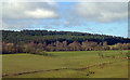
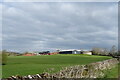
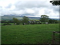
Great Ormside comprises a civil parish covering approximately 11 square kilometres in the heart of Cumbria. You are not buying into a bustling city; you are settling into a historic rural settlement defined by two distinct areas: the village of Great Ormside and the hamlet of Little Ormside. The parish sits just a few miles from the market town of Appleby-in-Westmorland, placing you within easy reach of local shops while retaining a secluded countryside atmosphere. Your daily life revolves around the River Eden, which flows close to the parish boundaries, and the quiet dominance of ancient stone architecture. St James' Church stands as a permanent fixture in Great Ormside, having been built during the 11th century. This ancient site anchors the community, reflecting a history that predates modern planning constraints. Nearby, Ormside Hall represents a significant 17th-century structure that incorporates the remains of a late medieval tower house. The area contains protected nature reserves and woodland, reminding residents that much of the landscape is preserved in its natural state. Living in Ormside means accepting a life governed by rural cycles rather than the fast pace of urban centres. The large acreage of your parish suggests spacious surroundings, but it also implies isolation from major infrastructure. You will find peace here, underpinned by a tangible sense of history and natural beauty.
- Area Type
- Parish
- Area Size
- 11.0 km²
- Population
- Not available
- Population Density
- Not available
Demographics
The community profile of Ormside points to a distinctly mature population. Data shows that the median age for residents is 70, indicating that the village serves primarily as a home for older generations. While specific breakdowns for every age bracket are not detailed, the overwhelming consensus is that 'Age: Total' represents the most common demographic range within the boundaries. This suggests a village where youth is less common and social life revolves around retirees seeking a quiet retirement setting. Home ownership is the dominant form of occupancy in this parish. Eighty per cent of households own their homes outright or with a mortgage, leaving only a minority of the population renting. This high level of ownership typically correlates with long-term stability and a deep-rooted connection to the local community. Regarding diversity, specific data on predominant ethnic groups, household composition, and religious affiliation is not explicitly provided in the available records. Consequently, you cannot verify the precise ethnic breakdown or exact religious affiliations of the parishioners. The lack of detailed diversity statistics should be noted when considering the social fabric, as it limits the ability to describe the specific cultural or faith-based makeup of the village. You are looking at a homogenous community structure defined almost entirely by age and tenure status rather than varied household compositions or broad demographic shifts.
Household Size
Accommodation Type
Tenure
Ethnic Group
Religion
Household Composition
Age
Household Deprivation
NS-SEC
Explore more demographic insights in this area
Go to Demographics tabPlanning
Planning Constraints
- Flood RiskPremium
- Ramsar Wetland SitesPremium
- Area of Outstanding Natural BeautyPremium
- Protected Nature ReservePremium
- Protected WoodlandPremium