Area Overview for OL8 2BA
Photos of OL8 2BA

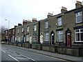
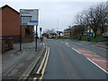
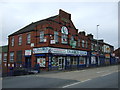
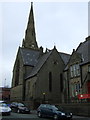
84 photos from this area
Area Information
Key information about the OL8 2BA including its size, population, and administrative classification.
- Area Type
- Postcode
- Area Size
- 1.9 hectares
- Population
- 2997
- Population Density
- 13427 people/km²
House Prices in OL8 2BA
36
Properties
£209,532
Average Sold Price
£21,052
Lowest Price
£450,000
Highest Price
Showing 36 properties
| Address | Type | Beds | Baths | Last Sale Price | Last Sale Date | |
|---|---|---|---|---|---|---|
| 89 Queens Road, Oldham, OL8 2BA | Semi-detached | 6 | 3 | £250,000 | Aug 2019 | |
| 91-93 Queens Road, Oldham, OL8 2BA | Land | - | - | £325,000 | Aug 2018 | |
| 95 Queens Road, Oldham, OL8 2BA | Semi-detached | - | - | £325,000 | Aug 2018 | |
| 69 Queens Road, Oldham, OL8 2BA | hospital_care_home | - | - | £400,000 | Oct 2016 | |
| 111 Queens Road, Oldham, OL8 2BA | house | 5 | - | £225,000 | Jan 2015 | |
| 65 Queens Road, Oldham, OL8 2BA | house | - | - | £250,000 | Jan 2014 | |
| 105 Queens Road, Oldham, OL8 2BA | house | - | - | £239,500 | Nov 2012 | |
| 83 Queens Road, Oldham, OL8 2BA | house | - | - | £390,000 | Oct 2010 | |
| 107 Queens Road, Oldham, OL8 2BA | house | - | - | £30,000 | Sep 2009 | |
| 97 Queens Road, Oldham, OL8 2BA | house | - | - | £250,000 | Apr 2007 |
Page 1 of 4
Energy Efficiency in OL8 2BA
Amenities
Schools
| Rank | School | Type | Entry gender | Ages |
|---|
Explore more schools in this area
Go to Schools tabDemographics
Household Size
Large (6+ people)
most common
Accommodation Type
Houses
most common
Tenure
60
majority
Ethnic Group
asian_total
most common
Religion
N/A
most common
Household Composition
N/A
most common
Age
22
median
Adults (30-64 years)
most common
Household Deprivation
N/A
with no deprivation
NS-SEC
11
in Lower managerial occupations
Explore more demographic insights in this area
Go to Demographics tabPlanning
Planning Constraints
- Flood RiskPremium
- Ramsar Wetland SitesPremium
- Area of Outstanding Natural BeautyPremium
- Protected Nature ReservePremium
- Protected WoodlandPremium