Area Overview for OL5 0NW
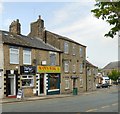
Photos of OL5 0NW


Area Information
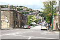
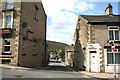
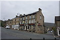
Living in OL5 0NW offers a specific type of residential experience within a small cluster that covers just 4353 square metres. With a population of 1807, this postcode represents a tightly knit environment where residents know one another well. The area is defined by its residential focus, providing a quiet backdrop for daily life away from the immediate busier roads of Stalybridge or Mossley. You will find that the neighbourhood character is established by existing homes rather than new developments, creating a settled atmosphere for those who prefer a stable community over rapid change. This small footprint means that practical access to surrounding towns is a key part of daily life, as the immediate surroundings offer limited space for large-scale leisure or retail expansion. For anyone considering homes in OL5 0NW, the primary appeal lies in the proximity to major transport hubs and established amenities. The area functions as a satellite settlement, relying on connectivity to the wider region for major services. Its size and population density suggest a environment where community interaction happens at a local level, making it a distinct option for buyers seeking a focused residential patch without the sprawl of larger towns.
- Area Type
- Postcode
- Area Size
- 4353 m²
- Population
- 1807
- Population Density
- 1344 people/km²
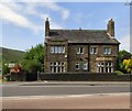
The property market in OL5 0NW is characterised by a strong presence of owner-occupiers, with 58 percent of homes in this postcode belonging to their occupants. This figure suggests a market driven by residents who have chosen to stay in the community rather than a high turnover of landlords or short-term tenants. Houses make up the primary accommodation type, indicating that the building stock consists of traditional single-family homes rather than apartment blocks. This structure appeals to buyers who value privacy and outdoor space, though it limits availability for those seeking flats. Given the small size of the area at 4353 square metres, the selection of homes is naturally restricted, and properties move relatively slowly compared to larger towns. You should expect a market where price remains stable due to local demand from the demographic living there. The high ownership rate implies that many of these homes have been in the same families for years, adding to the settled nature of the area. Potential buyers looking at homes in OL5 0NW will find a market dominated by existing stock rather than new builds, requiring patience and careful selection of the available options.
House Prices in OL5 0NW
Showing 5 properties
| Address | Type | Beds | Baths | Last Sale Price | Last Sale Date | |
|---|---|---|---|---|---|---|
| 4 Limefield, Mossley, OL5 0NW | Semi-detached | 3 | 1 | £174,500 | Mar 2024 | |
| 3 Limefield, Mossley, OL5 0NW | Semi-detached | 3 | 1 | £155,000 | Jan 2017 | |
| 5 Limefield, Mossley, OL5 0NW | house | - | - | £154,000 | Oct 2009 | |
| 2 Limefield, Mossley, OL5 0NW | Terraced | - | - | £59,000 | Feb 2001 | |
| 1 Limefield, Mossley, OL5 0NW | Terraced | - | - | £52,500 | Jan 1996 |
Energy Efficiency in OL5 0NW
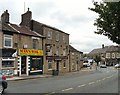
Residents of OL5 0NW benefit from immediate access to a range of practical amenities without needing to travel far. For your daily shopping needs, five retail outlets are within practical reach, including the Co-op Mossley, the Co-op The, and a Spar convenience store. These shops provide essentials and everyday items, reducing the need for long journeys just to buy groceries. Transport links are equally well integrated, with five railway stations serving the broader region. Mossley Railway Station and Greenfield Railway Station offer direct train access, while Stalybridge Railway Station serves wider travel routes. Additionally, five metro stops are available, such as Oldham Mumps, Oldham Central, and Derker, providing excellent public transport coverage. This network means you can reach major cities or other towns quickly using trains or the metro. The proximity of these stations enhances the convenience of living in OL5 0NW, allowing you to balance a local lifestyle with easy access to the wider metropolitan area. You can live a self-contained life here while retaining the freedom to commute or travel at short notice.
Amenities
Schools
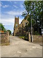
Families living near OL5 0NW have access to specific educational institutions that serve the local catchment. Livingstone Primary School is a nearby option with an Ofsted rating of good, providing a secure educational environment for primary age children. St George's CofE Primary School also serves the area, offering an alternative choice for families seeking a faith-based or community-linked education. You will have to research catchment zones to confirm which school a specific property assigns you to, as these institutions have defined boundaries. The availability of two primary options within reach means residents have some choice, though secondary school data is not present in the local overview. The presence of good-rated primary schools adds value to the area for families who prioritise educational quality. However, the absence of listed secondary schools in the immediate vicinity suggests that older children will need to travel further for their education. This mix of school types means the area is primarily suited for early childhood and pre-primary education stages, or for families already living there who have previously considered their schooling routes.
| Rank | School | Type | Entry gender | Ages |
|---|
Explore more schools in this area
Go to Schools tabDemographics
The community within OL5 0NW reflects an older demographic profile, with a median age of 47 years. Most residents fall into the adult bracket between 30 and 64 years old, indicating that this is not primarily a family destination for young children or a youth hub. Over half of the homes, representing 58 percent of households, are owner-occupied. This high ownership level suggests financial stability among residents and a preference for putting down roots in the area rather than renting. Houses form the predominant accommodation type, meaning you will find detached or semi-detached properties rather than flats or terraced terraces typical of high-density urban cores. The ethnic composition is predominantly White, contributing to a homogenous neighbourhood feel. These statistics paint a picture of a mature, established community where long-term residents are the majority. The lack of younger families correlates with the median age and the dominance of house ownership, indicating a demographic that has likely stayed in the area for a significant period. This stability shapes the local shops and services, which cater to the needs of a working-age adult population rather than a transient or youthful crowd.
Household Size
Accommodation Type
Tenure
Ethnic Group
Religion
Household Composition
Age
Household Deprivation
NS-SEC
Explore more demographic insights in this area
Go to Demographics tabPlanning
Planning Constraints
- Flood RiskPremium
- Ramsar Wetland SitesPremium
- Area of Outstanding Natural BeautyPremium
- Protected Nature ReservePremium
- Protected WoodlandPremium