Area Overview for OL5 0AT
Photos of OL5 0AT


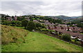
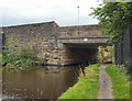
![Bottoms Bridge [no. 91] in OL5 0AT](https://images.propbar.co.uk/images/geograph/18/80/1880195_120.jpg)


Area Information
Living in OL5 0AT means residing within a very specific residential cluster in England. This postcode covers an extremely small area of just 42 square metres, a snapshot of a densely populated point within the wider OL5 region. The local population stands at 2,078 residents, creating a tight-knit environment where neighbours are likely to know one another. The density here is exceptionally high, reflecting a deep residential pocket rather than a broad suburb. For you, this translates to surroundings where every square inch is utilised for housing and community space. You will find that daily life is centred around the immediate proximity of neighbours and the shared infrastructure of this compact locality. There is no sprawling development here; instead, you are part of a focused community where the boundaries of the postcode define your entire immediate world. The character of this area is defined by its concentration, offering a sense of established living rather than new expansion. When you consider homes in OL5 0AT, you are entering a space where the volume of people packs closely together, shaping a distinct local atmosphere grounded in the reality of its limited size.
- Area Type
- Postcode
- Area Size
- 42 m²
- Population
- 2078
- Population Density
- 3957 people/km²
You will find that the property market in OL5 0AT is defined by a predominance of houses and a strong tradition of home ownership. With 56% of households in the postcode owning their property, this area leans heavily towards owner-occupiers rather than a rental sector. This statistic suggests a stable market where sellers have historically remained in their homes and built equity. The fact that houses form the main accommodation type means buyers looking for this locale will primarily encounter detached or semi-detached structures rather than converted flats or modern apartments. For someone considering homes in this specific cluster, the emphasis is on traditional housing stock suited to the local adult demographic. The small residential nature of the postcode means that supply is strictly limited, reinforcing the owner-occupied character. There are no indications of a volatile rental market here; instead, the data points to a settled environment where people buy with the intention of staying. If you are looking to purchase, you are entering a market driven by those who have already converted their homes from rented to owned dwellings.
House Prices in OL5 0AT
Showing 1 properties
| Address | Type | Beds | Baths | Last Sale Price | Last Sale Date | |
|---|---|---|---|---|---|---|
| 5 Back Cecil Street, Mossley, OL5 0AT | house | - | - | - | - |
Energy Efficiency in OL5 0AT
Your access to amenities in OL5 0AT relies on nearby facilities within practical reach, as the postcode itself represents a small residential cluster. You will find five railway stations close by, including Mossley Railway Station, Greenfield Railway Station, and Stalybridge Railway Station. These rail links provide essential connectivity to wider destinations. For shopping, you have access to five retail outlets, featuring well-known names such as Co-op Mossley, Spar, and Asda Ashton. These venues cover your daily essentials from groceries to household goods. Public transport is further supported by five metro stop options, including Ashton West, Oldham Mumps, and Oldham Central, ensuring you can travel beyond the local cluster without difficulty. You will also find five bus routes servicing the area, allowing flexibility for those without access to a private vehicle. Living in OL5 0AT offers a lifestyle where daily necessities are a short distance away, yet travel to broader towns remains efficient. The convenience of these specific venues supports a balanced routine where work, shopping, and leisure are all within a manageable commute.
Amenities
Schools
Education for families in OL5 0AT centres on just one primary institution within the immediate vicinity. St Joseph's RC Primary School stands as the key educational facility listed for this location. This school holds a Ofsted rating of good, which is the standard distinction awarded by the Department for Education to schools meeting consistent high standards. As a primary school, it serves children in their early years, aligning with the age profile of many residents in the area. The absence of secondary schools or other primary options in the provided data means thatOL5 0AT residents rely heavily on this single provision for the initial stage of their children's education. Families with primary-aged children will find their daily school run directly impacts the local community dynamics around this specific venue. The good rating provides reassurance regarding the quality of education you can expect for your children if they attend this establishment. It represents the sole formal educational anchor available within the documented scope for this postcode.
| Rank | School | Type | Entry gender | Ages |
|---|
Explore more schools in this area
Go to Schools tabDemographics
The community in OL5 0AT reflects a mature living pattern, centred largely on adults aged between 30 and 64 years. The median age of 47 confirms that this is an area populated by people who are well into adulthood, likely focusing on stability and long-term settlement. This age profile suggests a neighbourhood where residents are typically established in their careers and personal lives. Home ownership is a significant feature of this locality, with 56% of households owning their accommodation. This majority indicates a strong sense of rootedness among residents who have put down permanent stakes in the area. The predominant form of accommodation consists of houses, aligning with the demographic tendency for families or couples seeking private living space over shared flats. The ethnic composition of the area shows White residents as the predominant group. These demographic facts combine to paint a picture of a stable, owner-occupied community where the population has matured over time. Living in OL5 0AT means joining an environment defined by these long-term adult residents and their commitment to house ownership.
Household Size
Accommodation Type
Tenure
Ethnic Group
Religion
Household Composition
Age
Household Deprivation
NS-SEC
Explore more demographic insights in this area
Go to Demographics tabPlanning
Planning Constraints
- Flood RiskPremium
- Ramsar Wetland SitesPremium
- Area of Outstanding Natural BeautyPremium
- Protected Nature ReservePremium
- Protected WoodlandPremium