Area Overview for OL4 3JA
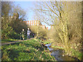
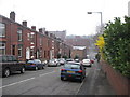
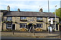
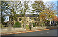
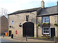
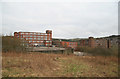
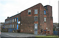
Photos of OL4 3JA


Area Information
OL4 3JA is a compact residential zone spanning just 1.6 hectares within Greater Manchester. This specific postcode cluster accommodates a population of 1,584 residents, creating a densely populated environment compared to the national average. Life here is defined by proximity; the area functions as a tight-knit residential neighbourhood rather than a sprawling district. You will find a community where homes are situated close together, fostering a sense of immediate local connection. Despite its small physical footprint, the area operates with the functionality of a larger locale, surrounded by shopping centres and railway stations within a short travel distance. The environment is strictly residential, offering a focus on private living rather than commercial business hubs. Residents navigate a landscape where utility and convenience take precedence over expansive green spaces or varied topography. For those considering buying or renting, the reality is a high-density setting where every square metre of land is utilised efficiently to house nearly 16,000 people per square kilometre. Daily life centres around accessibility to external amenities, requiring movement beyond the immediate 1.6 hectares of the postcode itself.
- Area Type
- Postcode
- Area Size
- 1.6 hectares
- Population
- 1584
- Population Density
- 3410 people/km²
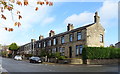
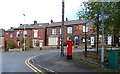
Homes in OL4 3JA are predominantly houses, forming the backbone of the 1.6 hectare residential cluster. With 44% of residents owning their homes, the area presents a mixed market where both buyers and renters find suitable options. This ownership rate suggests a community where long-term occupants value their investment, potentially leading to well-maintained housing stock. However, the remaining 56% of residents rely on rental accommodation, indicating a steady demand for private sector housing. Given the tiny size of the postcode, land supply is extremely limited, which may influence growth or expansion within the immediate area. The landscape is defined by these houses rather than a mix of flats or larger commercial properties. You should expect a traditional residential setting if you are looking at properties here. The high population density of 99,245 people per square kilometre means that while homes are houses, they are packed tightly together. This situation often results in smaller gardens or shared driveways. Buying in OL4 3JA offers entry into a mature, established home environment, though the lack of space for new developments is a defining characteristic of the local property market.
House Prices in OL4 3JA
No properties found in this postcode.
Energy Efficiency in OL4 3JA
Your daily routine in OL4 3JA revolves around a network of major retail parks and transit points just beyond the postcode boundary. You are in close reach of Asda Oldham, Aldi Athens Way, and Tesco Oldham, ensuring you have constant access to supermarkets. Shopping needs are easily met without requiring a long drive or significant travel time. For commuters, the transport connections are immediate and frequent. You can walk to or drive short distances to reach Derker, Oldham Mumps, Oldham Central, Greenfield Railway Station, Mossley Railway Station, or Mills Hill Railway Station. These hubs serve hundreds of thousands of passengers daily, linking OL4 3JA to the wider network. While the area itself lacks parks or leisure centres within the 1.6 hectares, the immediate surroundings provide ample facilities for dining and shopping. The proximity to these specific venues means your lifestyle is defined by convenience and accessibility rather than proximity to local green spaces. Residents rely on the surrounding towns for broader entertainment, but the core needs of food and transport are thoroughly served by the named amenities listed. This setup supports a car-dependent lifestyle where a short trip from your home gets you to major shopping opportunities or train platforms.
Amenities
Schools
| Rank | School | Type | Entry gender | Ages |
|---|
Explore more schools in this area
Go to Schools tabDemographics
The community within OL4 3JA reflects a mature demographic profile, anchored by adults aged between 30 and 64 years. The median age for residents is 47, indicating a neighbourhood settled by families and established households rather than young professionals or retirees. Home ownership stands at 44%, meaning roughly half of the occupants own their properties while the remainder likely rent their homes. The primary accommodation type consists of houses, shaping the physical layout of the 1.6 hectare zone. Ethnically, the predominant group is White, contributing to a homogenous community structure typical of many parts of Oldham. This age distribution supports local businesses that cater to working adults and families requiring reliable services. You will encounter a population that values stability, as evidenced by the significant proportion of owner-occupied homes. The demographic composition suggests a quiet atmosphere where residents are likely invested in their immediate surroundings. Understanding this age and ownership profile helps clarify who lives in OL4 3JA and what kind of community support networks might already be in place for neighbours in this specific postcode.
Household Size
Accommodation Type
Tenure
Ethnic Group
Religion
Household Composition
Age
Household Deprivation
NS-SEC
Explore more demographic insights in this area
Go to Demographics tabPlanning
Planning Constraints
- Flood RiskPremium
- Ramsar Wetland SitesPremium
- Area of Outstanding Natural BeautyPremium
- Protected Nature ReservePremium
- Protected WoodlandPremium