Area Overview for OL16 3LQ
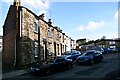
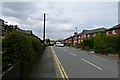
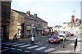
Photos of OL16 3LQ
Area Information
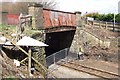
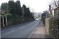
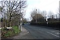
The postcode area OL16 3LQ represents a densely populated residential cluster within Greater Manchester. You live within a tiny footprint of just 1.4 hectares, where 1,528 residents call this small patch of land home. The population density is extraordinarily high at 111,949 people per square kilometre, creating an intense urban environment rather than a suburban street. This location is not a sprawling neighbourhood but a specific residential grouping situated near Milnrow and Kingsway Business Park. Daily life here is defined by immediate proximity to major transport hubs and employment zones. Residents navigate a compact environment where the boundary between the home and the wider town of Rochdale blurs quickly. Living in OL16 3LQ means you are part of a community where space is at a premium. The area functions as a node connecting commuters to Smithy Bridge, Rochdale, and Littleborough railway stations. Your daily routine likely involves short trips to nearby employment centres like Kingsway Business Park. The small scale of the area means you are never far from essential services or transport links, yet the high density means you share immediate surroundings with nearly a thousand neighbours. This concentrated living arrangement offers convenience but requires adaptation to a busy, close-knit rhythm. You are situated on the edge of Milnrow, balancing quiet residential moments with the noise of surrounding commercial activity.
- Area Type
- Postcode
- Area Size
- 1.4 hectares
- Population
- 1528
- Population Density
- 3286 people/km²
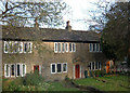
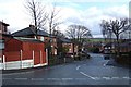
The housing market in OL16 3LQ is distinctly owner-occupier led. With 68 per cent of dwellings occupied by owners, you are looking at a traditional market where residents buy to stay. This is not a landlord-helmed rental estate but a collection of homes filled by families or individuals seeking root in the area. The predominant accommodation type is houses, meaning you will find detached or semi-detached properties rather than blocks of flats or purpose-built apartments. This housing style suits a high median age of 47, where households typically prefer single-family living over twinned units or high-rise flats. Homes in OL16 3LQ represent a specific segment of the Greater Manchester market. The small geographic size of 1.4 hectares limits the total number of properties available, making individual listings significant for local housing trends. Because the area is so compact, properties here act as gateways to the larger Milnrow and Rochdale markets. Buyers seeking houses in this specific postcode find a stock aligned with local demographic needs: solid, single-family dwellings. The high density of people living on this small land area does not result in a high-rise skyline but rather a tight concentration of existing houses. This suggests that finding a new build might be difficult, pushing interest toward the established stock. If you value a private garden or driveway, you are more likely to find it here than in a flat development.
House Prices in OL16 3LQ
No properties found in this postcode.
Energy Efficiency in OL16 3LQ
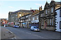
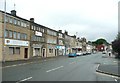
Your lifestyle in OL16 3LQ revolves around immediate accessibility to the wider amenities of Milnrow. You have five retail units within easy walking distance, anchored by specific venues like Co-op Milnrow, Aldi Milnrow, and Asda Milnrow. These supermarkets handle your weekly grocery requirements without the need for a long drive. For transport and employment access, you are centrally located near Kingsway Business Park and Newbold, areas that host numerous offices. The presence of five metro stops and five railway stations means you rarely need a car for short trips across the town. Regarding leisure and fresh air, the immediate 1.4 hectare zone does not contain large parks. However, the name OL16 3LQ places you on the doorstep of Milnrow's broader green spaces. Residents rely on the surrounding town for parks, sports facilities, and dining options found in the larger shopping precincts. You live in a practical neighbourhood where convenience is the primary design feature. The combination of nearby shopping, transport hubs, and office spaces creates a self-contained daily loop for most commuters. You shop locally, travel easily, and access work without extensive planning. This accessibility defines the character of life in this small residential cluster.
Amenities
Schools
| Rank | School | Type | Entry gender | Ages |
|---|
Explore more schools in this area
Go to Schools tabDemographics
The community living in OL16 3LQ is defined by a mature demographic profile. The median age of 47 years indicates a resident base that falls squarely within the adult working age range of 30 to 64 years. This age distribution suggests a neighbourhood dominated by established professionals rather than young families or retirees. With 68 per cent home ownership, the area feels stable and settled. A significant majority of adults in this postcode hold the keys to their own properties, creating a community invested in long-term stability rather than a transient rental population. Accommodation in OL16 3LQ consists primarily of houses, which contrasts with the high-density statistics caused by the very small land area available. You are purchasing or renting traditional housing stock rather than converting flats or terraced rows. The predominant ethnic group is White, reflecting the broad demographic character typical of the wider Oldham and Rochdale metropolitan area. This social makeup contributes to a cohesive community identity where neighbours tend to have deep roots in the region. The high home ownership rate combined with the age profile paints a picture of a reliable, property-owning community focused on the mid-life stage of adulthood. Living here offers the security of tenure that comes with such widespread ownership among the primary householders.
Household Size
Accommodation Type
Tenure
Ethnic Group
Religion
Household Composition
Age
Household Deprivation
NS-SEC
Explore more demographic insights in this area
Go to Demographics tabPlanning
Planning Constraints
- Flood RiskPremium
- Ramsar Wetland SitesPremium
- Area of Outstanding Natural BeautyPremium
- Protected Nature ReservePremium
- Protected WoodlandPremium