Area Overview for OL12 0DR
Photos of OL12 0DR

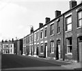
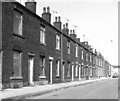
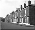
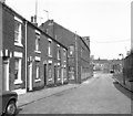
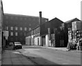
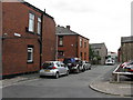
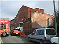
62 photos from this area
Area Information
Key information about the OL12 0DR including its size, population, and administrative classification.
- Area Type
- Postcode
- Area Size
- 3901 m²
- Population
- 1746
- Population Density
- 7411 people/km²
House Prices in OL12 0DR
12
Properties
£400,000
Average Sold Price
£400,000
Lowest Price
£400,000
Highest Price
Showing 12 properties
| Address | Type | Beds | Baths | Last Sale Price | Last Sale Date | |
|---|---|---|---|---|---|---|
| 183C Yorkshire Street, Rochdale, OL12 0DR | Terraced | - | - | £400,000 | May 2022 | |
| 173 Yorkshire Street, Rochdale, OL12 0DR | Terraced | - | - | - | - | |
| Ground Floor, 161 Yorkshire Street, Rochdale, OL12 0DR | Industrial | - | - | - | - | |
| Flat Over, 147 Yorkshire Street, Rochdale, OL12 0DR | Flat | - | - | - | - | |
| Adjacent, 147 Yorkshire Street, Rochdale, OL12 0DR | Industrial | - | - | - | - | |
| Clippers, 183A Yorkshire Street, Rochdale, OL12 0DR | office_workshop | - | - | - | - | |
| 161 Yorkshire Street, Rochdale, OL12 0DR | retail_financial | - | - | - | - | |
| Smash Official, 159 Yorkshire Street, Rochdale, OL12 0DR | retail_financial | - | - | - | - | |
| 169A Yorkshire Street, Rochdale, OL12 0DR | Terraced | - | - | - | - | |
| 159A Yorkshire Street, Rochdale, OL12 0DR | Industrial | - | - | - | - |
Page 1 of 2
Energy Efficiency in OL12 0DR
Amenities
Schools
| Rank | School | Type | Entry gender | Ages |
|---|
Explore more schools in this area
Go to Schools tabDemographics
Household Size
Family (3-5 people)
most common
Accommodation Type
Houses
most common
Tenure
41
majority
Ethnic Group
asian_total
most common
Religion
N/A
most common
Household Composition
N/A
most common
Age
47
median
Adults (30-64 years)
most common
Household Deprivation
N/A
with no deprivation
NS-SEC
12
in Lower managerial occupations
Explore more demographic insights in this area
Go to Demographics tabPlanning
Planning Constraints
- Flood RiskPremium
- Ramsar Wetland SitesPremium
- Area of Outstanding Natural BeautyPremium
- Protected Nature ReservePremium
- Protected WoodlandPremium