Area Overview for OL10 4BH
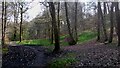
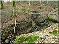
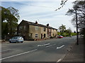
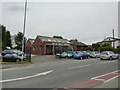
Photos of OL10 4BH
Area Information
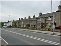
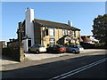
Living in OL10 4BH places you within a distinct residential cluster in Norden, a village situated on the western outskirts of Rochdale. This specific postcode covers a small population of 1,512 people across宽阔 acres of territory, resulting in a density of 77 people per square kilometre. The area is positioned along the A680 Edenfield Road, historically forming part of the Norden Ward within the Metropolitan Borough of Rochdale before the 1974 local government reorganisation. Today, residents enjoy a quiet existence away from the immediate commute of Manchester city centre, yet remain connected via ED70 Rosendale and Heywood. The community character is defined by its low population density and established history. The location was originally a chapelry in the ancient parish of Rochdale, receiving its own ecclesiastical identity in 1862 with the construction of a Grade II listed church. This historical backdrop contributes to a stable, long-term residential environment. The area functions as a self-contained neighbourhood where daily life revolves around proximity to key transport links rather than dense urban sprawl. You are in a setting where the pace of life is slower, characterised by static housing stock and a commitment to suburban tranquility. The geography ensures that while you are on the edge of the urban fringe, you retain access to the wider facilities of Rochdale and Heywood without living in their centres.
- Area Type
- Postcode
- Area Size
- Not available
- Population
- 1512
- Population Density
- 77 people/km²
The property landscape within OL10 4BH is dominated by houses, reflecting the rural origins of Norden. With 68% of the population consisting of homeowners, this postcode is firmly an owner-occupied market rather than a hub for private rentals or student housing. This statistic indicates that the housing stock consists principally of family-sized properties where occupants have a vested interest in long-term maintenance and neighbourhood upkeep. Buyers looking for homes in OL10 4BH will find a environment stabilised by tenure security. The low population density of 77 people per square kilometre further reinforces that the area is built around detached and semi-detached properties rather than terraced blocks or high rises. This type of accommodation suits those seeking privacy and garden space, aligning with the lifestyle of the 47-year median age resident. The specific nature of the postcode as a small residential cluster means there is limited land for new large-scale developments. Consequently, the housing market here relies on the existing supply of established properties. For buyers, this means competition centres on individual home conditions and locations within the cluster rather than district-wide availability. The high rate of ownership suggests properties are often sold through estate agents who maintain long-term market knowledge rather than short-term letting agents chasing turnover.
House Prices in OL10 4BH
No properties found in this postcode.
Energy Efficiency in OL10 4BH
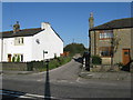
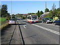
Daily life in OL10 4BH benefits from immediate access to major retail and transport hubs. Residents have five notable retail options within practical reach, including Iceland Heywood, Morrisons Heywood, and Tesco Heywood. These supermarkets provide a comprehensive range of groceries and household essentials, reducing the need to travel far for daily shopping. The area also offers five key metro connections and five railway stations, including Heywood and Castleton, facilitating easy access to the wider region. Beyond shopping and transit, the local environment includes St Paul's Church, a Grade II listed building constructed between 1860 and 1861. This historic landmark sits at the heart of the Norden community, offering a focal point for local heritage and architectural interest. The presence of these specific amenities suggests a lifestyle that balances suburban convenience with accessible greenways and local history. You can drive to Edenfield along the A680 or walk to the nearest supermarket, creating a balanced routine that avoids excessive commuting. The density of shops and stations ensures that while OL10 4BH remains a residential slice of Norden, it does not feel isolated. Your weekly routine involves easy access to quality food and essential services without leaving the immediate vicinity of the postcode.
Amenities
Schools
Education provision for families living in OL10 4BH is supported by nearby facilities with verified performance ratings. St Michael's Church of England Primary School in Bamford serves as the primary educational option for young children in the vicinity. This school holds an outstanding Ofsted rating, marking it as a top-performing institution for early years and primary education. The availability of an outstanding local primary school is a significant asset for parents weighing options for OL10 4BH as a family home. Secondary education options are not detailed in the immediate data for this specific postcode cluster, meaning families may need to consider travel time to schools outside the Norden Ward. The presence of St Michael's indicates a strong community investment in early childhood development. Living in OL10 4BH means your children can access a highly rated primary education without crossing significant administrative boundaries. The specific mention of Bamford confirms the school is a nearby neighbour, ensuring a manageable commute. For families relocating to this area, the proven track record of St Michael's provides a solid foundation for academic success. The lack of other listed schools in the immediate data suggests a catchment area focused on this single primary provider, with secondary choices likely drawn from the wider Rochdale borough network.
| Rank | School | Type | Entry gender | Ages |
|---|
Explore more schools in this area
Go to Schools tabDemographics
The community within OL10 4BH reflects a classic established neighbourhood in Greater Manchester. The median age stands at 47 years, indicating that the most common age range for residents consists of adults between 30 and 64 years. This demographic profile suggests the area is favoured by families and professionals nearing retirement rather than young singles or students. Home ownership is the defining characteristic of the local housing market, with 68% of residents owning their properties outright or with a mortgage. This high percentage points to an area of long-term stability where families have remained for decades, creating a deep-rooted sense of community. Accommodation in this postcode predominantly comprises houses, catering to family nuclei rather than high-density flats or student accommodation. The population is ethnically diverse, with White residents forming the predominant group. Deprivation metrics are not specified for this specific cluster in current datasets, but the high home ownership rate often correlates with lower levels of economic strain compared to rental-dense zones. The demographic skew towards older adults and families implies a demand for practical amenities like safe cycling routes and reliable public transport. You are entering a market defined by stability, where neighbours know each other and property values have historically ridden the wave of consistent demographic retention rather than rapid churn.
Household Size
Accommodation Type
Tenure
Ethnic Group
Religion
Household Composition
Age
Household Deprivation
NS-SEC
Explore more demographic insights in this area
Go to Demographics tabPlanning
Planning Constraints
- Flood RiskPremium
- Ramsar Wetland SitesPremium
- Area of Outstanding Natural BeautyPremium
- Protected Nature ReservePremium
- Protected WoodlandPremium