Area Overview for New Brighton Ward
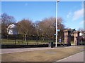
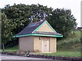
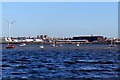
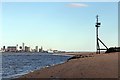
Photos of New Brighton Ward


Area Information
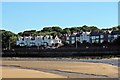
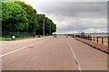
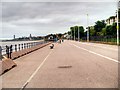
Living in New Brighton Ward offers a coastal lifestyle defined by its position at the mouth of the River Mersey. You reside within a 4.7 km² district unitary ward that forms part of Wallasey. The area combines historical significance with modern residential living, situated in the CH45 postcode area including CH45 1GB. This former smuggling and wrecking site now functions as a seaside resort modelled after Brighton, yet it retains distinct local character. The population stands at 5,991 people, creating a close-knit community rather than a sprawling suburb. You are surrounded by landmarks such as Perch Rock Battery, constructed between 1825 and 1829, and the New Brighton Lighthouse from 1827. Daily life here revolves around the area's longest promenade in the UK, which connects to Seacombe, and the history embedded in streets like Wellington Road, North Drive, and Montpellier Crescent. The location provides easy access to the Mersey waterfront while offering a quieter domestic environment compared to larger urban centres. Key attractions include the New Brighton Heritage and Information Centre, which documents the site's evolution from a 19th-century resort to its current state. You might find yourself walking past surviving Victorian villas or visiting the site where the Art Deco lido stood from 1934 until its demolition in 1990. The area remains a defined residential and leisure district, balancing commercial leisure history with quiet neighbourhood living. This unique blend of heritage sites and coastal positioning makes New Brighton Ward a distinctive choice for those seeking Merseyside living.
- Area Type
- District Borough Unitary Ward
- Area Size
- 4.7 km²
- Population
- 5991
- Population Density
- 1264 people/km²
Demographics
The community in New Brighton Ward presents a distinctly mature profile with a median age of 70. This demographic concentration suggests a resident base catering primarily to older adults or retirees. You are part of a neighbourhood where the most common age grouping spans the total population spectrum, though the high median age indicates fewer young families compared to urban districts. Home ownership sits at a robust 63%, meaning the majority of households own their property outright or with a mortgage rather than renting. This high ownership rate typically supports stable neighbourhood networks and lower turnover in the street. Accommodation types and household compositions reflect this older demographic, although specific breakdowns for each category are summarised under total records. The area contains a predominant ethnic group, religion figures, and diverse household structures recorded in the total dataset. Living here means engaging with a community where residents likely value established local amenities. The population density reaches 1,264 people per square kilometre, indicating a moderate level of urbanisation within this small 4.7 km² footprint. You are not dealing with the sparse isolation of rural life but also not experiencing the intense congestion of city centres. This density supports local services while maintaining a degree of spatial breathing room characteristic of a seaside ward.
Household Size
Accommodation Type
Tenure
Ethnic Group
Religion
Household Composition
Age
Household Deprivation
NS-SEC
Explore more demographic insights in this area
Go to Demographics tabPlanning
Planning Constraints
- Flood RiskPremium
- Ramsar Wetland SitesPremium
- Area of Outstanding Natural BeautyPremium
- Protected Nature ReservePremium
- Protected WoodlandPremium
- Crime RiskPremium