Area Overview for Mellor
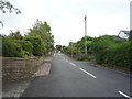
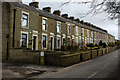
Photos of Mellor


Area Information
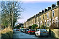
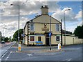
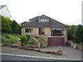
Mellor is a built-up area that serves as a residential hub for the wider region. This community covers 78.6 hectares and maintains a distinct character separate from larger urban centres. The area functions as a practical destination for those seeking a quieter lifestyle while remaining connected to surrounding services. You will find that daily life in Mellor revolves around local housing and essential amenities that are accessible from most streets. The footprint of the neighbourhood is significant enough to support a steady population without the density of a major city. Many residents choose this location because it offers a balance between suburban convenience and a smaller scale of development. The mix of houses forms a consistent neighbourhood identity that has evolved over recent decades. Whether you are evaluating homes in Mellor for a first purchase or a move after downsizing, the setting provides a stable environment. The area's layout supports a pace of life that prioritises quiet over high-speed urban activity. You are looking at a place where job commutes often extend beyond the immediate locality, but the local infrastructure tries to meet daily needs efficiently. The built environment here is defined by practicalities rather than grand planning, creating a lived-in atmosphere that suits long-term residents. The community in Mellor reflects the region's broader trend of an ageing population. The median age is 70 years, which means the typical resident is nearing retirement age or already retired. This demographic profile strongly influences the type of housing demand and the pace of local life. Most households in the area consist of older adults who have lived there for a considerable period. The home ownership rate stands at 84 per cent, indicating that the vast majority of families in Mellor own their properties outright or with a mortgage. Very few residents rent their homes, suggesting deep community roots and stability. Accommodation types align with this profile, favouring traditional houses suitable for established families or seniors. The limited presence of private renters means leases are less common than owner-occupied deeds. Diversity metrics and specific religious breakdowns are not detailed in current records for this specific postcode, but the social fabric appears cohesive around the dominant population groups. Deprivation indicators are not available in the current dataset, though low home ownership gaps suggest few struggling households. You are looking at a stable community where wealth is usually retained within family homes rather than passing through short-term tenancies. The age distribution drives a quiet, neighbourly environment where residents know one another through long-term residency rather than transient work forces. The property market in Mellor is defined by a strong predominance of owner-occupied homes. Eighty-four per cent of all households own their residence, creating a market where sales are driven by estate transfers rather than private rental turnover. This high ownership figure suggests that new buyers typically purchase established homes rather than allocating funds for service charges and tenancy rights. The local housing stock consists primarily of traditional residential properties, though specific current inventory levels are not detailed in the available records. Because rental demand is minimal, the competition is mainly between owner-occupiers moving up the chain or downsizing. You will find that buying a home in Mellor usually offers straightforward title transfers without the complexity of landlord-tenant disputes. The lack of significant private renting means that tenant restrictions are not a factor for purchasers. Accommodation types remain largely conventional, reflecting the historic nature of the built-up area. Potential buyers should expect to compete within a pool of wealthy, settled residents who value stability. The market does not fluctuate wildly because external investment is limited compared to high-growth rental zones. When you investigate homes in Mellor, you are entering a market where every sale represents either a family inheritance or a planned residential move. This stability benefits both sellers seeking consistency and buyers seeking long-term security. Families with school-aged children looking at Mellor have access to one specific local institution. Mellor St Mary Church of England Primary School is the designated primary option for residents in this community. The school holds a 'good' Ofsted rating, which categorises its performance as meeting the required standards for education and student welfare. This means you can expect a curriculum that adheres to national guidelines and a teaching staff that is competent in their roles. The school is the primary educational facility for young learners in the immediate vicinity of the homes. There are no secondary schools or colleges listed in the current data for Mellor, implying that older students likely travel to larger towns for further education. The presence of a single rated primary school indicates a fairly contained local education environment. You should verify catchment areas if you plan to move specifically for schooling reasons. The 'good' rating suggests a functional learning environment, though you may need to check nearby settlements for secondary options. This educational landscape supports families with younger children while requiring commutes for teenagers. The school's status as a Church of England institution may influence curriculum emphasis on religious education. Overall, the educational provision in Mellor is adequate for primary years but requires external links for secondary stages. Digital connectivity in Mellor presents a mixed picture for modern remote workers. Mobile network coverage scores highly at 83 out of 100, indicating excellent service for mobile phone calls and standard data usage while driving or walking. You can rely on strong mobile signals for navigation apps and urgent communication throughout the built-up area. However, fixed broadband quality scores much lower at 27 out of 100, which describes a poor connection for heavy internet tasks. This means streaming high-definition video or uploading large files to the cloud may result in slow speeds or buffering delays. Residents working from home might find this connectivity insufficient for video conferencing or cloud-based collaboration. The disparity between mobile and fixed networks suggests that the local infrastructure has not been fully upgraded for high-speed home internet. If reliable home Wi-Fi is your priority, you must investigate fibre installation options before committing to a property. The low broadband score could also impact smart home devices or live-streaming hobbies. While mobile coverage allows for good user access to the web on the go, stationary internet use remains a significant limitation. You should test the local fixed line speed if you consider homes in Mellor for regular remote work. The transport infrastructure does not currently support a fully digital-first lifestyle without additional personal investment in connectivity upgrades. Daily life in Mellor revolves around a handful of specific amenities that serve the immediate neighbourhood. For essentials, you have access to five retail outlets, including Spar stores and Morrisons Daily West End. These shops provide groceries and everyday necessities without the need to travel far. There are also five railway stations within practical reach, such as Ramsgreave and Wilpshire, Cherry Tree, and Pleasington stations. This network offers viable options for commuters needing to reach Manchester, Leeds, or other major hubs beyond the local area. You will find that shopping trips are quick due to the proximity of the Spar outlets and the discount supermarket. Dining extends beyond the immediate streets to nearby establishments that cater to the wider region. Leisure activities are not detailed in the local data, so you may need to drive to adjacent towns for cinemas or gyms. The railway connections allow you to maintain a rural feel while accessing the job markets of major cities. Shopping for clothes or household items involves visiting the local Spar or using the larger Morrisons location. The presence of multiple railway stations indicates good strategic positioning for regional travel. Residents can walk to the nearest Spar for milk and energy, making errands efficient. The combination of local shops and railway links creates a functional lifestyle that minimizes car dependency for short tasks. Commuters, however, will rely heavily on the regional train network for their daily work journeys. Safety assessments for Mellor indicate an environment with low crime risk. The area scores 79 out of 100 on a safety scale where higher numbers reflect lower crime rates. This places the neighbourhood well below the national average for criminal activity. You can feel assured that walking in the area at night carries a reduced risk of encountering offenders. The low crime risk designation suggests that police presence and community policing view this area as a priority to maintain order. Residents rarely report incidents of violence or burglary compared to urban districts or other built-up areas. The environment is conducive to outdoor activities during the evening without significant fear of personal harm. While no specific statistics on vehicle crime or anti-social behaviour are provided, the overall safety profile is positive. Security measures in homes in Mellor may be minimal because the threat level is perceived as low. Neighbours often know their neighbours better in an area where the police presence is less demanded. The safety score confirms that this is one of the safer places to reside in the North West region. Children can play outside with less supervision concerns than in high-crime zones. Overall, the area offers a peaceful atmosphere where residents can relax without constant vigilance. Who typically lives in Mellor and what is the community like? The community in Mellor is dominated by older residents, with a median age of 70 years. Home ownership is high at 84 per cent, meaning most families own their homes rather than renting. This creates a stable, settled environment where long-term residents form the core of the population. The area caters to retirees and established families rather than a transient workforce. What schools are available for children in Mellor? There is one primary school listed in the data: Mellor St Mary Church of England Primary School. It holds a 'good' Ofsted rating, indicating it meets national standards for education. Secondary school education requires travel to other towns, as no secondary institutions are listed for the area itself. How does the internet connection compare to other areas? Mobile coverage is strong, scoring 83 out of 100, which allows for reliable phone and mobile data usage. However, fixed broadband scores only 27 out of 100. This poor score means home internet speeds are likely very slow, making high-quality remote work or streaming difficult without additional upgrades. Can I easily get around and access shops and trains? Yes, practical amenities are close at hand. You can find five nearby shops including Spar and Morrisons Daily West End for groceries. Additionally, five railway stations are within reach, such as Ramsgreave & Wilpshire and Cherry Tree stations, providing good regional transport links for commuters. Is Mellor a safe place to live? Yes, the area is considered safe with a crime risk level marked as 'low'. It scores 79 out of 100 on a safety metric, which is an excellent result indicating below-average crime rates. You can expect a peaceful neighbourhood where residents rarely experience dangerous incidents.
- Area Type
- Built Up Area 250
- Area Size
- 78.6 hectares
- Population
- Not available
- Population Density
- Not available
Daily life in Mellor revolves around a handful of specific amenities that serve the immediate neighbourhood. For essentials, you have access to five retail outlets, including Spar stores and Morrisons Daily West End. These shops provide groceries and everyday necessities without the need to travel far. There are also five railway stations within practical reach, such as Ramsgreave and Wilpshire, Cherry Tree, and Pleasington stations. This network offers viable options for commuters needing to reach Manchester, Leeds, or other major hubs beyond the local area. You will find that shopping trips are quick due to the proximity of the Spar outlets and the discount supermarket. Dining extends beyond the immediate streets to nearby establishments that cater to the wider region. Leisure activities are not detailed in the local data, so you may need to drive to adjacent towns for cinemas or gyms. The railway connections allow you to maintain a rural feel while accessing the job markets of major cities. Shopping for clothes or household items involves visiting the local Spar or using the larger Morrisons location. The presence of multiple railway stations indicates good strategic positioning for regional travel. Residents can walk to the nearest Spar for milk and energy, making errands efficient. The combination of local shops and railway links creates a functional lifestyle that minimizes car dependency for short tasks. Commuters, however, will rely heavily on the regional train network for their daily work journeys. Safety assessments for Mellor indicate an environment with low crime risk. The area scores 79 out of 100 on a safety scale where higher numbers reflect lower crime rates. This places the neighbourhood well below the national average for criminal activity. You can feel assured that walking in the area at night carries a reduced risk of encountering offenders. The low crime risk designation suggests that police presence and community policing view this area as a priority to maintain order. Residents rarely report incidents of violence or burglary compared to urban districts or other built-up areas. The environment is conducive to outdoor activities during the evening without significant fear of personal harm. While no specific statistics on vehicle crime or anti-social behaviour are provided, the overall safety profile is positive. Security measures in homes in Mellor may be minimal because the threat level is perceived as low. Neighbours often know their neighbours better in an area where the police presence is less demanded. The safety score confirms that this is one of the safer places to reside in the North West region. Children can play outside with less supervision concerns than in high-crime zones. Overall, the area offers a peaceful atmosphere where residents can relax without constant vigilance. Who typically lives in Mellor and what is the community like? The community in Mellor is dominated by older residents, with a median age of 70 years. Home ownership is high at 84 per cent, meaning most families own their homes rather than renting. This creates a stable, settled environment where long-term residents form the core of the population. The area caters to retirees and established families rather than a transient workforce. What schools are available for children in Mellor? There is one primary school listed in the data: Mellor St Mary Church of England Primary School. It holds a 'good' Ofsted rating, indicating it meets national standards for education. Secondary school education requires travel to other towns, as no secondary institutions are listed for the area itself. How does the internet connection compare to other areas? Mobile coverage is strong, scoring 83 out of 100, which allows for reliable phone and mobile data usage. However, fixed broadband scores only 27 out of 100. This poor score means home internet speeds are likely very slow, making high-quality remote work or streaming difficult without additional upgrades. Can I easily get around and access shops and trains? Yes, practical amenities are close at hand. You can find five nearby shops including Spar and Morrisons Daily West End for groceries. Additionally, five railway stations are within reach, such as Ramsgreave & Wilpshire and Cherry Tree stations, providing good regional transport links for commuters. Is Mellor a safe place to live? Yes, the area is considered safe with a crime risk level marked as 'low'. It scores 79 out of 100 on a safety metric, which is an excellent result indicating below-average crime rates. You can expect a peaceful neighbourhood where residents rarely experience dangerous incidents.
Amenities
Schools
Families with school-aged children looking at Mellor have access to one specific local institution. Mellor St Mary Church of England Primary School is the designated primary option for residents in this community. The school holds a 'good' Ofsted rating, which categorises its performance as meeting the required standards for education and student welfare. This means you can expect a curriculum that adheres to national guidelines and a teaching staff that is competent in their roles. The school is the primary educational facility for young learners in the immediate vicinity of the homes. There are no secondary schools or colleges listed in the current data for Mellor, implying that older students likely travel to larger towns for further education. The presence of a single rated primary school indicates a fairly contained local education environment. You should verify catchment areas if you plan to move specifically for schooling reasons. The 'good' rating suggests a functional learning environment, though you may need to check nearby settlements for secondary options. This educational landscape supports families with younger children while requiring commutes for teenagers. The school's status as a Church of England institution may influence curriculum emphasis on religious education. Overall, the educational provision in Mellor is adequate for primary years but requires external links for secondary stages. Digital connectivity in Mellor presents a mixed picture for modern remote workers. Mobile network coverage scores highly at 83 out of 100, indicating excellent service for mobile phone calls and standard data usage while driving or walking. You can rely on strong mobile signals for navigation apps and urgent communication throughout the built-up area. However, fixed broadband quality scores much lower at 27 out of 100, which describes a poor connection for heavy internet tasks. This means streaming high-definition video or uploading large files to the cloud may result in slow speeds or buffering delays. Residents working from home might find this connectivity insufficient for video conferencing or cloud-based collaboration. The disparity between mobile and fixed networks suggests that the local infrastructure has not been fully upgraded for high-speed home internet. If reliable home Wi-Fi is your priority, you must investigate fibre installation options before committing to a property. The low broadband score could also impact smart home devices or live-streaming hobbies. While mobile coverage allows for good user access to the web on the go, stationary internet use remains a significant limitation. You should test the local fixed line speed if you consider homes in Mellor for regular remote work. The transport infrastructure does not currently support a fully digital-first lifestyle without additional personal investment in connectivity upgrades. Daily life in Mellor revolves around a handful of specific amenities that serve the immediate neighbourhood. For essentials, you have access to five retail outlets, including Spar stores and Morrisons Daily West End. These shops provide groceries and everyday necessities without the need to travel far. There are also five railway stations within practical reach, such as Ramsgreave and Wilpshire, Cherry Tree, and Pleasington stations. This network offers viable options for commuters needing to reach Manchester, Leeds, or other major hubs beyond the local area. You will find that shopping trips are quick due to the proximity of the Spar outlets and the discount supermarket. Dining extends beyond the immediate streets to nearby establishments that cater to the wider region. Leisure activities are not detailed in the local data, so you may need to drive to adjacent towns for cinemas or gyms. The railway connections allow you to maintain a rural feel while accessing the job markets of major cities. Shopping for clothes or household items involves visiting the local Spar or using the larger Morrisons location. The presence of multiple railway stations indicates good strategic positioning for regional travel. Residents can walk to the nearest Spar for milk and energy, making errands efficient. The combination of local shops and railway links creates a functional lifestyle that minimizes car dependency for short tasks. Commuters, however, will rely heavily on the regional train network for their daily work journeys. Safety assessments for Mellor indicate an environment with low crime risk. The area scores 79 out of 100 on a safety scale where higher numbers reflect lower crime rates. This places the neighbourhood well below the national average for criminal activity. You can feel assured that walking in the area at night carries a reduced risk of encountering offenders. The low crime risk designation suggests that police presence and community policing view this area as a priority to maintain order. Residents rarely report incidents of violence or burglary compared to urban districts or other built-up areas. The environment is conducive to outdoor activities during the evening without significant fear of personal harm. While no specific statistics on vehicle crime or anti-social behaviour are provided, the overall safety profile is positive. Security measures in homes in Mellor may be minimal because the threat level is perceived as low. Neighbours often know their neighbours better in an area where the police presence is less demanded. The safety score confirms that this is one of the safer places to reside in the North West region. Children can play outside with less supervision concerns than in high-crime zones. Overall, the area offers a peaceful atmosphere where residents can relax without constant vigilance. Who typically lives in Mellor and what is the community like? The community in Mellor is dominated by older residents, with a median age of 70 years. Home ownership is high at 84 per cent, meaning most families own their homes rather than renting. This creates a stable, settled environment where long-term residents form the core of the population. The area caters to retirees and established families rather than a transient workforce. What schools are available for children in Mellor? There is one primary school listed in the data: Mellor St Mary Church of England Primary School. It holds a 'good' Ofsted rating, indicating it meets national standards for education. Secondary school education requires travel to other towns, as no secondary institutions are listed for the area itself. How does the internet connection compare to other areas? Mobile coverage is strong, scoring 83 out of 100, which allows for reliable phone and mobile data usage. However, fixed broadband scores only 27 out of 100. This poor score means home internet speeds are likely very slow, making high-quality remote work or streaming difficult without additional upgrades. Can I easily get around and access shops and trains? Yes, practical amenities are close at hand. You can find five nearby shops including Spar and Morrisons Daily West End for groceries. Additionally, five railway stations are within reach, such as Ramsgreave & Wilpshire and Cherry Tree stations, providing good regional transport links for commuters. Is Mellor a safe place to live? Yes, the area is considered safe with a crime risk level marked as 'low'. It scores 79 out of 100 on a safety metric, which is an excellent result indicating below-average crime rates. You can expect a peaceful neighbourhood where residents rarely experience dangerous incidents.
| Rank | School | Type | Entry gender | Ages |
|---|
Explore more schools in this area
Go to Schools tabDemographics
The community in Mellor reflects the region's broader trend of an ageing population. The median age is 70 years, which means the typical resident is nearing retirement age or already retired. This demographic profile strongly influences the type of housing demand and the pace of local life. Most households in the area consist of older adults who have lived there for a considerable period. The home ownership rate stands at 84 per cent, indicating that the vast majority of families in Mellor own their properties outright or with a mortgage. Very few residents rent their homes, suggesting deep community roots and stability. Accommodation types align with this profile, favouring traditional houses suitable for established families or seniors. The limited presence of private renters means leases are less common than owner-occupied deeds. Diversity metrics and specific religious breakdowns are not detailed in current records for this specific postcode, but the social fabric appears cohesive around the dominant population groups. Deprivation indicators are not available in the current dataset, though low home ownership gaps suggest few struggling households. You are looking at a stable community where wealth is usually retained within family homes rather than passing through short-term tenancies. The age distribution drives a quiet, neighbourly environment where residents know one another through long-term residency rather than transient work forces. The property market in Mellor is defined by a strong predominance of owner-occupied homes. Eighty-four per cent of all households own their residence, creating a market where sales are driven by estate transfers rather than private rental turnover. This high ownership figure suggests that new buyers typically purchase established homes rather than allocating funds for service charges and tenancy rights. The local housing stock consists primarily of traditional residential properties, though specific current inventory levels are not detailed in the available records. Because rental demand is minimal, the competition is mainly between owner-occupiers moving up the chain or downsizing. You will find that buying a home in Mellor usually offers straightforward title transfers without the complexity of landlord-tenant disputes. The lack of significant private renting means that tenant restrictions are not a factor for purchasers. Accommodation types remain largely conventional, reflecting the historic nature of the built-up area. Potential buyers should expect to compete within a pool of wealthy, settled residents who value stability. The market does not fluctuate wildly because external investment is limited compared to high-growth rental zones. When you investigate homes in Mellor, you are entering a market where every sale represents either a family inheritance or a planned residential move. This stability benefits both sellers seeking consistency and buyers seeking long-term security. Families with school-aged children looking at Mellor have access to one specific local institution. Mellor St Mary Church of England Primary School is the designated primary option for residents in this community. The school holds a 'good' Ofsted rating, which categorises its performance as meeting the required standards for education and student welfare. This means you can expect a curriculum that adheres to national guidelines and a teaching staff that is competent in their roles. The school is the primary educational facility for young learners in the immediate vicinity of the homes. There are no secondary schools or colleges listed in the current data for Mellor, implying that older students likely travel to larger towns for further education. The presence of a single rated primary school indicates a fairly contained local education environment. You should verify catchment areas if you plan to move specifically for schooling reasons. The 'good' rating suggests a functional learning environment, though you may need to check nearby settlements for secondary options. This educational landscape supports families with younger children while requiring commutes for teenagers. The school's status as a Church of England institution may influence curriculum emphasis on religious education. Overall, the educational provision in Mellor is adequate for primary years but requires external links for secondary stages. Digital connectivity in Mellor presents a mixed picture for modern remote workers. Mobile network coverage scores highly at 83 out of 100, indicating excellent service for mobile phone calls and standard data usage while driving or walking. You can rely on strong mobile signals for navigation apps and urgent communication throughout the built-up area. However, fixed broadband quality scores much lower at 27 out of 100, which describes a poor connection for heavy internet tasks. This means streaming high-definition video or uploading large files to the cloud may result in slow speeds or buffering delays. Residents working from home might find this connectivity insufficient for video conferencing or cloud-based collaboration. The disparity between mobile and fixed networks suggests that the local infrastructure has not been fully upgraded for high-speed home internet. If reliable home Wi-Fi is your priority, you must investigate fibre installation options before committing to a property. The low broadband score could also impact smart home devices or live-streaming hobbies. While mobile coverage allows for good user access to the web on the go, stationary internet use remains a significant limitation. You should test the local fixed line speed if you consider homes in Mellor for regular remote work. The transport infrastructure does not currently support a fully digital-first lifestyle without additional personal investment in connectivity upgrades. Daily life in Mellor revolves around a handful of specific amenities that serve the immediate neighbourhood. For essentials, you have access to five retail outlets, including Spar stores and Morrisons Daily West End. These shops provide groceries and everyday necessities without the need to travel far. There are also five railway stations within practical reach, such as Ramsgreave and Wilpshire, Cherry Tree, and Pleasington stations. This network offers viable options for commuters needing to reach Manchester, Leeds, or other major hubs beyond the local area. You will find that shopping trips are quick due to the proximity of the Spar outlets and the discount supermarket. Dining extends beyond the immediate streets to nearby establishments that cater to the wider region. Leisure activities are not detailed in the local data, so you may need to drive to adjacent towns for cinemas or gyms. The railway connections allow you to maintain a rural feel while accessing the job markets of major cities. Shopping for clothes or household items involves visiting the local Spar or using the larger Morrisons location. The presence of multiple railway stations indicates good strategic positioning for regional travel. Residents can walk to the nearest Spar for milk and energy, making errands efficient. The combination of local shops and railway links creates a functional lifestyle that minimizes car dependency for short tasks. Commuters, however, will rely heavily on the regional train network for their daily work journeys. Safety assessments for Mellor indicate an environment with low crime risk. The area scores 79 out of 100 on a safety scale where higher numbers reflect lower crime rates. This places the neighbourhood well below the national average for criminal activity. You can feel assured that walking in the area at night carries a reduced risk of encountering offenders. The low crime risk designation suggests that police presence and community policing view this area as a priority to maintain order. Residents rarely report incidents of violence or burglary compared to urban districts or other built-up areas. The environment is conducive to outdoor activities during the evening without significant fear of personal harm. While no specific statistics on vehicle crime or anti-social behaviour are provided, the overall safety profile is positive. Security measures in homes in Mellor may be minimal because the threat level is perceived as low. Neighbours often know their neighbours better in an area where the police presence is less demanded. The safety score confirms that this is one of the safer places to reside in the North West region. Children can play outside with less supervision concerns than in high-crime zones. Overall, the area offers a peaceful atmosphere where residents can relax without constant vigilance. Who typically lives in Mellor and what is the community like? The community in Mellor is dominated by older residents, with a median age of 70 years. Home ownership is high at 84 per cent, meaning most families own their homes rather than renting. This creates a stable, settled environment where long-term residents form the core of the population. The area caters to retirees and established families rather than a transient workforce. What schools are available for children in Mellor? There is one primary school listed in the data: Mellor St Mary Church of England Primary School. It holds a 'good' Ofsted rating, indicating it meets national standards for education. Secondary school education requires travel to other towns, as no secondary institutions are listed for the area itself. How does the internet connection compare to other areas? Mobile coverage is strong, scoring 83 out of 100, which allows for reliable phone and mobile data usage. However, fixed broadband scores only 27 out of 100. This poor score means home internet speeds are likely very slow, making high-quality remote work or streaming difficult without additional upgrades. Can I easily get around and access shops and trains? Yes, practical amenities are close at hand. You can find five nearby shops including Spar and Morrisons Daily West End for groceries. Additionally, five railway stations are within reach, such as Ramsgreave & Wilpshire and Cherry Tree stations, providing good regional transport links for commuters. Is Mellor a safe place to live? Yes, the area is considered safe with a crime risk level marked as 'low'. It scores 79 out of 100 on a safety metric, which is an excellent result indicating below-average crime rates. You can expect a peaceful neighbourhood where residents rarely experience dangerous incidents.
Household Size
Accommodation Type
Tenure
Ethnic Group
Religion
Household Composition
Age
Household Deprivation
NS-SEC
Explore more demographic insights in this area
Go to Demographics tabPlanning
Planning Constraints
- Crime RiskPremium