Area Overview for M8 4FS
Photos of M8 4FS


Area Information
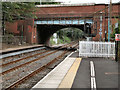
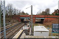
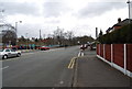
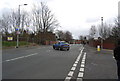
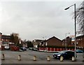
Living in M8 4FS means inhabiting a small, tightly knit residential cluster in England’s north-west. With a population of 1,814, the area is compact yet well-served by transport and retail. Daily life here balances proximity to urban conveniences with a quieter, community-oriented rhythm. Residents benefit from five metro stations, including Crumpsall and Bowker Vale, and five rail stops such as Salford Central and Moston, linking them to nearby cities. The area’s broadband score of 100 ensures seamless internet access, while mobile coverage of 85 supports reliable connectivity. Though small, M8 4FS offers a practical mix of shops, including Tesco Cheetham and Budgens Sedgeley, and public transport options that ease commutes. Its character lies in its accessibility and the presence of established infrastructure, making it a viable choice for those seeking a manageable, connected living environment without the pressures of larger urban centres.
- Area Type
- Postcode
- Area Size
- Not available
- Population
- 1814
- Population Density
- 6442 people/km²
The property market in M8 4FS is dominated by owner-occupied homes, with 64% of residents owning their properties. This contrasts with rental-heavy areas, indicating a focus on long-term residency rather than transient tenancy. The accommodation type is primarily houses, which is uncommon in more densely populated regions. This suggests a preference for single-family homes, potentially appealing to families or individuals seeking space and privacy. However, the area’s small size means the housing stock is limited, and buyers should consider proximity to surrounding zones for more options. The high home ownership rate may also reflect stable economic conditions, though the lack of specific data on property prices or trends means potential buyers must assess the market independently. For those prioritising ownership over rental flexibility, M8 4FS offers a straightforward, house-centric environment.
House Prices in M8 4FS
No properties found in this postcode.
Energy Efficiency in M8 4FS
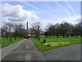
The lifestyle in M8 4FS is defined by its accessible amenities, including five retail outlets such as Tesco Cheetham and Budgens Sedgeley, which cater to everyday needs. The area’s proximity to five metro stations and five rail stops, including Salford Crescent and Abraham Moss, ensures easy access to public transport for shopping, work, or leisure. While there is only one bus stop at Chorlton Street Coach Station, the density of rail and metro options compensates for this. The presence of multiple transport hubs and shops suggests a convenience-focused environment, where residents can manage daily tasks without long commutes. However, the data does not specify parks or leisure facilities, meaning the area’s recreational offerings remain unclear. For those prioritising retail and transport, M8 4FS delivers a practical, connected lifestyle.
Amenities
Schools
| Rank | School | Type | Entry gender | Ages |
|---|
Explore more schools in this area
Go to Schools tabDemographics
The community in M8 4FS is predominantly composed of adults aged 30–64, with a median age of 47. Home ownership stands at 64%, reflecting a stable, long-term resident base. The area is largely made up of houses, which aligns with the demographic profile of families and older adults. The predominant ethnic group is White, though no specific data on diversity or deprivation is provided. This suggests a relatively uniform population structure, with fewer transient residents or younger households. The age distribution indicates a mature community, which may influence local services and amenities, such as the presence of retail outlets like Spar and Budgens. The lack of detailed diversity metrics means the area’s social fabric remains largely uncharacterised by demographic variation, which could be a consideration for those seeking a more eclectic environment.
Household Size
Accommodation Type
Tenure
Ethnic Group
Religion
Household Composition
Age
Household Deprivation
NS-SEC
Explore more demographic insights in this area
Go to Demographics tabPlanning
Planning Constraints
- Flood RiskPremium
- Ramsar Wetland SitesPremium
- Area of Outstanding Natural BeautyPremium
- Protected Nature ReservePremium
- Protected WoodlandPremium