Area Overview for M7 9XP
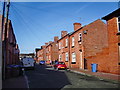
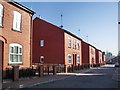
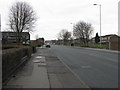
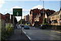
Photos of M7 9XP


Area Information
Living in M7 9XP means inhabiting a compact, residential postcode area in England with a population of 1,664. This small cluster of homes is characterised by its proximity to transport hubs, including multiple railway stations and metro stops, which offer swift access to Manchester’s urban core. The area’s demographic profile suggests a mature community, with a median age of 47 and a majority of residents aged 30–64. While the postcode is home to a modest number of properties, the low home ownership rate of 15% indicates a predominantly rental market. Daily life here is shaped by practical connectivity: nearby amenities include retail outlets like Asda Higher and Lidl Mocha, as well as the City Airport Manchester. The area’s digital infrastructure is robust, with a broadband score of 95, supporting remote work and online activities. However, the high crime risk score of 0/100 underscores the need for vigilance. For those seeking a quiet residential spot with easy access to transport and services, M7 9XP offers a blend of convenience and proximity to Manchester’s dynamic landscape.
- Area Type
- Postcode
- Area Size
- Not available
- Population
- 1664
- Population Density
- 9771 people/km²
The property market in M7 9XP is defined by its low home ownership rate of 15%, suggesting that the majority of housing is rented rather than owned. The accommodation type is primarily houses, which is unusual for a small postcode area, possibly indicating a mix of older, standalone properties. This dynamic implies a rental-focused market, where buyers may find limited opportunities for purchase. The small population size and modest housing stock mean the area is unlikely to have a large inventory of properties, which could make the market competitive for buyers. For those considering investment, the predominantly rental nature of the area may appeal to landlords, though the low home ownership rate also suggests a lack of long-term resident commitment. Buyers should consider the area’s practical advantages, such as transport links and proximity to amenities, alongside the challenges of a constrained housing supply.
House Prices in M7 9XP
No properties found in this postcode.
Energy Efficiency in M7 9XP
Residents of M7 9XP have access to a range of amenities within practical reach. Retail options include Asda Higher, Lidl Mocha, and Spar, providing everyday shopping convenience. The metro system, with stops at Victoria Station and Exchange Square, offers quick access to Manchester’s commercial and cultural hubs. Rail stations like Salford Central and Deansgate connect the area to broader networks, while the Chorlton Street Coach Station serves local routes. The City Airport Manchester is within reach, enhancing travel flexibility. The area’s compact size means amenities are closely clustered, reducing the need for long commutes. The mix of retail, transport, and travel options supports a practical lifestyle, though the limited number of leisure or recreational facilities suggests that residents may need to venture further for parks or entertainment.
Amenities
Schools
The nearest school to M7 9XP is the Manchester Jewish Grammar School, an independent institution. This school serves families seeking private education, though no other schools are listed in the data. The absence of state schools or other educational institutions may limit options for those prioritising a range of school types. For families relying on the Manchester Jewish Grammar School, its independent status offers structured academic and extracurricular programmes, but it also requires consideration of tuition costs and admissions criteria. The lack of additional schools in the area means residents may need to look beyond M7 9XP for broader educational choices, particularly for younger children or those seeking state-funded options.
| Rank | School | Type | Entry gender | Ages |
|---|
Explore more schools in this area
Go to Schools tabDemographics
The community in M7 9XP is predominantly composed of adults aged 30–64, with a median age of 47. This suggests a mature population, likely with established careers and families. Home ownership is exceptionally low at 15%, indicating that most residents are renters, which may reflect the area’s role as a secondary housing market. The accommodation type is primarily houses, though the small population size implies limited housing stock. The predominant ethnic group is White, with no data provided on other demographics. The low home ownership rate may contribute to a transient community feel, though the area’s proximity to transport links and amenities could attract professionals or commuters. The absence of specific data on deprivation or diversity means the quality of life is inferred from the availability of services and infrastructure, which appear adequate for basic needs.
Household Size
Accommodation Type
Tenure
Ethnic Group
Religion
Household Composition
Age
Household Deprivation
NS-SEC
Explore more demographic insights in this area
Go to Demographics tabPlanning
Planning Constraints
- Flood RiskPremium
- Ramsar Wetland SitesPremium
- Area of Outstanding Natural BeautyPremium
- Protected Nature ReservePremium
- Protected WoodlandPremium