Area Overview for M50 3XR
Photos of M50 3XR
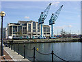
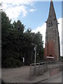
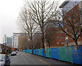

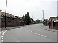


100 photos from this area
Area Information
Key information about the M50 3XR including its size, population, and administrative classification.
- Area Type
- Postcode
- Area Size
- 1.2 hectares
- Population
- 1030
- Population Density
- 3632 people/km²
House Prices in M50 3XR
24
Properties
£266,904
Average Sold Price
£80,000
Lowest Price
£590,000
Highest Price
Showing 24 properties
| Address | Type | Beds | Baths | Last Sale Price | Last Sale Date | |
|---|---|---|---|---|---|---|
| 30 Merchants Quay, Salford, M50 3XR | house | 4 | 2 | £590,000 | May 2025 | |
| 22 Merchants Quay, Salford, M50 3XR | house | 4 | 3 | £560,000 | Jul 2024 | |
| 44 Merchants Quay, Salford, M50 3XR | Flat | - | - | £263,000 | Dec 2023 | |
| 36 Merchants Quay, Salford, M50 3XR | Flat | 2 | 2 | £257,000 | Nov 2023 | |
| 8 Merchants Quay, Salford, M50 3XR | Terraced | 2 | - | £345,000 | Dec 2022 | |
| 20 Merchants Quay, Salford, M50 3XR | house | - | - | £420,000 | Feb 2021 | |
| 4 Merchants Quay, Salford, M50 3XR | Terraced | 2 | 2 | £295,000 | Apr 2020 | |
| 10A Merchants Quay, Salford, M50 3XR | Terraced | 3 | 2 | £415,000 | Jan 2020 | |
| 42 Merchants Quay, Salford, M50 3XR | Flat | 2 | 2 | £265,000 | Jan 2020 | |
| 16 Merchants Quay, Salford, M50 3XR | Terraced | 3 | 2 | £335,000 | Aug 2019 |
Page 1 of 3
Energy Efficiency in M50 3XR
Amenities
Schools
| Rank | School | Type | Entry gender | Ages |
|---|
Explore more schools in this area
Go to Schools tabDemographics
Household Size
One person
most common
Accommodation Type
Flats
most common
Tenure
17
majority
Ethnic Group
White
most common
Religion
N/A
most common
Household Composition
N/A
most common
Age
22
median
Young Adults (15-29 years)
most common
Household Deprivation
N/A
with no deprivation
NS-SEC
56
in Lower managerial occupations
Explore more demographic insights in this area
Go to Demographics tabPlanning
Planning Constraints
- Flood RiskPremium
- Ramsar Wetland SitesPremium
- Area of Outstanding Natural BeautyPremium
- Protected Nature ReservePremium
- Protected WoodlandPremium