Area Overview for M5 4PZ
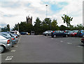
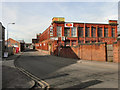
Photos of M5 4PZ


Area Information
M5 4PZ is a small residential postcode area in England, home to 2,941 people. It is a compact cluster of homes, primarily occupied by young adults aged 15–29, reflecting a community shaped by transient lifestyles and student or early-career populations. The area’s proximity to rail and metro networks makes it a practical choice for commuters, with Salford Crescent and Salford Central stations within reach. Daily life here balances convenience with limited local amenities, relying on nearby retail hubs like Spar and Iceland Salford for essentials. While the area has no significant natural constraints or flood risks, residents should note the high crime risk, which is above average. M5 4PZ is not a place for the risk-averse, but for those seeking affordability and connectivity, it offers a foothold in a dynamic part of Greater Manchester. Its small size means the character of the area is tightly woven with its immediate surroundings, where every development has a visible impact on the local scene.
- Area Type
- Postcode
- Area Size
- Not available
- Population
- 2941
- Population Density
- 4380 people/km²
The property market in M5 4PZ is characterised by a low home ownership rate of 22%, which points to a rental-dominated landscape. The accommodation type is primarily houses, but the area’s small size and limited housing stock suggest these properties are often split into smaller units or shared among tenants. This dynamic makes the area more attractive to renters than buyers, particularly young professionals or students seeking short-term accommodation. The lack of data on property prices or development plans means the market remains opaque, but the dominance of rental properties indicates limited scope for long-term investment. For buyers, the area’s compact nature means competition for available homes is likely to be intense, with little room for expansion. Those considering M5 4PZ should weigh the benefits of proximity to transport against the challenges of a volatile rental market.
House Prices in M5 4PZ
Showing 15 properties
Energy Efficiency in M5 4PZ
Life in M5 4PZ is shaped by its proximity to key amenities, though the area itself offers limited retail or leisure options. Residents can access nearby shops such as Spar, Iceland Salford, and Heron Pendleton, which provide essentials and light retail. The area’s transport links are its strongest asset, with multiple rail and metro stations enabling quick access to Manchester’s cultural and commercial hubs. The nearby Chorlton Street Coach Station and City Airport Manchester further enhance mobility. While there are no named parks or recreational spaces listed, the lack of protected natural areas suggests the area prioritises urban convenience over green spaces. The character of daily life here is defined by practicality: a reliance on public transport, proximity to urban amenities, and a community that thrives on connectivity rather than localised leisure.
Amenities
Schools
| Rank | School | Type | Entry gender | Ages |
|---|
Explore more schools in this area
Go to Schools tabDemographics
The population of M5 4PZ is overwhelmingly young, with a median age of 22 and the majority of residents falling within the 15–29 age range. This demographic profile suggests a community skewed toward students, young professionals, or those in early careers. Home ownership is low, at just 22%, indicating that most residents rent their homes. The accommodation type is predominantly houses, though the small area size and low ownership rate suggest these may be shared or rented in smaller units. The predominant ethnic group is White, reflecting a lack of demographic diversity in the area. While no specific deprivation data is provided, the high proportion of young renters implies a transient population with potential challenges in long-term stability. This dynamic profile means the area is likely to evolve rapidly, shaped by the needs and movements of its youthful inhabitants.
Household Size
Accommodation Type
Tenure
Ethnic Group
Religion
Household Composition
Age
Household Deprivation
NS-SEC
Explore more demographic insights in this area
Go to Demographics tabPlanning
Planning Constraints
- Flood RiskPremium
- Ramsar Wetland SitesPremium
- Area of Outstanding Natural BeautyPremium
- Protected Nature ReservePremium
- Protected WoodlandPremium