Area Overview for M44 5JZ
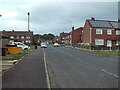
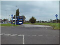
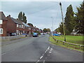
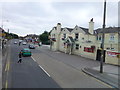
Photos of M44 5JZ


Area Information
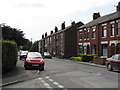
Living in M44 5JZ means inhabiting a small, tightly knit residential cluster in England. With a population of 1,480 and a density of 1,036 people per square kilometre, this area is compact yet functional, catering to a community that values proximity to amenities. The postcode is characterised by its housing stock, with most properties being houses rather than flats, reflecting a demographic skewed towards adults aged 30–64. Daily life here is shaped by the surrounding infrastructure: rail stations like Irlam and Glazebrook provide commuter links, while nearby retail hubs such as Tesco Central and Heron Partington offer convenience. The area’s small size means residents are likely to know their neighbours, though the high crime risk score—0 out of 100—demands awareness. Despite this, the broadband score of 97 ensures reliable internet for both work and leisure. M44 5JZ is not a sprawling suburb but a focused community, where the rhythm of life is defined by local schools, transport nodes, and the quiet hum of suburban living.
- Area Type
- Postcode
- Area Size
- Not available
- Population
- 1480
- Population Density
- 1036 people/km²
The property market in M44 5JZ is defined by high home ownership (74%) and a predominance of houses over flats or apartments. This suggests a market geared towards owner-occupiers rather than renters, with properties likely to be family homes. The small size of the area means the housing stock is limited, and buyers should consider the immediate surroundings for more options. The focus on houses indicates a preference for space and privacy, which may appeal to those seeking a traditional suburban lifestyle. However, the high crime risk score—0—could affect property desirability, despite the excellent broadband connectivity (97). For buyers, this area offers a niche market: a compact, residential cluster with established infrastructure but limited expansion. The lack of rental properties implies a community that values long-term investment, though the small population size means competition for available homes may be fierce.
House Prices in M44 5JZ
No properties found in this postcode.
Energy Efficiency in M44 5JZ
The lifestyle in M44 5JZ is shaped by its proximity to key amenities. Residents can access retail hubs like Tesco Central and Heron Partington, offering everyday shopping and dining options. The rail network, with stations such as Irlam and Glazebrook, provides easy access to nearby towns, while the metro stops at Timperley and Trafford Centre link to larger commercial areas. The nearby City Airport Manchester is a significant asset for those requiring frequent travel. For leisure, the area’s small size means community-focused activities, though specific parks or recreational spaces are not detailed in the data. The combination of retail, transport, and regional connectivity creates a practical living environment. While the area lacks detailed information on green spaces, the presence of multiple transport options and retail venues suggests a lifestyle prioritising convenience and accessibility over expansive natural amenities.
Amenities
Schools
The schools near M44 5JZ include Cadishead Nursery School and three instances of Cadishead Primary School. While the data does not provide Ofsted ratings, the presence of both nursery and primary schools suggests a focus on early education, which is vital for families with young children. The repetition of Cadishead Primary School in the data may indicate a single school serving multiple age groups or a data entry error, but it highlights the area’s commitment to education. For parents, the proximity of these schools reduces commuting time and supports a community-oriented lifestyle. However, the absence of secondary schools or higher education institutions means families may need to look beyond M44 5JZ for comprehensive schooling. The mix of nursery and primary options is a practical advantage, but the lack of diversity in school types could be a limitation for those requiring a broader educational range.
| Rank | School | Type | Entry gender | Ages |
|---|
Explore more schools in this area
Go to Schools tabDemographics
The community in M44 5JZ is predominantly middle-aged, with a median age of 47 and the majority of residents falling within the 30–64 age range. This suggests a population largely composed of working-age adults, many of whom are likely to be homeowners. Home ownership here is high, at 74%, indicating a stable, long-term resident base. The accommodation type is primarily houses, which aligns with the area’s residential character and the preference for family homes. The predominant ethnic group is White, though no specific data on diversity or deprivation levels is provided. The age profile implies a community with established careers and families, potentially with children attending local schools. The absence of younger demographics or a significant elderly population means the area may lack the generational diversity seen in larger towns. For buyers, this profile suggests a mature, settled environment, though the high crime risk score—0—raises questions about safety and the need for enhanced security measures.
Household Size
Accommodation Type
Tenure
Ethnic Group
Religion
Household Composition
Age
Household Deprivation
NS-SEC
Explore more demographic insights in this area
Go to Demographics tabPlanning
Planning Constraints
- Flood RiskPremium
- Ramsar Wetland SitesPremium
- Area of Outstanding Natural BeautyPremium
- Protected Nature ReservePremium
- Protected WoodlandPremium