Area Overview for M4 4NL
Photos of M4 4NL


Area Information
Living in M4 4NL means inhabiting a tightly packed residential cluster in England, where 1,522 people reside across just 2.1 hectares. The area’s high population density—73,591 people per square kilometre—reflects its compact nature, ideal for those prioritising proximity to urban hubs. Despite its small size, M4 4NL offers access to key amenities, including multiple rail stations, retail outlets, and educational institutions. The area’s character is shaped by its flat-based housing stock and mature demographic, with residents predominantly aged 30–64. While the compact layout ensures convenience, it also underscores the need for efficient transport networks, which are well-served by nearby metro, rail, and bus routes. However, residents must weigh the area’s advantages against its safety challenges, including critical flood and crime risk ratings. For buyers seeking a central location with immediate access to services, M4 4NL presents a focused, albeit high-density, option.
- Area Type
- Postcode
- Area Size
- 2.1 hectares
- Population
- 1522
- Population Density
- 2162 people/km²
The property market in M4 4NL is characterised by a low home ownership rate—just 24% of residents own their homes—with flats comprising the majority of accommodation. This suggests a rental-dominated market, where landlords and tenants outnumber owner-occupiers. The area’s small size and high density mean housing stock is limited, with little scope for expansion. For buyers, this implies competition for a limited number of properties, many of which are likely to be flats rather than detached or semi-detached homes. The compact nature of M4 4NL also means proximity to transport and amenities is a key selling point, though potential buyers should consider the area’s safety risks. Given the low home ownership, investors may find opportunities in rental yields, but buyers seeking long-term ownership should weigh the challenges of a saturated, high-density market.
House Prices in M4 4NL
No properties found in this postcode.
Energy Efficiency in M4 4NL
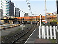
Daily life in M4 4NL is shaped by its proximity to retail, dining, and transport hubs. Nearby shops include M&S Cheetham Hill, Asda Living, and Co-op Manchester, offering a range of goods from groceries to clothing. The area’s rail and metro stations—such as Salford Central and Victoria—facilitate easy access to Manchester’s broader urban network. While parks and leisure facilities are not explicitly listed, the presence of multiple transport stops suggests a focus on urban convenience over green spaces. The compact layout means amenities are within walking distance, though residents may need to travel further for larger leisure options. This lifestyle suits those prioritising accessibility and proximity to services, though the area’s limited size may feel restrictive to those seeking more expansive recreational opportunities.
Amenities
Schools
The nearest school to M4 4NL is Eden Boys’ Leadership Academy in Manchester, an academy with a good Ofsted rating. This institution serves the area’s educational needs, offering a structured learning environment for local students. The presence of a single academy suggests a focus on secondary education, though no primary schools are listed in the data. For families, this means reliance on a single school type, which may limit options for younger children. The good Ofsted rating indicates a satisfactory standard of teaching and facilities, but parents should consider whether this aligns with their child’s specific needs. With no other schools mentioned, the area’s educational landscape is narrowly defined, requiring families to plan for potential travel to other districts for additional schooling options.
| Rank | School | Type | Entry gender | Ages |
|---|
Explore more schools in this area
Go to Schools tabDemographics
The community in M4 4NL is defined by its mature age profile, with a median age of 47 and the majority of residents falling within the 30–64 age range. Home ownership is relatively low at 24%, suggesting a rental market dominance. Flats are the primary accommodation type, reflecting the area’s compact footprint. The predominant ethnic group is White, though specific diversity metrics are not provided. The high population density—73,591 people per square kilometre—implies a mix of long-term residents and those drawn to the area’s proximity to transport and services. While the data does not specify deprivation levels, the combination of low home ownership and high density may indicate a population reliant on rental income or shared living arrangements. This demographic profile aligns with a community that values accessibility over space, with residents likely prioritising convenience over property ownership.
Household Size
Accommodation Type
Tenure
Ethnic Group
Religion
Household Composition
Age
Household Deprivation
NS-SEC
Explore more demographic insights in this area
Go to Demographics tabPlanning
Planning Constraints
- Flood RiskPremium
- Ramsar Wetland SitesPremium
- Area of Outstanding Natural BeautyPremium
- Protected Nature ReservePremium
- Protected WoodlandPremium