Area Overview for M4 4BA
Photos of M4 4BA


Area Information
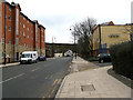
Living in M4 4BA means being part of a compact residential cluster in England, home to 1,859 residents. This area is defined by its proximity to urban infrastructure, with multiple metro stations, railway lines, and retail hubs within easy reach. The population is notably young, with a median age of 22 and the majority aged between 15 and 29. This demographic suggests a community centred around students, young professionals, and early-career individuals. Daily life here is shaped by the availability of public transport, including five nearby railway stations and five metro stops, which connect residents to Manchester’s broader network. The area’s small size means it is likely integrated into surrounding neighbourhoods, offering a mix of convenience and accessibility. However, the high crime risk—described as critical—requires residents to consider security measures. Despite this, the area’s proximity to amenities like Co-op Balloon and Spar, along with its transport links, makes it a practical choice for those prioritising connectivity over isolation.
- Area Type
- Postcode
- Area Size
- Not available
- Population
- 1859
- Population Density
- 7172 people/km²
The property market in M4 4BA is characterised by a low home ownership rate—just 14% of residents own their homes—suggesting that the area functions more as a rental market than an owner-occupied one. The predominant accommodation type is flats, which are typical in urban or densely populated zones. This configuration may appeal to renters seeking affordable, compact living spaces, particularly given the area’s proximity to transport links and amenities. However, the small size of the postcode area means the housing stock is limited, and buyers may need to consider nearby neighbourhoods for more options. The focus on flats also implies that property values are likely lower compared to areas with larger homes or higher ownership rates. For those considering investment, the market’s rental orientation could offer opportunities, though the high crime risk may deter some buyers.
House Prices in M4 4BA
No properties found in this postcode.
Energy Efficiency in M4 4BA
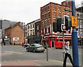
Residents of M4 4BA enjoy a range of amenities within practical reach, enhancing daily life. The area’s retail options include Co-op Balloon, Spar, and Co-op Manchester, offering essential shopping with minimal travel. Public transport is extensive, with five metro stops and five railway stations providing connections to Manchester’s business and cultural hubs. The Chorlton Street Coach Station adds convenience for local and regional travel. While the data does not mention parks or leisure facilities, the proximity to metro and rail stations suggests access to urban amenities such as cafes, restaurants, and entertainment venues. The combination of retail, transport, and connectivity creates a functional environment for young professionals and students, though the lack of specific leisure data means the full lifestyle offering remains partially defined.
Amenities
Schools
Residents of M4 4BA have access to two nearby schools: The Cooperative College, which is categorised as an 'other' school, and Digital Advantage, a special school. These institutions cater to a range of educational needs, with Digital Advantage likely providing tailored support for students with specific requirements. The presence of a special school suggests the area may serve a community with diverse educational needs, though no Ofsted ratings or academic performance data are available. The Cooperative College’s designation as 'other' could indicate it is a further education or vocational institution, potentially offering courses beyond traditional schooling. For families, the combination of school types provides options but may not cover all age groups or academic pathways. Parents should investigate further to confirm whether these schools meet their children’s needs, as the data does not specify intake sizes or facilities.
| Rank | School | Type | Entry gender | Ages |
|---|
Explore more schools in this area
Go to Schools tabDemographics
The community in M4 4BA is predominantly young, with a median age of 22 and the majority of residents falling within the 15–29 age range. This suggests a population skewed towards students, recent graduates, and young professionals. Home ownership is low, with only 14% of households owning their homes, indicating that most residents are renters. The accommodation type is largely flats, reflecting a housing stock suited to smaller households or individuals. The predominant ethnic group is White, though specific data on diversity or deprivation is not provided. The youth demographic and rental focus imply a transient population, with limited long-term residential stability. This profile aligns with areas near educational institutions or employment hubs, where short-term tenancies are common. The lack of data on household composition or income levels means the full picture of the community’s socioeconomic dynamics remains incomplete.
Household Size
Accommodation Type
Tenure
Ethnic Group
Religion
Household Composition
Age
Household Deprivation
NS-SEC
Explore more demographic insights in this area
Go to Demographics tabPlanning
Planning Constraints
- Flood RiskPremium
- Ramsar Wetland SitesPremium
- Area of Outstanding Natural BeautyPremium
- Protected Nature ReservePremium
- Protected WoodlandPremium