Area Overview for M34 3UU
Photos of M34 3UU


Area Information
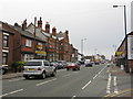
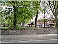
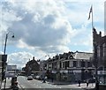
Living in M34 3UU offers a quiet, compact residential experience within a small cluster of homes. With a population of 1,692, the area feels close-knit, though its size means it is not a bustling hub but rather a defined postcode with a focus on local living. The community is predominantly composed of adults aged 30–64, reflecting a mature demographic that may prioritise stability and established neighbourhoods. Daily life here is likely shaped by proximity to rail and metro networks, which connect residents to nearby towns and cities. While the area lacks major landmarks or natural features, its practicality lies in its accessibility. Residents benefit from strong broadband connectivity, which supports remote work and digital lifestyles. However, the area’s small scale means amenities are limited to nearby retail and transport hubs. For those seeking a low-maintenance, commuter-friendly environment with minimal environmental constraints, M34 3UU provides a straightforward option.
- Area Type
- Postcode
- Area Size
- Not available
- Population
- 1692
- Population Density
- 3397 people/km²
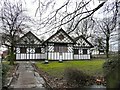
The property market in M34 3UU is characterised by a 52% home ownership rate, with houses being the primary accommodation type. This suggests a market skewed towards owner-occupied properties rather than rental units, though the relatively low home ownership percentage indicates that a significant portion of the housing stock may be rented or occupied by other means. The prevalence of houses implies a focus on single-family homes, which may appeal to those seeking private, spacious living arrangements. However, the area’s small size means the housing stock is limited, and buyers should consider the proximity to nearby towns for broader options. For those prioritising ownership, the market may offer opportunities, but the lack of data on property prices or availability means potential buyers should investigate local listings. The predominance of houses also suggests a community that values traditional residential structures over flats or apartments.
House Prices in M34 3UU
No properties found in this postcode.
Energy Efficiency in M34 3UU
Residents of M34 3UU have access to a range of nearby amenities, including five retail stores such as Aldi Crownpoint, Lidl Audenshaw, and Morrisons Audenshaw, which provide essential shopping options. The area’s proximity to rail and metro stations—Denton, Guide Bridge, and Fairfield—facilitates travel to nearby towns for leisure or work. While the specific names of parks or leisure facilities are not listed, the absence of protected natural areas or planning constraints suggests that the landscape is not heavily restricted. The practical reach of amenities like supermarkets and transport hubs contributes to a functional daily life, though the area’s small size means residents may need to travel further for more specialised services. The combination of retail access and transport links offers a balance between convenience and the need for nearby towns for broader amenities.
Amenities
Schools
| Rank | School | Type | Entry gender | Ages |
|---|
Explore more schools in this area
Go to Schools tabDemographics
The population of M34 3UU has a median age of 47, with the majority of residents falling within the 30–64 age range. This suggests a community of middle-aged individuals, likely in their prime working years or approaching retirement. Home ownership stands at 52%, indicating that nearly half of residents live in their own homes, while the remaining 48% may be renters or in other housing arrangements. The predominant accommodation type is houses, which aligns with the area’s residential character. The dominant ethnic group is White, though no specific data on diversity or deprivation levels is provided. This demographic profile suggests a stable, established community with limited generational turnover. The absence of specific data on deprivation means it is unclear how economic factors might influence quality of life, but the age range and home ownership rate imply a population that may value security and long-term residency.
Household Size
Accommodation Type
Tenure
Ethnic Group
Religion
Household Composition
Age
Household Deprivation
NS-SEC
Explore more demographic insights in this area
Go to Demographics tabPlanning
Planning Constraints
- Flood RiskPremium
- Ramsar Wetland SitesPremium
- Area of Outstanding Natural BeautyPremium
- Protected Nature ReservePremium
- Protected WoodlandPremium