Area Overview for M34 3RZ
Photos of M34 3RZ


Area Information
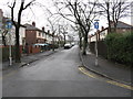
Living in M34 3RZ offers a compact, residential experience shaped by its small cluster of homes and proximity to key services. With a population of 1,210, the area is tightly knit, catering to a mature demographic. The median age of 47 suggests a community rooted in stability, with many residents in their 30s to 60s. This is a place where homeownership is common — 60% of properties are owner-occupied — and the housing stock is predominantly single-family homes. Daily life here is defined by practicality: the area lacks natural beauty or protected landscapes but is served by reliable transport links and retail options. Residents benefit from excellent broadband connectivity, though crime rates are notably high, requiring vigilance. For those seeking a quiet, low-flood-risk environment with access to rail and local shops, M34 3RZ presents a straightforward, if unremarkable, proposition. Its charm lies in simplicity, not spectacle.
- Area Type
- Postcode
- Area Size
- Not available
- Population
- 1210
- Population Density
- 2363 people/km²
The property market in M34 3RZ is defined by a 60% homeownership rate, with houses forming the majority of the housing stock. This suggests a market skewed toward owner-occupied homes rather than rentals, though the small population of 1,210 indicates limited inventory. The area’s compact size means buyers must consider proximity to amenities and transport as critical factors. With no large-scale developments or estate complexes, properties here are likely to be individual homes, possibly semi-detached or terraced. For buyers, the challenge lies in the area’s limited scale: competition for homes is likely to be fierce, and the market may lack the diversity of options found in larger towns. Those seeking a quiet, low-flood-risk home with access to rail and retail should focus on the immediate vicinity, where the cluster of houses is concentrated.
House Prices in M34 3RZ
No properties found in this postcode.
Energy Efficiency in M34 3RZ
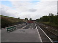
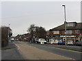
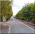
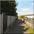
Daily life in M34 3RZ is shaped by its proximity to essential amenities. Retail options include Aldi Crownpoint, Sainsburys Denton, and Lidl Audenshaw, providing grocery and household needs within walking or short driving distance. The area’s rail network is robust, with Denton, Fairfield, and Guide Bridge stations offering links to Manchester and beyond. Metro services like Audenshaw and Droylsden stations further expand mobility, while the Chorlton Street Coach Station provides a single bus route. Though the area lacks large parks or cultural venues, its practical layout ensures residents can access shopping, transport, and basic services without long commutes. The lifestyle here is straightforward: convenience and accessibility take precedence over leisure or scenic attractions. For those valuing functional living over luxury, M34 3RZ delivers.
Amenities
Schools
| Rank | School | Type | Entry gender | Ages |
|---|
Explore more schools in this area
Go to Schools tabDemographics
The community in M34 3RZ is predominantly composed of adults aged 30 to 64, with a median age of 47. This suggests a mature, settled population, likely with established careers and family ties. Homeownership rates are robust at 60%, indicating a preference for long-term residence over rental living. The area’s accommodation is largely houses, which aligns with the demographic’s likely need for space and stability. The predominant ethnic group is White, though no specific diversity metrics are provided. The absence of data on deprivation or socioeconomic breakdown means the quality of life can only be inferred from the available statistics. With no protected natural areas or planning constraints, the community’s character is shaped by its residential focus and proximity to transport hubs rather than environmental or cultural features.
Household Size
Accommodation Type
Tenure
Ethnic Group
Religion
Household Composition
Age
Household Deprivation
NS-SEC
Explore more demographic insights in this area
Go to Demographics tabPlanning
Planning Constraints
- Flood RiskPremium
- Ramsar Wetland SitesPremium
- Area of Outstanding Natural BeautyPremium
- Protected Nature ReservePremium
- Protected WoodlandPremium