Area Overview for M33 2YD
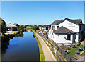
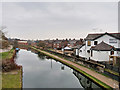
Photos of M33 2YD


Area Information
M33 2YD is a small residential cluster in England with a population of 2158, offering a compact, tightly knit community. The area is characterised by its mix of practical living and accessible connectivity, with residents benefiting from proximity to multiple transport hubs. Daily life here is shaped by its location near Sale, Dane Road, and Brooklands, which provide a blend of local amenities and regional links. The area’s appeal lies in its balance of residential tranquillity and ease of access to urban centres. With a median age of 47, the community is predominantly composed of adults aged 30–64, suggesting a stable, established demographic. While the area is small, its strategic placement near rail, metro, and airport infrastructure makes it a practical choice for commuters and those prioritising mobility. The low flood risk and absence of protected natural sites further contribute to a straightforward living environment, though the high crime risk requires careful consideration. For buyers seeking a manageable, connected home with nearby services, M33 2YD presents a focused opportunity.
- Area Type
- Postcode
- Area Size
- Not available
- Population
- 2158
- Population Density
- 4868 people/km²
The property market in M33 2YD is defined by its 64% home ownership rate and a reliance on flats as the primary accommodation type. This indicates a community where many residents own their homes, though the market is not exclusively owner-occupied. The prevalence of flats suggests a focus on high-density living, which may appeal to buyers seeking affordable, manageable properties in a connected area. Given the small size of the postcode, the housing stock is limited, and buyers may need to consider adjacent areas for more options. The flat-dominated market may also reflect the area’s proximity to transport hubs, making it attractive to commuters. However, the lack of data on property prices or rental yields means that buyers should investigate local listings to gauge current market conditions.
House Prices in M33 2YD
No properties found in this postcode.
Energy Efficiency in M33 2YD
Living in M33 2YD grants access to a range of amenities within practical reach. The area is served by five retail outlets, including Sainsburys, Aldi, and Tesco in Sale, ensuring everyday shopping needs are met. Metro stations like Sale and Brooklands provide links to local attractions and transport corridors. Rail services at Urmston and Trafford Park stations connect to broader regional networks, while proximity to Manchester’s City Airport offers travel convenience. A single bus stop at Chorlton Street adds to the transport options. The presence of multiple retail and transport hubs suggests a functional, accessible lifestyle, though the small area size means residents may need to travel further for more specialised services. The combination of retail, transport, and connectivity makes daily life here practical and efficient.
Amenities
Schools
| Rank | School | Type | Entry gender | Ages |
|---|
Explore more schools in this area
Go to Schools tabDemographics
The population of M33 2YD is 2158, with a median age of 47, reflecting a community dominated by adults aged 30–64. This age range suggests a mature, settled population, likely with established careers and family structures. Home ownership accounts for 64% of households, indicating a mix of owner-occupied properties and rentals. The accommodation type is predominantly flats, which aligns with the area’s compact residential character. The predominant ethnic group is White, though specific data on diversity is not provided. The absence of detailed deprivation metrics means that quality of life factors such as access to services and safety remain key considerations. The high proportion of owner-occupiers and the focus on flats suggest a practical, functional housing market tailored to those seeking manageable, centrally located living spaces.
Household Size
Accommodation Type
Tenure
Ethnic Group
Religion
Household Composition
Age
Household Deprivation
NS-SEC
Explore more demographic insights in this area
Go to Demographics tabPlanning
Planning Constraints
- Flood RiskPremium
- Ramsar Wetland SitesPremium
- Area of Outstanding Natural BeautyPremium
- Protected Nature ReservePremium
- Protected WoodlandPremium