Area Overview for M32 0BU
Photos of M32 0BU


Area Information
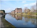
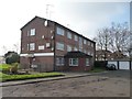
Living in M32 0BU offers a quiet, residential lifestyle within a small cluster of homes. With a population of 2,599, this area is compact but well-served by nearby amenities. The community is predominantly composed of adults aged 30–64, reflecting a mature demographic with strong ties to family living. Most properties are owner-occupied, with a focus on houses rather than flats, creating a distinct character from larger urban centres. Daily life here balances local convenience with proximity to Manchester’s transport networks. The area’s small size means a tight-knit community feel, where neighbours are likely to be familiar faces. While it lacks the vibrancy of city hubs, M32 0BU provides a stable, low-traffic environment. Residents benefit from proximity to Stretford and surrounding areas, where retail, leisure, and transport options are accessible. For those seeking a peaceful, family-oriented setting with practical connectivity, this postcode offers a blend of simplicity and functionality.
- Area Type
- Postcode
- Area Size
- Not available
- Population
- 2599
- Population Density
- 3214 people/km²
M32 0BU is primarily an owner-occupied area, with 55% of homes owned by residents rather than rented. The accommodation type is predominantly houses, which is unusual for areas with higher flat density. This suggests a focus on family homes and larger properties, appealing to those seeking space and privacy. The small size of the postcode means the housing stock is limited, but the emphasis on owner-occupation indicates a stable market with long-term residents. Buyers should consider that the area’s compact nature may restrict availability, though the presence of houses could cater to those prioritising living space. The lack of rental properties means the market is less influenced by transient demand. For those seeking a home in this area, the emphasis on houses and owner-occupation suggests a focus on permanence rather than investment.
House Prices in M32 0BU
No properties found in this postcode.
Energy Efficiency in M32 0BU
Residents of M32 0BU have access to a range of amenities within practical reach. Retail options include Co-op Taylors, Lidl Stretford, and Tesco Stretford, providing everyday shopping convenience. The area’s proximity to rail and metro stations, such as Trafford Park and Old Trafford, connects residents to larger urban centres for dining, entertainment, and cultural activities. While specific parks or leisure facilities are not listed, the presence of multiple transport hubs suggests access to nearby green spaces and recreational areas in Stretford or Manchester. The area’s small size means it relies on surrounding towns for broader amenities, but the ease of travel via rail and metro mitigates this. The mix of retail, transport, and proximity to major landmarks like Manchester United FC railway station offers a lifestyle that balances local convenience with urban accessibility.
Amenities
Schools
Residents of M32 0BU have access to two primary schools with good Ofsted ratings: Gorse Hill Primary School and Stretford High School. Both institutions provide quality education for younger children, though the absence of secondary schools nearby means families may need to look further afield for high school options. The presence of two primary schools within practical reach offers convenience for parents, reducing travel time for children’s commutes. The good Ofsted ratings suggest these schools meet or exceed national standards in teaching and facilities. However, the area’s small size means no additional educational institutions are present. For families prioritising primary education, this is a strength, but secondary schooling would require planning for travel to larger towns like Stretford or Manchester.
| Rank | School | Type | Entry gender | Ages |
|---|
Explore more schools in this area
Go to Schools tabDemographics
The population of M32 0BU is 2,599, with a median age of 47, indicating a mature community. The most common age group is adults aged 30–64, suggesting a mix of established families and professionals. Home ownership stands at 55%, with houses being the predominant accommodation type. This reflects a settled, long-term resident base rather than a transient rental market. The predominant ethnic group is White, aligning with broader regional demographics. The absence of specific deprivation data means the area’s quality of life is inferred from its amenities and safety assessments. The age profile implies a community with a strong focus on stability, where families and older residents form the majority. This demographic profile shapes local services, with schools and retail tailored to adult and family needs. The low proportion of younger residents may influence the pace of change in the area, maintaining its established character.
Household Size
Accommodation Type
Tenure
Ethnic Group
Religion
Household Composition
Age
Household Deprivation
NS-SEC
Explore more demographic insights in this area
Go to Demographics tabPlanning
Planning Constraints
- Flood RiskPremium
- Ramsar Wetland SitesPremium
- Area of Outstanding Natural BeautyPremium
- Protected Nature ReservePremium
- Protected WoodlandPremium